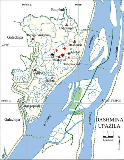
Dashmina Upazila
Dashmina Upazila (patuakhali district) area 351.87 sq km, located in between 22°08' and 22°22' north latitudes and in between 90°28' and 90°39' east longitudes. It is bounded by bauphal upazila on the north, galachipa upazila on the south, lalmohan and char fasson upazilas on the east, Galachipa upazila on the west.
Population Total 123388; male 60241, female 63147; Muslim 115532, Hindu 7850 and Christian 6.
Water bodies Main river: tentulia.
Administration Dashmina Thana was formed in 1979 and it was turned into an upazila in 1983.
| Upazila | ||||||||
| Municipality | Union | Mouza | Village | Population | Density (per sq km) | Literacy rate (%) | ||
| Urban | Rural | Urban | Rural | |||||
| - | 6 | 50 | 51 | 19252 | 104136 | 351 | 57.0 | 47.2 |
| Upazila Town | ||||||||
|
Area |
Mouza |
Population |
Density |
Literacy rate | ||||
| 19.99 | 3 | 19252 | 963 | 57.0 | ||||
| Union | ||||
| Name of union and GO code | Area (acre) | Population | Literacy rate (%) | |
| Male | Female | |||
| Alipur 10 | 10618 | 10183 | 10355 | 50.0 |
| Dashmina 52 | 21994 | 13234 | 14153 | 53.2 |
| Bahrampur 21 | 9931 | 7476 | 8494 | 49.0 |
| Banshbaria 31 | 894 | 8850 | 9409 | 51.5 |
| Betagi Sankipura 42 | 10243 | 9620 | 10038 | 49.6 |
| Rangopaldi 84 | 25225 | 10878 | 10698 | 38.5 |
Source Bangladesh Population Census 2011, Bangladesh Bureau of Statistics.

War of Liberation After having arms training the freedom fighters of the upazila carried out operations as group of their own as well as in joint team of freedom fighters coming from neighboring areas. However, since movements in most places of the upazila had been extremely difficult because of poor transport network, the Pakistani soldiers and their local collaborators did not have much activities here and there had been no direct encounter of the freedom fighters with the Pak army.
For details: see দশমিনা উপজেলা, বাংলাদেশ মুক্তিযুদ্ধ জ্ঞানকোষ (Encyclopedia of Bangladesh War of Liberation), বাংলাদেশ এশিয়াটিক সোসাইটি, ঢাকা ২০২০, খণ্ড ৪।
Religious institutions Mosque 468, temple11, tomb 2, most noted of which are Munshi Amirullah Mosque at Adampur-Baharampur, Sikdar Bari Mosque (Betagi Sankipura), Talukdar Bari Mosque (Dashmina).
Literacy rate and educational institutions Average literacy 48.7%; male 52.6%, female 45.1%. Educational institutions: college 2, secondary school 25, primary school 109, madrasa 19. Noted educational institutions: Abdur Rashid Talukdar Degree College (1977), Alipur College (1999), Dashmina Secondary School (1956), Gachhani Secondary School (1958), Chandpura ABC Secondary School (1960), Nehalganj Secondary School (1967), Dashmina Ideal Primary School (1954), Dashmina Islamia Senior Fazil Madrasa (1968), Adampur Islamia Senior Madrasa (1965), Char Hosnabad Senior Madrasa (1964).
Newspapers and periodicals Defunct: Dashmina Barta, Desh Katha.
Cultural organisations Library 2, club17, women's organisation 1, cinema hall 1.
Main sources of income Agriculture 64.86%, non-agricultural labourer 5.69%, industry 0.57%, commerce 10.25%, transport and communication 1.99%, service 5.88%, construction 1.48%, religious service 0.25%, rent and remittance 0.13% and others 8.90%.
Main crops Paddy, potato, pulse, chili, water melon, vegetables.
Extinct or nearly extinct crops Kaun.
Main fruits Banana, jackfruit, papaya, pineapple.
Fisheries, dairies and poultries This upazila has a number of fisheries and dairies.
Communication facilities Pucca road 85 km, semi-pucca road 10 km, mud road 813 km; waterway 66 km.
Extinct or nearly extinct traditional transport Palanquin.
Noted manufactories Rice mill, oil mill, ice cream factory, workshop.
Cottage industries Bamboo work, weaving, button work, coconut fiber work.
Hats, bazars and fairs Hats and bazars are 41, most noted of which are Dashmina Hat, Nalkhola Hat, Arajbegi Hat, Rangopaldi Hat and Gachhani Hat.
Main exports Hilsa fish.
Access to electricity All the unions of the upazila are under rural electrification net-work. However 14.1% of the dwelling households have access to electricity.
Natural resources Fisheries and forest resources.
Sources of drinking water Tube-well 94.6%, tap 0.2% and others 5.2%.
Sanitation 76.1% of dwelling households of the upazila use sanitary latrines and 21.2% of dwelling households use non-sanitary latrines; 2.7% of households do not have latrine facilities.
Health centres Upazila health complex 1, satellite clinic 6, NGO operated health centre 1.
Natural disasters The devastating cyclones of 1584, 1822, 1960 and 1970 and the flood of 1876 caused huge loss of life and damages to settlements, livestock and other properties of the upazila.
NGO activities asa, brac, VOSD, BDS, PDO. [Gazi Shahidul Islam]
References Bangladesh Population Census 2001 and 2011, Bangladesh Bureau of Statistics; Cultural survey report of Dashmina Upazila 2007.
