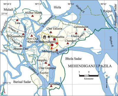
Mehendiganj Upazila
Mehendiganj Upazila (barisal district) area 418.96 sq km, located in between 22°41' and 23°55' north latitudes and in between 90°23' and 90°38' east longitudes. It is bounded by hizla and muladi upazilas on the north, barisal sadar and bhola sadar upazilas on the south, Bhola Sadar, lakshmipur sadar and raipur upazilas on the east, Muladi and Barisal Sadar upazilas on the west.
Population Total 301046; male 146926, female 154120; Muslim 289308, Hindu 11681, Buddhist 21, Christian 13 and others 23.
Water bodies Main rivers: meghna, Lata, arial khan, tentulia, Dharmaganj, Azimpur, Naya Bhanga, Chilmari and Sultani.
Administration Mehendiganj Thana was turned into an upazila on 15 October 1983.
| Upazila | ||||||||
| Municipality | Union | Mouza | Village | Population | Density (per sq km) | Literacy rate (%) | ||
| Urban | Rural | Urban | Rural | |||||
| 1 | 13 | 119 | 142 | 33802 | 267244 | 719 | 63.8 (2001) | 46.6 |
| Municipality | ||||||||
|
Area (sq km) |
Ward |
Mahalla |
Population |
Density (per sq km) |
Literacy rate (%) | |||
| 14.96 (2001) | 9 | 11 | 30067 | 1957 (2001) | 64.3 | |||
| Upazila Town | ||||||||
|
Area (sq km) |
Mouza |
Population |
Density (per sq km) |
Literacy rate (%) | ||||
| 2.29 (2001) | 1 | 3735 | 1603 (2001) | 55.5 | ||||
| Union | ||||
| Name of union and GO code | Area (acre) | Population | Literacy rate (%) | |
| Male | Female | |||
| Andhar Manik 15 | 6106 | 9964 | 10956 | 55.8 |
| Alimabad 13 | 12913 | 14761 | 15029 | 31.6 |
| Ulania 94 | 6096 | 25345 | 25732 | 46.5 |
| Gobindapur 40 | 10580 | 4150 | 4008 | 56.8 |
| Char Gopalpur 55 | 6593 | 6375 | 6611 | 52.0 |
| Char Ekkaria 47 | 11548 | 15529 | 16446 | 53.9 |
| Chandpur 39 | 4212 | 10070 | 11114 | 48.5 |
| Jangalia 71 | 8845 | 10438 | 9986 | 45.2 |
| Dari Char Khajuria 63 | 4687 | 5126 | 5316 | 42.3 |
| Bidyanandapur 31 | 7667 | 6140 | 6632 | 33.5 |
| Bhasan Char 23 | 4524 | 8064 | 8774 | 42.0 |
| Mehendiganj 87 | 5777 | 7185 | 7852 | 48.3 |
| Lata 79 | 7141 | 9244 | 10132 | 54.1 |
Source Bangladesh Population Census 2001 and 2011, Bangladesh Bureau of Statistics.

Archaeological heritage and relics Ulania Zamindar Bari and Mosque, statue of Basudeb, Kella (fort) of Sangram Singh (built during the Mughal period).
War of Liberation Freedom fighters had their first encounter with the Pak army in the upazila at a place between Ulania and Vashanchar towards the end of July 1971. They later carried out operations at Kalikapur, Mahendiganj Police Station and Mehendiganj river port. A memorial monument has been built at Patarhat RC College compound.
For details: see মেহেন্দীগঞ্জ উপজেলা, বাংলাদেশ মুক্তিযুদ্ধ জ্ঞানকোষ (Encyclopedia of Bangladesh War of Liberation), বাংলাদেশ এশিয়াটিক সোসাইটি, ঢাকা ২০২০, খণ্ড ৮।
Religious institutions Mosque 330, temple 28.
Literacy rate and educational institutions Average literacy 48.6%; male 46.4%, female 50.6%. Educational institutions: college 5, secondary school 30, primary school 70, madrasa 113. Noted educational institutions: Patarhat' RC College, Ekta College, Ulania Mujaffar Khan College, Andhar Manik Secondary School, Amirganj Secondary School, Laskarpur Uttar Jangalia Secondary School, Udaypur Muslim Akandh Secondary School, Ulania Cornation Secondary School, Ulania Girls' Secondary School, Kalikapur Romij Memorial Secondary School, Patarhat Muslim High School (1924), Bhasan Char SM High School (1943), Andhar Manik Azimpur Dakhil Madrasa, Andhar Manik Alimabad Islamia Senior Madrasa, Aslamia Isalamia Dakhil Madrasa, Ulania Ahmadia Girls' Dakhil Madrasa, Patarhat Senior Madrasa, Bhasan Char Nesaria Senior Madarasa, Madartali Islamia Senior Madrasa, Santoshpur Senior Madrasa.
Cultural organisations Library 1, club 42, cinema hall 1, women organisation 5, playground 35, theatre group 1.
Main sources of income Agriculture 59.76%, non-agricultural labourer 4.33%, commerce 13.68%, transport and communication 1.44%, service 7.55%, construction 1.70%, rent and remittance 2.45% and others 9.09%.
Ownership of agricultural land Landowner 58.85%, landless 41.15%; agricultural landowner: urban 52.30% and rural 59.62%.
Main crops Paddy, jute, wheat, pulse, sweet potato, onion, betel leaf, sugarcane, vegetables.
Extinct or nearly extinct crops Sesame, linseed, kaun, mustard.
Main fruits Mango, jackfruit, banana, litchi, blackberry, palm, coconut, custard apple, betel nut.
Fisheries, dairies and poultries Fishery 51, poultry 174, hatchery10.
Communication facilities Pucca road 41.28 km, semi-pucca road 134.51 km, mud road 906.32 km; waterway 400 km.
Extinct or nearly extinct traditional transport Palanquin, horse carriage, bullock cart.
Noted manufactories Flour mill 1, ice factory 5, biscuit factory 20, salt factory 1, bidi factory 1.
Cottage industries Blacksmith 50, potteries 86, mat manufacturing 56, bamboo work 20, nakshi kantha 18.
Hats, bazars and fairs Hats and bazars are 28, fair 1, most noted of which are Patarhat, Ulania Hat, Court Hat, Banglabazar Kazir Hat and Dafadar Hat.
Main exports Betel leaf, onion, sweet potato, betel nut, pulse.
Access to electricity All the wards and unions of the upazila are under rural electrification net-work. However 26.2% of the dwelling households have access to electricity.
Sources of drinking water Tube-well 91.4%, tap 0.4% and others 8.2%.
Sanitation 73.0% of dwelling households of the upazila use sanitary latrines and 25.0% of dwelling households use non-sanitary latrines; 2.0% of households do not have latrine facilities.
Health centres Upazila health complex 1, family planning centre 13, satellite clinic 4.
Natural disasters The floods of 1822 and 1895 and the cyclones of 1864, 1961 and 1965 caused heavy damages to settlements, properties and other crops of the upazila.
NGO activities Operationally important NGOs are brac, caritas, asa, proshika. [Ahsan Habib]
References Bangladesh Population Census 2001 and 2011, Bangladesh Bureau of Statistics; Cultural survey report of Mehendiganj Upazila 2007.
