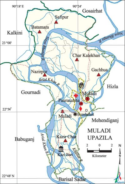
Muladi Upazila
Muladi Upazila (barisal district) area 260.85 sq km, located in between 22°47' and 23°03' north latitudes and in between 90°17' and 90°27' east longitudes. It is bounded by gosairhat upazila on the north, barisal sadar upazila on the south, hizla and mehendiganj upazilas on the east, kalkini, gaurnadi and babuganj upazilas on the west.
Population Total 174775; male 82545, female 92230; Muslim 171485, Hindu 3275, Buddhist 2, Christian 8 and others 5.
Water bodies Main rivers: Naya Bhanga, arial khan, Khaliar.
Administration Muladi Thana was formed in 1899 and it was turned into an upazila on 24 March 1983.
| Upazila | ||||||||
| Municipality | Union | Mouza | Village | Population | Density (per sq km) | Literacy rate (%) | ||
| Urban | Rural | Urban | Rural | |||||
| 1 | 7 | 77 | 102 | 20490 | 154285 | 670 | 62.6 | 55.1 |
| Municipality | ||||||||
|
Area (sq km) |
Ward |
Mahalla |
Population |
Density (per sq km) |
Literacy rate (%) | |||
| 16.96 | 9 | 14 | 20490 | 1208 | 62.6 | |||
| Union | ||||
| Name of union and GO code | Area (acre) | Population | Literacy rate (%) | |
| Male | Female | |||
| Kazir Char 47 | 8041 | 9285 | 10302 | 55.9 |
| Gachhua 35 | 5844 | 7470 | 8467 | 55.7 |
| Char Kalekhan 23 | 5176 | 8961 | 10062 | 53.4 |
| Nazirpur 71 | 8156 | 10692 | 11825 | 56.8 |
| Batamara 11 | 7640 | 10105 | 11835 | 58.3 |
| Muladi 59 | 7236 | 10293 | 11263 | 56.5 |
| Safipur 83 | 10648 | 15524 | 18201 | 50.9 |
Source Bangladesh Population Census 2011, Bangladesh Bureau of Statistics.

Archaeological heritage and relics Mia Bari Mosque at Gachhua, ancient mosque at village Syedergaon, Sultan Khan Mosque at village Gangapur.
Historical events Once Muladi was under the Dhaka-Jamalpur Revenue District. Up to 1873 there was only one revenue agent (intermediary collector) here and by 1908 there were many other agents in this region and among them, the Takulder and the Howlader groups were the most influential. In 1951, after the permanent settlement, a Revenue Circle Officer was appointed in Muladi Thana. The people of Muladi played an important role in the PARTITION OF BENGAL movement (in 1905), khilafat movement and in the language movement of 1952.
War of Liberation In 1971 the Pak army killed 42 persons by mortar shells and firing from machine gun on both sides of the river. The freedom fighters destroyed the gunboat of the Pak army at Nandil Bazar; following this incident the Pak army conducted a week long mass killing operation in the Kaliganj area. Freedom fighters had encounters with Pak army at Muladi Police Station, ferry terminal of Hosnabad and some other places of the upazila. There is a graveyard of valiant freedom fighters at Khaserhat.
For details: see মুলাদী উপজেলা, বাংলাদেশ মুক্তিযুদ্ধ জ্ঞানকোষ (Encyclopedia of Bangladesh War of Liberation), বাংলাদেশ এশিয়াটিক সোসাইটি, ঢাকা ২০২০, খণ্ড ৮।
Marks of the War of Liberation Tombs of the freedom fighters at Khaserhat.
Religious institutions Mosque 440, temple 18, church 1, tomb 2. Noted religious institutions: Kazi Bari Jami Mosque, tomb of Ainuddin Fakir, tomb of Zahenuddin Fakir.
Literacy rate and educational institutions Average literacy 56.0%; male 56.1%, female 55.9%. Educational institutions: college 5, secondary school 35, primary school 127, kindergarten 1, madrasa 17. Noted educational institutions: Muladi College, Kazir Char College, Kazir Char Secondary School, Muladi GM Girls' School, Bheduriachar Government Primary School (1892), Tayak Tomchar Government Primary School (1845), Gachhua Parpadma Senior Madrasa.
Cultural organisations Library 1, club 18, cinema hall 1, theatre group 1, theatre organisation 1, playground 10.
Main sources of income Agriculture 64.80%, non-agricultural labourer 3.01%, industry 0.84%, commerce 10.66%, transport and communication 1.03%, service 10.10%, construction 1.38%, religious service 0.32%, rent and remittance 2.07% and others 5.78%.
Ownership of agricultural land Landowner 77.67%, landless 22.33%; agricultural landowner: urban 53.69% and rural 79.19%.'
Main crops Paddy, wheat, pulse, betel leaf, vegetables.
Extinct or nearly extinct crops Jute, arahar, china, tobacco, mustard, kaun, ground nut, garlic, sugarcane.
Main fruits Mango, jackfruit, banana, litchi, blackberry, palm, betel nut, coconut, hog plum, papaya, lemon.
Fisheries, dairies and poultries Fishery 50, dairy 7, poultry 27.
Communication facilities Pucca road 29.2 km, semi-pucca road 58.5 km, mud road 574.1 km; waterway 20 km.
Noted manufactories Rice mill 25, saw mill 40, chira mill 1, pulse mill 2, flour mill 1, ice factory 5, welding factory 16.
Cottage industries Goldsmith 5, weaving 7, potteries 90, embroidery 182, bamboo work 65, wood work 212.
Hats, bazars and fairs Hats and bazars are 34, fairs 5, most noted of which are Muladi Bandar Hat, Khaser Hat, Kazir Char, Adam Ali Fakir Mela, Munshi Bari Mela and Jalalpur Mela.
Main exports Betel leaf, betel nut, pulse, paddy, hog plum.
Access to electricity All the unions of the upazila are under rural electrification net-work. However 49.5% of the dwelling households have access to electricity.
Sources of drinking water Tube-well 91.8%, tap 0.5% and others 7.7%.
Sanitation 85.2% of dwelling households of the upazila use sanitary latrines and 13.5% of dwelling households use non-sanitary latrines; 1.3% of households do not have latrine facilities.
Health centres Upazila health complex 1, family planning centre 7, satellite clinic 3.
Natural disasters The cyclones and floods of 1961 and 1965 submerges the areas on both banks of the river and also caused damaged to crops, particularly to Aman paddy and Pan Baraj (harvest of betel leaf) of the upazila.
NGO activities Operationally important NGOs are brac, asa, proshika, Disha, RDO. [Md. Mizanur Rahman]
References Bangladesh Population Census 2001 and 2011, Bangladesh Bureau of Statistics; Cultural survey report of Muladi Upazila 2007.
