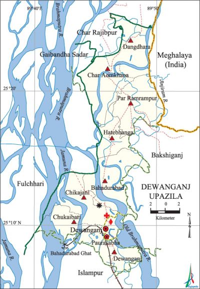
Dewanganj Upazila
Dewanganj Upazila (jamalpur district) area 267.51 sq km, located in between 25°06' and 25°26' north latitudes and in between 89°40' and 89°51' east longitudes. It is bounded by char rajibpur upazila on the north, islampur upazila on the south, bakshiganj upazila and Meghalaya state of India on the east, gaibandha sadar and fulchhari upazilas on the west.
Population Total 258133; male 126623, female 131510; Muslim 253927, Hindu 4064, Buddhist 2, Christian 3 and others 137.
Water bodies Main rivers: brahmaputra, old brahmaputra, jamuna, Jinjiram.
Administration Dewanganj Thana was formed in 1874 and it was turned into an upazila in 1983.
| Upazila | ||||||||
| Municipality | Union | Mouza | Village | Population | Density (per sq km) | Literacy rate (%) | ||
| Urban | Rural | Urban | Rural | |||||
| 1 | 8 | 42 | 166 | 46571 | 211562 | 965 | 38.1 (2001) | 30.6 |
| Municipality | ||||||||
|
Area |
Ward |
Mahalla |
Population |
Density |
Literacy rate | |||
| 20.65 (2001) | 9 | 43 | 38027 | 1733 (2001) | 42.6 | |||
| Upazila Town | ||||||||
|
Area |
Mouza |
Population |
Density |
Literacy rate | ||||
| 7.73 (2001) | 2 | 8544 | 1147 (2001) | 32.4 | ||||
| Union | ||||
| Name of union and GO code | Area (acre) | Population | Literacy rate (%) | |
| Male | Female | |||
| Char Aomkhaoa 29 | 8848 | 19146 | 20481 | 32.4 |
| Chikajani 36 | 6155 | 9744 | 9984 | 30.9 |
| Chukaibari 43 | 5253 | 3443 | 3750 | 29.0 |
| Dangdhara 51 | 11264 | 18045 | 19114 | 33.1 |
| Dewanganj 58 | 6051 | 10391 | 10217 | 33.1 |
| Par Ramrampur 87 | 9194 | 18133 | 18629 | 28.0 |
| Bahadurabad 17 | 10816 | 18696 | 18824 | 26.4 |
| Hatebhanga 65 | 6051 | 10455 | 11054 | 33.1 |
Source Bangladesh Population Census 2001 and 2011, Bangladesh Bureau of Statistics.

War of Liberation On 30 July 1971, a direct encounter was held between the freedom fighters and the Pak army at Bahadurabad Ghat. On the third day of the encounter the freedom fighters disrupted the railway communication via the Bahadurabad Ghat. Dewanganj was liberated on 9 December 1971. Mass graves have been discovered at three places of the upazila.
For details: see দেওয়ানগঞ্জ উপজেলা, বাংলাদেশ মুক্তিযুদ্ধ জ্ঞানকোষ (Encyclopedia of Bangladesh War of Liberation), বাংলাদেশ এশিয়াটিক সোসাইটি, ঢাকা ২০২০, খণ্ড ৪।
Religious institutions Mosque 322, temple 7.
Literacy rate and educational institutions Average literacy 32.5%; male 35.0%, female 30.1%. Educational institutions: college 3, secondary school 28, primary school 128, vocational school 3, satellite school 16, community school 2, kindergarten 12, madrasa 82. Noted educational institutions: AK Memorial College (1970), Dewanganj Government High School (1919), Sanandabari High School (1967).
Cultural organisations Library 30, club 20, cinema hall 3, theatre group 1, women and child welfare society 15, playground 31.
Main sources of income Agriculture 68.49%, non-agricultural labourer 5.28%, industry 0.27%, commerce 9.07%, transport and communication 1.75%, service 4.94%, construction 0.82%, religious service 0.17%, rent and remittance 0.08% and others 9.13%.
Ownership of agricultural land Landowner 48.40%, landless 51.60%; agricultural landowner: urban 34.41% and rural 52.10%.
Main crops Paddy, jute, wheat, mustard, sugarcane, potato, gram, masur, vegetables.'
Extinct or nearly extinct crops Peanut, kaun.
Main fruits Mango, banana, coconut, water-melon, futi.
Fisheries, dairies and poultries Cattle breeding centre 1, hatchery 1.
Communication facilities Pucca road 92 km, semi-pucca road 1 km, mud road 337 km; railway 8 km; waterway 20 km.
Extinct or nearly extinct traditional transport Palanquin.
Noted manufactories Sugar mill, oil mill, rice mill, ice cream factory.
Cottage industries Blacksmith, potteries, handicrafts, bamboo and wood work.
Hats, bazars and fairs Hats and bazars are 16, fairs 2, most noted of which are Sanandabari Hat, Char Magurihat, Beltali Bazar, Zhalur Char Bazar and Dewanganj Mela.
Main exports Jute, rice, mustard, potato.
Access to electricity All the wards and unions of the upazila are under rural electrification net-work. However 21.0% of the dwelling households have access to electricity.
Sources of drinking water Tube-well 94.6%, tap 0.2% and others 5.2%.
Sanitation 34.8% of dwelling households of the upazila use sanitary latrines and 47.8% of dwelling households use non-sanitary latrines; 17.4% of households do not have latrine facilities.
Health centres Upazila health complex 1, satellite clinic 2, family planning centre 8, community clinic 29, diagnostic centre 4.
NGO activities Operationally important NGOs are brac, asa. [Sayed Md Abdullah Al Mamun Chowdhury]
References Bangladesh Population Census 2001 and 2011, Bangladesh Bureau of Statistics; Cultural survey report of Dewanganj Upazila 2007.
