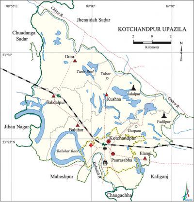
Kotchandpur Upazila
Kotchandpur Upazila (jhenaidah district) area 165.63 sq km, located in between 23°22' and 23°33' north latitudes and in between 88°55' and 89°06' east longitudes. It is bounded by jhenaidah sadar upazila on the north, maheshpur and chaugachha upazilas on the south, kaliganj (Jhenaidah) upazila on the east, chuadanga sadar and jibannagar upazilas on the west.
Population Total 141121; male 70585, female 70536; Muslim 126479, Hindu 14550, Buddhist 1 and others 91.
Water bodies Main rivers: chitra and kobadak; Baluhar Baor and Tanir Beel are notable.
Administration Kotchandpur Thana was formed in 1772 and it was turned into an upazila in 1983. Municipality was formed in 1883.
| Upazila | ||||||||
| Municipality | Union | Mouza | Village | Population | Density (per sq km) | Literacy rate (%) | ||
| Urban | Rural | Urban | Rural | |||||
| 1 | 5 | 74 | 79 | 33094 | 108027 | 852 | 62.3 | 46.8 |
| Municipality | ||||||||
|
Area (sq km) |
Ward |
Mahalla |
Population |
Density (per sq km) |
Literacy rate (%) | |||
| 17.04 | 9 | 25 | 33094 | 1942 | 62.3 | |||
| Union | ||||
| Name of union and GO code | Area (acre) | Population | Literacy rate (%) | |
| Male | Female | |||
| Elangi 40 | 6339 | 9558 | 9440 | 56.4 |
| Kushna 67 | 7761 | 12348 | 12560 | 44.1 |
| Dora 27 | 9164 | 10470 | 10688 | 40.0 |
| Baluhar 13 | 6671 | 10386 | 10256 | 46.5 |
| Sabdalpur 81 | 6584 | 11356 | 10965 | 48.1 |
Source Bangladesh Population Census 2011, Bangladesh Bureau of Statistics.
Archaeological heritage and relics Chand Khan Mazar (1656), Shivabari Mandir (1680), Rathkhola (seventeenth century), Kali Mandir (1820), Mohila College Building (1805), Jami Mosque (1884) at village Nagda, Jami Mosque (1885) at Barabamandaha, Ikhra Mandir (Fadilpur), Gambuj Mandir (Jalalpur), two-storied building of Tarin Datta and Nibaran Chanda (Kotchandpur bazar); brass made throne preserved at Shiva Mandir and three statues (Jagannath, Balaram and Subhadra) preserved at Jagannath Mandir.

Memorable event In 2006, a fighter plane of the Bangladesh Air Force was crushed at village Baharampur under Kushna union in which the pilot Taniul Alam was killed.
War of Liberation Kotchandpur was under sector 8 during the war of liberation and the freedom fighters had encounters with Pak army at Sabdalpur, Food Godown area, Bara Bamandaha, Swadi, Sherkhali and some other palces of the upazila.
For details: see কোটচাঁদপুর উপজেলা, বাংলাদেশ মুক্তিযুদ্ধ জ্ঞানকোষ (Encyclopedia of Bangladesh War of Liberation), বাংলাদেশ এশিয়াটিক সোসাইটি, ঢাকা ২০২০, খণ্ড ২।
Religious institutions Mosque 252, temple 20, tomb 3.
Literacy rate and educational institutions Average literacy 50.4%; male 52.7%, female 48.2%. Educational institutions: college 5, secondary school 19, primary school 37, madrasa 9. Noted educational institutions: Government Khandaker Musharraf Hossain Degree College (1969), Kotchandpur Poura Mohila College, Kotchandpur Pilot Secondary School (1899), Kotchandpur Secondary Girl's School.
Newspapers and periodicals Defunct: Unmesh (1975), Khanakal (1980), Kingshuk (1980), Ma (1980), Swadhinata Amar Swadhinata (1981), Kotchandpur Sahitya (1982), Agnishikha (1984), Dinamide (1984), Gitanga (1998), Sotomoni (1991).
Cultural organisations Library 1, club 23, community centre 5, press club 2.
Main sources of income Agriculture 64.03%, non-agricultural labourer 3.23%, industry 0.68%, commerce 15.95%, transport and communication 3.13%, service 5.32%, construction 1.69%, religious service 0.14%, rent and remittance 0.40% and others 5.43%.
Ownership of agricultural land Landowner 58.44%, landless 41.56%; agricultural landowner: urban 41.13% and rural 63.89%.Main crops Paddy, sugarcane, jute, pulse, wheat, cotton.
Extinct or nearly extinct crops Kaun, china, sesame, linseed, mesta (jute), tobacco, arahar, gram. Main fruits Mango, blackberry, jackfruit, guava, banana, palm, date, coconut.
Fisheries, dairies and poultries This upazila has a number of fisheries, poultries, artificial cattle breeding centre and hatcheries.
Communication facilities Pucca road 77 km, semi-pucca 64 km, mud road 413 km.
Extinct or nearly extinct traditional transport Palanquin, horse carriage, bullock cart.
Noted manufactories Rice mill, welding factory, saw mill, chocolate factory.
Cottage industries Manufacture of bullock cart wheel, brass work.
Hats, bazars and fairs Hats and bazars are 17, fairs 8, most noted of which are Kotchandpur, Sabdalpur, Elangi, Talsar, Gurpara, Jalalpur and Kushna hats, Baishakhi Mela, Rathkhola Mela, Kalitala Mela, Chaitra Samkranti Mela at Fadilpur.
Main exports Jute, sugarcane, rice, date molasses, pulse, mango.
Access to electricity All the wards and unions of the upazila are under rural electrification net-work. However 75.5% of the dwelling households have access to electricity.
Sources of drinking water Tube-well 95.5%, tap 3.4% and others 1.1%.
Sanitation 70.1% of dwelling households of the upazila use sanitary latrines and 25.5% of dwelling households use non-sanitary latrines; 4.4% of households do not have latrine facilities.
Health centres Upazila health centre 1, family welfare centre 2, mother and child welfare centre 3, clinic 5, union health and family welfare centre 2, satellite clinic 3, community clinic 11, veterinary hospital 1.
NGO activities Operationally important NGOs are brac, asa. [Md. Azizur Rahman]
References Bangladesh Population Census 2001 and 2011, Bangladesh Bureau of Statistics; Cultural survey report of Kotchandpur Upazila 2007.
