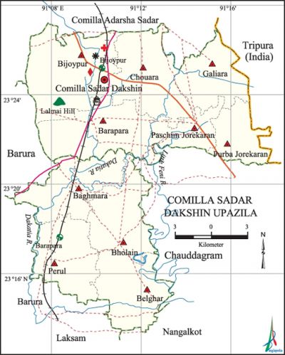
Comilla Sadar Dakshin Upazila
Comilla Sadar Dakshin Upazila (comilla district) area 241.66 km, located in between 23°13' and 23°27' north latitudes and in between 91°06' and 91°15' east longitudes. It is bounded by comilla adarsha sadar upazila on the north, laksham, chauddagram and nangalkot upazilas on the south, tripura state of India on the east, barura upazila on the west.
Population Total 354289; male 179744, female 174545.
Water bodies Main rivers: dakatia and little feni.
Administration Comilla Sadar Dakshin upazila was formed comprising 6 unions of Comilla Adarsha Sadar Upazila and 4 unions on Laksham upazila on 4 April 2005.
| Upazila | ||||||||
| Municipality | Union | Mouza | Village | Population | Density (per sq km) | Literacy rate (%) | ||
| Urban | Rural | Urban | Rural | |||||
|
1 |
10 |
364 |
459 |
- |
354289 |
1466 |
- |
45.90 |
| Union | ||||
| Name of union and GO code | Area (acre) | Population | Literacy rate (%) | |
| Male | Female | |||
|
Galiara 58 |
5501 |
15781 |
15577 |
44.26 |
|
Chouara 39 |
7307 |
19425 |
18423 |
55.04 |
|
Paschim Jorekaran 80 |
3624 |
10572 |
9979 |
39.00 |
|
Purba Jorekaran 73 |
4038 |
9654 |
10034 |
37.77 |
|
Perul 80 |
6341 |
17388 |
18212 |
45.94 |
|
Baghmara 12 |
6975 |
19031 |
19014 |
45.34 |
|
Bara Para 24 |
8575 |
19833 |
19118 |
47.12 |
|
Bijoypur 31 |
5110 |
30878 |
27385 |
58.06 |
|
Belghar 28 |
6681 |
19888 |
19794 |
46.46 |
|
Bholain 31 |
6263 |
17294 |
17009 |
40.08 |
Source Bangladesh Population Census 2001, Bangladesh Bureau of Statistics.
Archaeological heritage and relics Bara Gambuj Mosque at Kaneshtala, Alishwar Buddhist Temple.
History of the War of Liberation In the month of July 1971 an encounter occurred between the freedom fighters and the Pak army at village Madaripur of the upazila in which a number of freedom fighters and Pak army were killed and wounded. Besides, the Pak army set fire to a number of homesteads and killed 5-7 innocent villagers.

Literacy rate and educational institutions Average literacy 45.90%; male 48.63%, female 43.15%. Educational institutions: college 9, secondary school 53, primary school 158, madrasa 56. Noted Educational institution: Chouara Adarsha Degree College (1972).'
Tourist spots lalmai hills.
Main sources of income Agriculture 51.19%, non-agricultural labourer 3.06%, industry 0.88%, commerce 13.17%, transport and communication 5.08%, service 11.41%, construction 1.92%, religious service 0.32%, rent and remittance 1.99% and others 10.98%.
Ownership of agricultural land Landowner 61.11%, landless 38.89%.
Main crops Paddy, wheat, sugarcane, vegetables.
Extinct or nearly extinct crops Jute, sunflower, ground nut, kaun, linseed, arahar.
Main fruits Mango, coconut, banana, jackfruit.
Communication facilities Roads: pucca 324.16 km, mud road 501.85 km.
Extinct or nearly extinct traditional transport Palanquin, horse carriage, bullock cart.
Noted cottage industries Goldsmith, blacksmith, potteries, bamboo and cane work.
Main export Flour, vegetables.
Access to electricity All the wards and unions of the upazila are under rural electrification net-work; however 62.42% dwelling households have access to electricity.
Sources of drinking water Tube-well 90.71%, pond 1.14%, tap 1.68% and others 6.47%.
Sanitation 54.97% of dwelling households of the upazila use sanitary latrines and 31.43% of dwelling households use non-sanitary latrines; 13.60% of households do not have sanitation facilities.
Health centres Upazila health complex 1, hospital 2.
NGO activities brac, asa, Aid, Palli Pragati Prakalpa. [Yasin Ashraf]
References Bangladesh Population Census 2001, Bangladesh Bureau of Statistics; Cultural survey report of Comilla Sadar Dakshin Upazila 2007.
