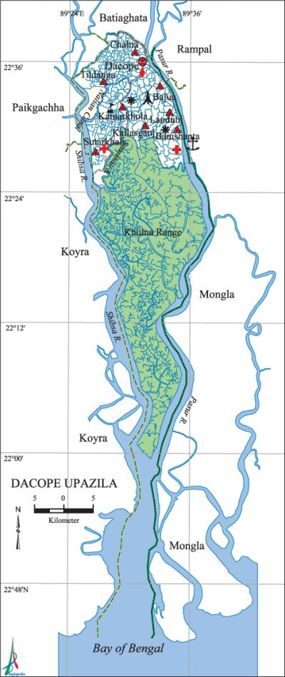
Dacope Upazila
Dacope Upazila (khulna district) area 991.57 sq km, located in between 22°24' and 22°40' north latitudes and in between 89°24' and 89°35' east longitudes. It is bounded by batiaghata upazila on the north, pasur river on the south, rampal and mongla upazilas on the east, paikgachha and koyra upazilas on the west.
Population Total 157489; male 83193, female 74296; Muslim 65756, Hindu 88842, Buddhist 2760 and others 131.
Water bodies Main rivers: Pasur, shibsa, Manki, bhadra; Palashbari, Churia, Nalian and Jugra canals are notable.
Administration Dacope Thana was formed on 10 February 1906 and it was turned into an upazila in 1983.
| Upazila | ||||||||
| Municipality | Union | Mouza | Village | Population | Density (per sq km) | Literacy rate (%) | ||
| Urban | Rural | Urban | Rural | |||||
|
- |
10 |
26 |
107 |
19804 |
137685 |
159 |
54.71 |
48.57 |
| Upazila Town | ||||||||
|
Area |
Mouza |
Population |
Density |
Literacy rate (%) | ||||
|
22.00 |
1 |
19804 |
900 |
54.71 | ||||
| Union | ||||
| Name of union and GO code | Area (acre) | Population | Literacy rate (%) | |
| Male | Female | |||
|
Kamarkhola 63 |
7214 |
6944 |
6375 |
50.53 |
|
Kailasganj 52 |
7214 |
7546 |
7204 |
58.63 |
|
Khulna Range 97 |
197438 |
4096 |
198 |
1.37 |
|
Chalna 31 |
11093 |
15330 |
14444 |
53.05 |
|
Tildanga 84 |
11027 |
9403 |
8567 |
51.45 |
|
Dacope 42 |
4101 |
3749 |
3531 |
56.61 |
|
Bajua 10 |
7555 |
7839 |
7180 |
54.00 |
|
Banishanta 13 |
6954 |
8220 |
7904 |
47.41 |
|
Laudubi 21 |
3313 |
4403 |
4126 |
51.64 |
|
Sutarkhali 73 |
12092 |
15663 |
14767 |
43.24 |
Source Bangladesh Population Census 2001, Bangladesh Bureau of Statistics.

Marks of the War of Liberation Mass killing site 1 (Bajua High School premises); memorial monument 1 (Smriti Amlan).
Religious institutions Mosque 72, temple 137, church 11, sacred place 2.'
Literacy rate and educational institutions Average literacy 46.66%; male 53.89%, female 38.98%. Educational institutions: college 6, secondary school 31, primary school 56, NGO school 43, madrasa 5. Noted educational institutions: Surendranath College (1972), Chalna MM College (1984), Sreenagar ME Secondary School (1817), Bajua Union High School (1920), Chalna Government KC Primary School (1947), Bajua Government Primary School (1947).
Newspapers and periodicals Alochhaya, Barsa, Padakkep, Prayas.
Cultural organisations Club 40, library 2, theatre group 1, opera party 1, women's organisation 1.
Special attractions The sundarbans (located on the southern part of the upazila), Crocodile breeding centre, Watch Tower.
Main sources of income Agriculture 66.07%, non-agricultural labourer 4.85%, commerce 12.86%, transport and communication 1.72%, service 4.10%, construction 0.93%, religious service 0.24%, rent and remittance 0.05% and others 9.18%.
Ownership of agricultural land Landowner 55.02%, landless 44.98%; agricultural landowner: urban 42.04% and rural 57.06%.
Main crops Paddy, potato, pumpkin, vegetables.
Extinct or nearly extinct crops Jute, sesame, aush and boro paddy.
Main fruits Coconut, guava, plum, sofeda, bangi, watermelon.
Fisheries, dairies and poultries In this upazila shrimp cultivation are done in an extended form.
Communication facilities Roads: pucca 18 km, semi-pucca 92 km, mud road 275.67 km.
Extinct or nearly extinct traditional transport Palanquin, bullock cart, horse carriage.
Noted manufactories Fish processing factory, rice mill, salt production centre.
Cottage industries Goldsmith, blacksmith, potteries, bamboo work, cane work.
Noted hats, bazars and fairs' Chalna Hat, Bajua Hat, Pankhali Hat, Poddarganj Hat, Bajua Bijoya Dashmir Mela, Baruni Mela and Mela on the occasion of the birth celebration of Sri Sri Anukul Chandra.
Main exports Frozen shrimp and crab.
Access to electricity All the unions of the upazila are under rural electrification net-work. However 6.35% dwellings have access to electricity.'
Sources of drinking water Tube-well 39.78%, pond 54.06%, tap 3.15% and others 3.01%.
Sanitation 38.83% (urban 71.75% and rural 33.66%) of dwelling households of the upazila use sanitary latrines and 48.70% (urban 21.17% and rural 53.02%) of dwelling households use non-sanitary latrines; 12.44% of households do not have latrine facilities.
Health centres Hospital 1, family welfare centre 3, health and family planning centre 9, mother and child welfare centre 1.
NGO activities proshika, World Vision, Gonoshahajjo Sangstha, HEED Bangladesh, brac, Step, Prodipon, Vost, ESDO. [Shah Siddiqi]
References Bangladesh Population Census 2001, Bangladesh Bureau of Statistics; Cultural survey report of Dacope Upazila 2007.
