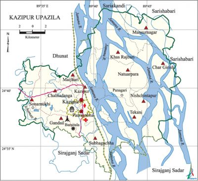
Kazipur Upazila
Kazipur Upazila (sirajganj district) area 368.63 sq km, located in between 24°32' and 24°46' north latitudes and in between 89°32' and 89°48' east longitudes. It is bounded by dhunat, sariakandi and sarishabari upazilas on the north, sirajganj sadar upazila on the south, Sarishabari upazila and the jamuna river on the east, Dhunat upazila on the west. Many old inhabitation including Mallickpara, Dhulaura, Maijbari, Manik Patal, Kazipur, Meghai, Tarakandi, Tengalahata are gradually getting extinct by river erosions.
Population Total 266950; male 136056, female 130894; Muslim 260646, Hindu 6286 and others 18.
Water bodies Main river: Jamuna.
Administration Kazipur Thana was formed in 1920 and it was turned into an upazila in 1984.
| Upazila | ||||||||
| Municipality | Union | Mouza | Village | Population | Density (per sq km) | Literacy rate (%) | ||
| Urban | Rural | Urban | Rural | |||||
|
1 |
12 |
114 |
154 |
27835 |
266950 |
724 |
46.2 |
37.3 |
| Municipality | ||||||||
|
Area (sq km) |
Ward |
Mahalla |
Population |
Density |
Literacy rate (%) | |||
|
8.49 |
9 |
9 |
13589 |
1601 |
50.20 | |||
| Upazila Town | ||||||||
|
Area (sq km) |
Mouza |
Population |
Density |
Literacy rate | ||||
|
8.70 |
3 |
14246 |
1637 |
42.33 | ||||
| Union | ||||
| Name of union and GO code | Area (acre) | Population | Literacy rate (%) | |
| Male | Female | |||
|
Kazipur 34 |
6786 |
8050 |
8047 |
42.61 |
|
Khas Rajbari 43 |
9042 |
7415 |
6807 |
34.50 |
|
Gandail 25 |
6224 |
14755 |
14715 |
41.97 |
|
Char Girish 15 |
7949 |
18437 |
17666 |
45.63 |
|
Chalitadanga 17 |
7047 |
17353 |
17027 |
31.08 |
|
Tekani 94 |
8625 |
6939 |
6657 |
42.61 |
|
Natuarpara 60 |
7640 |
6759 |
6582 |
37.53 |
|
Nishchintapur 69 |
8983 |
10763 |
10465 |
29.87 |
|
Mansurnagar |
8460 |
8384 |
6077 |
24.32 |
|
Maijbari 51 |
4876 |
5991 |
5786 |
35.49 |
|
Subhagachha 86 |
7085 |
7998 |
8121 |
45.87 |
|
Sonamukhi 77 |
6683 |
16386 |
16181 |
31.92 |
Source Bangladesh Population Census 2001, Bangladesh Bureau of Statistics.
History of the War of Liberation In 1971 the Pak army conducted mass killing and plundering at different places of the upazila; they also set many houses on fire. In December 1971, a battle was fought between the Pak army and the freedom fighters at village Baraitala of Gandail union in which several freedom fighters lost their lives.

Marks of the War of Liberation Mass grave 1 (Baraitala); memorial monument 1.
Religious institutions Mosque 231, temple 45, tomb 3.
Literacy rate and educational institutions Average literacy 20.5%; male 26.3%, female 14.5%. Educational institutions: college 12, secondary school 51, primary school 216, madrasa 10. Noted Educational institutions: Kazipur Government Mansur Ali College, Natuarpara Degree College,' Kazipur Mahila College, Meghai UUI Multilateral High School (1919), Meghai High School (1920), Gandhail High School (1920), Rani Dinamoni High School (1957), Kazipur Government Girls' High School, Sonamukhi Senior Fazil Madrasa.
Cultural organisations Library 1, club 32, playground 12.
Main sources of income Agriculture 67.44%, non-agricultural labourer 1.96%, industry 1.72%, commerce 11.31%, transport and communication 1.71%, service 6.75%, construction 2.55%, religious service 0.19%, rent and remittance 0.15% and others 6.22%.
Ownership of agricultural land Landowner 68.53%, landless 31.87%; agricultural landowner: urban 60.42% and rural 69.56%.'
Main crops Paddy, jute, wheat, pulse, chilli, mustard, linseed,' tobacco, vegetables.
Extinct or nearly extinct crops Aus 'paddy.
Main fruits Mango, blackberry, jackfruit, papaya, guava, coconut, litchi, banana.
Fisheries, dairies and poultries This upazila has a number of fisheries, dairies, poultries, hatcheries and artificial breeding centre.
Communication facilities Pucca road 45.54 km, mud road 227.37 km; waterway 5 nautical miles. Culvert 241, bridge 107.
Extinct or nearly extinct traditional transport Palanquin, dhuli, horse carriage.
Cottage industries Blacksmith, weaving.
Hats, bazars and fairs Hats and bazars are 37, fairs 3, most noted of which are Natuarpara, Sonamukhi, Harinathpur, Bhanudanga, Chalitadanga, Mathail Chapar, Gandail and Panagari hats and Sonamukhi Mela.
Main exports Paddy, jute, chilli, mustard.
Access to electricity All the wards and unions of the upazila are under rural electrification net-work. However 10.46% of the dwelling households have access to electricity.
Sources of drinking water Tube-well 95.03%, tap 0.33%, pond 0.15% and others 4.49%.
Sanitation 33.16% (rural 32.09% and urban 41.56%) of dwelling households of the upazila use sanitary latrines and 55.83% (rural 56.83% and urban 47.97%) of dwelling households use non-sanitary latrines; 11.01% of households do not have latrine facilities.
Health centres Upazila health complex 1, health centre 9, clinic 1, union health and family welfare centre 11, veterinary hospital 1.
Natural disasters A large number of people were victims of the famines of 1897, 1943 and 1974. Besides, the earthquakes of 1885 and 1897 caused heavy damages to settlements and other properties of the upazila.'
NGO activities Operationally important NGOs are brac, proshika, TMSS, Ujjiban. [Rafiqul Islam]
References Bangladesh Population Census 2001, Bangladesh Bureau of Statistics; Cultural survey report of Kazipur Upazila 2007.
