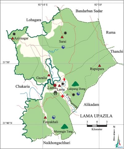
Lama Upazila
Lama Upazila (bandarban district) area 671.84 sq km, located in between 21°36' and 21°59' north latitudes and in between 92°04' and 92°23' east longitudes. It is bounded by bandarban sadar and lohagara (chittagong) upazilas on the north, naikhongchhari and alikadam upazilas on the south, ruma, thanchi and Alikadam upazilas on the east, chakaria upazila on the west. Lakpang Dang and Muranga Tang Hills of the upazila are notable.
Population Total 78488; male 41693, female 36795; Muslim 55349, Hindu 2434, Buddhist 4966, Christian 15429 and others 310.
Water bodies Main river: matamuhuri.
Administration Lama Thana was formed in 1923 and it was turned into an upazila in 1985.
Upazila |
||||||||
Municipality |
Union |
Mouza |
Village |
Population |
Density |
Literacy rate (%) |
||
Urban |
Rural |
Urban |
Rural |
|||||
- |
6 |
18 |
355 |
13955 |
64533 |
117 |
45 |
27.2 |
Upazila Town |
||||||||
Area (sq km) |
Mouza |
Population |
Density |
Literacy rate |
||||
41.44 |
1 |
13955 |
337 |
44.99 |
||||
Union |
||||||||
Name of union and GO code |
Area |
Population |
Literacy rate |
|||||
Male |
Female |
|||||||
Aziznagar 15 |
23680 |
9359 |
8108 |
35.56 |
||||
Gajalia 47 |
30720 |
4555 |
4055 |
23.71 |
||||
Fasyakhali 31 |
47360 |
8810 |
7859 |
26.79 |
||||
Rupshipara 68 |
22400 |
4437 |
4062 |
20.90 |
||||
Lama 63 |
18560 |
9967 |
8739 |
39.61 |
||||
Sarai 79 |
23040 |
4565 |
3972 |
22.33 |
||||
Source Bangladesh Population Census 2001, Bangladesh Bureau of Statistics.

History of the War of Liberation During the war of liberation Lama upazila was under Sector 1. The Pak army conducted mass killing and heavy plundering; they also set many houses of the upazila on fire.
Religious institutions Mosque 35, temple 5, church 15, keyang 18.
Literacy rate and educational institutions Average literacy 30.4%; male 36.4%, female 23.5%. Educational institutions: college 1, secondary school 6, primary school 74, community school 5, madrasa 4. Noted educational institutions: Lama Government High School, Chambi High School,' Lama Adarsha Primary School, Ramthui Para Government Primary School, Linejhiri Government Primary School.
Cultural organisations Library 2, music academy 1, auditorium 1, cinema hall 1, playground 3.
Tourists spots Merenga, Memorial Christan Mission.
Main sources of income Agriculture 62.18%, non-agricultural labourer 7.4%, industry 0.46%, commerce 10.82%, transport and communication 0.61%, service 7.52%, construction 0.6%, religious service 0.27%, rent and remittance 0.31% and others 9.83%.
Ownership of agricultural land Landowner 50.09%, landless 49.91%; agricultural landowner: urban 37.12% and rural 52.74%.
Main crops Paddy, tobacco, potato, ginger, nut, turmeric, sesame, cotton, vegetables.
Main fruits Banana, jackfruit, litchi, papaya.
Fisheries, dairies and poultries Poultry 1.
Noted manufactories Rice mill, match factory, saw mill.
Cottage industries Weaving, wood work, bamboo and cane work.
Hats, bazars and fairs Hats and bazars are 5, most noted of which are Lama Bazar, Gajalia Bazar, Kiajupara Bazar, Rupasi Bazar and Aziznagar Bazar.
Main exports Banana, jackfruit, bamboo, cotton, sesame, ginger, yarn, turmeric.
Access to electricity All the unions of the upazila are under rural electrification net-work. However 11.23% of the dwelling households have access to electricity.
Sources of drinking water Tube-well 53.87%, tap 0.41%, pond 7.9% and others 37.82%.
Sanitation 10.57% (rural 6.78% and urban 29.19%) of dwelling households of the upazila use sanitary latrines and 55.33% (rural 56.11% and urban 51.52%) of dwelling households use non-sanitary latrines; 34.1% of households do not have latrine facilities.
Health centres Upazila health complex 1, satellite clinic 3, veterinary hospital 1.
NGO activities Operationally important NGOs are brac, asa, proshika. [Atikur Rahman]
References Bangladesh Population Census 2001, Bangladesh Bureau of Statistics; Cultural survey report of Lama Upazila 2007.
