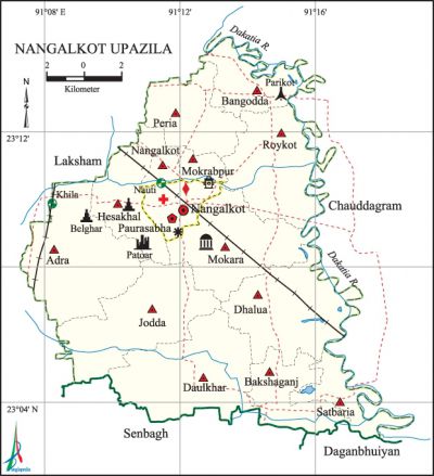
Nangalkot Upazila
Nangalkot Upazila (comilla district) area 236.44 sq km, located in between 23°02' and 23°14' north latitudes and in between 91°'07' and 91°18' east longitudes. It is bounded by laksham and chauddagram upazilas on the north, senbagh and daganbhuiyan upazilas on the south, Chauddagram upazila on the east, Laksham upazila on the west.
Population Total 319782; male 156558, female 163224; Muslim 315364, Hindu 4373, Buddhist 9, Christian 14 and others 22.
Water bodies Main river: dakatia.
Administration Nangalkot Thana was turned into an upazila in 1983.
| Upazila | ||||||||
| Municipality | Union | Mouza | Village | Population | Density (per sq km) | Literacy rate (%) | ||
| Urban | Rural | Urban | Rural | |||||
|
- |
11 |
213 |
289 |
6264 |
313518 |
1352 |
45.82 |
40.50 |
| Upazila Town | |||||||||
|
Area (sq km) |
Mouza |
Population |
Density (per sq km) |
Literacy rate (%) | |||||
|
3.25 |
3 |
6264
|
1927
|
45.82 | |||||
| Union | ||||
| Name of union and GO code | Area (acre) | Population | Literacy rate (%) | |
| Male | Female | |||
|
Adra 08
|
7149
|
18525
|
19090
|
39.14
|
|
Jodda 60
|
6613
|
16815
|
18113
|
39.34
|
|
Dhalua 43
|
6328
|
13829
|
13734
|
39.05
|
|
Daulkhar 51
|
7126
|
17018
|
18743
|
39.51
|
|
Nangalkot 77
|
7369
|
22821
|
22648
|
41.47
|
|
Peria 80
|
3575
|
11284
|
12034
|
39.50
|
|
Bakshaganj 34
|
3327
|
9385
|
10653
|
39.20
|
|
Bangodda 17
|
3099
|
10017
|
9996
|
39.57
|
|
Mokara 69
|
16227
|
16538
|
43.37
|
45.88
|
|
Roykot 86
|
5724
|
16530
|
17863
|
41.62
|
|
Satbaria 94
|
2271
|
4107
|
3812
|
51.68 |
Source Bangladesh Population Census 2001, angladesh Bureau of Statistics.

Archaeological heritage and relics Old Kella (fort) at Patoari Dighi.
History of the War of Liberation During the war of liberation Nangalkot upazila was under Sector 2. The Pak army killed 11 innocent persons at Tejer Bazar of the upazila. Besides, the local razakars killed one freedom fighter openly and buried him at a place near the Hasanpur Railway Station.
Marks of the War of Liberation Memorial monument 2, mass grave 2 (Parikot 'and Tejer Bazar).
Religious institutions Mosque 650, temple 6. Noted religious institutions: Nangalkot Bara Mosque, Jami Mosque at Khandkar Bari, Mokara Shahi Jami Mosque, Tilip Jami Mosque, Shree Shree Kali Mandir at Hesakhal, Belghar Mandir, Ohiajora Kali Mandir.
Literacy rate and educational institutions Average literacy 40.61%; male 42.17%, female 39.18%. Educational institutions: college 9, technical college 3, secondary school 43, primary school 131, satellite primary school 39, madrasa 34. Noted educational institutions: Hasan Memorial Degree College (1984), Chalan College (1985), Homnabad Model College (1985), Bholain College (1995), Mayura' High School (1916), Daulkhar High School (1929), Nangalkot AR Multilateral High School (1941), Autistic School (1988),' Badsha Mia High School, Mandali High School, Shaktali High School, Patoari Senior Madrasa, Nangalkot AU Kalim Madrasa.
Newspapers and periodicals Weekly: Nangalkot Barta (irregular).
Cultural organisations Library 3, club 102, playground 10, theatre stage 1.
Main sources of income Agriculture 45.72%, non-agricultural labourer 3.15%, industry 0.79%, commerce 12.54%, transport and communication 2.91%, service 14.39%, construction 1.42%, religious service 0.46%, rent and remittance 8.42% and others 10.20%.
Ownership of agricultural land Landowner 63.13%, landless 36.87%; agricultural landowner: urban 60.07% and rural 63.19%.
Main crops Paddy, wheat, potato, maize, kalai, vegetables.
Extinct or nearly extinct crops Sesame, linseed, kaun, mulberry, betel leaf, arahar.
Main fruits Mango, jackfruit, litchi, banana, pineapple, watermelon, kamranga.
Fisheries, dairies and poultries Hatchery and fish marketing centre 11, poultry 10, nursery 11, cattle breeding centre 15.
Communication facilities Pucca road 140 km, semi-pucca road 20 km, mud road 540 km; railway 26 km; culvert 724, bridge 23.
Extinct or nearly extinct traditional transport Palanquin, bullock cart, horse carriage.
Noted manufactories Rice mill, ice factory, brick-field.
Cottage industries Goldsmith, blacksmith, potteries, weaving, embroidery, wood work, bamboo work, cane work.
Hats, bazars and fairs Hats and bazars are 40, fairs 4, most noted of which are Nangalkot Bazar, Omarganj Bazar, Charia Bazar, Boxganj Bazar, Jodda Daulkhar Bazar, Dhalua Bazar, Mahini Bazar, Hesakhal Bazar, Dayemchadi Bazar and Paush Samkranti Mela at Mokara Village, Baishakhi Mela at Azizia.
Access to electricity All the unions of the upazila are under rural electrification net-work. However 22.95% of the dwelling households have access to electricity.
Sources of drinking water Tube-well 88.16%, tap 0.93%, pond 2.71% and others 8.21%. The presence of arsenic has been detected in shallow tube-well water of the upazila.
Sanitation 55.35% (rural 54.90% and urban 77.55%) of dwelling households of the upazila use sanitary latrines and 31.37% (rural 31.74% and urban 12.87%) of dwelling households use non-sanitary latrines; 13.28% of households do not have latrine facilities.
Health centres Hospital 2, family planning centre 11, satellite clinic 3, community health centre 42, EPI centre 24, clinic 2, mental hospital 1, mother and child welfare centre 1.
Natural disasters The floods of 1958, 1998 and 2002 inundated the vast area and also caused heavy damages to settlements, communication and crops of the upazila.'
NGO activities Operationally important NGOs are brac, asa, Manab Kalyan Sangstha. [Md. Mobashwer Hussain]
References Bangladesh Population Census 2001, Bangladesh Bureau of Statistics; Cultural survey report of Nangalkot Upazila 2007.
