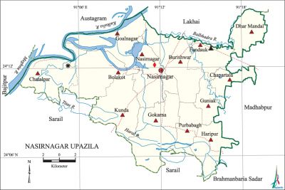
Nasirnagar Upazila
Nasirnagar Upazila (brahmanbaria district) area 311.66 sq km, located in between 24°05' and 24°16' north latitudes and in between 91°02' and 91°20' east longitudes. It is bounded by lakhai and austagram upazilas on the north, sarail and brahmanbaria sadar upazilas on the south, madhabpur upazila on the east, bajitpur and Austagram upazilas on the west.
Population Total 255668; male 128025, female 127643; Muslim 206435, Hindu 49027, Buddhist 25, Christian 11 and others 170.
Water bodies Main rivers: meghna, titas, Kulkulia, Haral, Balbhadra.
Administration Nasirnagar Sub-division was formed in 1860 and it was renamed as' Brahmanbaria Sub Division in 1875. Nasirnagar Thana was formed in 1910 and it was turned into an upazila on 1 August 1983.
| Upazila | ||||||||
| Municipality | Union | Mouza | Village | Population | Density (per sq km) | Literacy rate (%) | ||
| Urban | Rural | Urban | Rural | |||||
|
- |
13 |
100 |
129 |
12899 |
242769 |
820 |
36.18 |
27.36 |
| Upazila Town | ||||||||
|
Area (sq km) |
Mouza |
Population |
Density (per sq km) |
Literacy rate (%) | ||||
|
18.22 |
2 |
12899 |
708 |
36.18 | ||||
| Union | ||||
| Name of union and GO code | Area (acre) | Population | Literacy rate (%) | |
| Male | Female | |||
|
Kunda 80 |
7237 |
10531 |
10555 |
23.51 |
|
Guniak 65 |
2908 |
5638 |
5572 |
21.46 |
|
Gokarna 58 |
9566 |
13837 |
14071 |
28.48 |
|
Goalnagar 51 |
6016 |
7448 |
6926 |
25.91 |
|
Chatalpar 29 |
5839 |
17243 |
17291 |
30.68 |
|
Chapartala 21 |
3078 |
6337 |
6357 |
21.49 |
|
Dhar Mandal 36 |
4270 |
7441 |
7835 |
22.18 |
|
Nasirnagar 87 |
7121 |
11380 |
11406 |
32.98 |
|
Purbabagh 90 |
4125 |
7657 |
7512 |
23.80 |
|
Fandauk 43 |
4324 |
6854 |
6874 |
33.94 |
|
Bolakot 07 |
7639 |
11359 |
11142 |
30.28 |
|
Burishwar 14 |
8240 |
13057 |
12881 |
25.80 |
|
Haripur 73 |
4415 |
9243 |
9221 |
32.59 |
Source Bangladesh Population Census 2001, Bangladesh Bureau of Statistics.

Archaeological heritage and relics Jagannath Mandir (1917), Hindu Mandir at Fandauk (Mughal period), Remnants of Zamindar Bari at Haripur, embraced statue of Uma and Maheshwar (preserved in the National Museum, Dhaka).
History of the War of Liberation On 15 November 1971, the Pak army brutally killed a number of people of different villages under Kunda, Gokarna, Bolakot and Nasirnagar unions. An encounter was held between the freedom fighters and the Pak army at Bat-tala of village Tullapara in which 17 Pak soldiers including one razakar were killed. In another encounter with the Pak army at village Fulbaria one freedom fighter was killed.
Religious institutions Mosque 298, temple 39, tomb 4. Noted religious institutions: Kahetura Mosque, Nurpur Barrobari Mosque, Guniak Bazar Jami Mosque, Khandura Mazar Sharif, Fandauk Dargah Sharif, Kachua Darbar Sharif, Dantmandal Ajijia Darbar Sharif, Fandauk Mandir, Jagannath Mandir, Gaur Mandir, Gopinath Jeu Mandir.
Literacy rate and educational institutions Average literacy 27.8%; male 32.1%, female 23.7%. Educational institutions: college 2, secondary school 15, primary school 115, madrasa 7. Noted educational institutions: Nasirnagar College (1987), Guniak High School (1897), Chatalpar Wazuddin High School (1902), Fandauk Pandit Ram High School (1919), Nasirnagar Ashutosh Pilot High School (1945), Dantmandal Erfania Alim Madrasa (1950).
Newspapers and periodicals Nasirnagar Barta; quaterly: Siri.
Cultural organisations Library 3, club 1, community centre 1, cinema hall 2.
Main sources of income Agriculture 71.81%, non-agricultural labourer 3.44%, industry 0.60%, commerce 11.95%, transport and communication 1.34%, service 2.82%, construction 0.66%, religious service 0.39, rent and remittance 0.96% and others 6.03%.
Ownership of agricultural land Landowner 64.40%, landless 35.60%; agricultural landowner: urban 51.98% and rural 65.06%.
Main crops Paddy, jute, mustard, wheat, betel leaf, pulse, vegetables.
Extinct or nearly extinct crops Sesame, linseed, kaun, arahar, mug, masuri.
Main fruits Mango, jackfruit, blackberry, banana, papaya.
Fisheries, dairies and poultries This upazila has a number of fisheries, dairies and poultries.
Communication facilities Pucca road 58 km, semi-pucca road 10 km, mud road 167 km; waterway 18 nautical miles.
Extinct or nearly extinct traditional transport Palanquin, horse carriage, bullock cart.
Noted manufactories Rice mill, flour mill, ice factory, saw mill, welding factory.
Cottage industries Blacksmith, potteries, weaving, bamboo and cane work.
Hats, bazars and fairs Hats and bazars are 26, fairs 13, most noted of which are Nasirnagar Bazar, Fandauk Bazar, Chatalpar Bazar, Harinber Bazar, Baishakhi Mela at Kulikunda, Kartik Mela at Bolakot, Austami Snan Mela at Fandauk, Sidheshari Mela at Gokarna, Shutki Mela at Kulikunda.
Main exports Paddy, jute, betel leaf, dried fish, mustard.
Access to electricity All the unions of the upazila are under rural electrification net-work. However 9.69% of the dwelling households have access to electricity.
Sources of drinking water Tube-well 95.65%, pond 1.46%, tap 0.59% and others 2.30%.
Sanitation 17.39% (rural 15.85% and urban 46.66%) of dwelling households of the upazila use sanitary latrines and 75.05% (rural 76.56% and urban 47.21%) of dwelling households use non-sanitary latrines; 7.52% of households do not have latrine facilities.
Health centres Upazila health complex 1, rural health centre 1, satellite clinic 3, union family welfare centre 11.
Natural disasters The cyclone of 1971 devastated Chapartala and Chitna villages; besides, the floods of 1974 and 1988 caused heavy damages to settlements and other properties of this region.
NGO activities Operationally important NGOs are brac, asa, Save the Children, proshika. [Md. Abul Kasem Bhuiyan]
References Bangladesh Population Census 2001, Bangladesh Bureau of Statistics; Cultural survey report of Nasirnagar Upazila 2007.
