Sarankhola Upazila
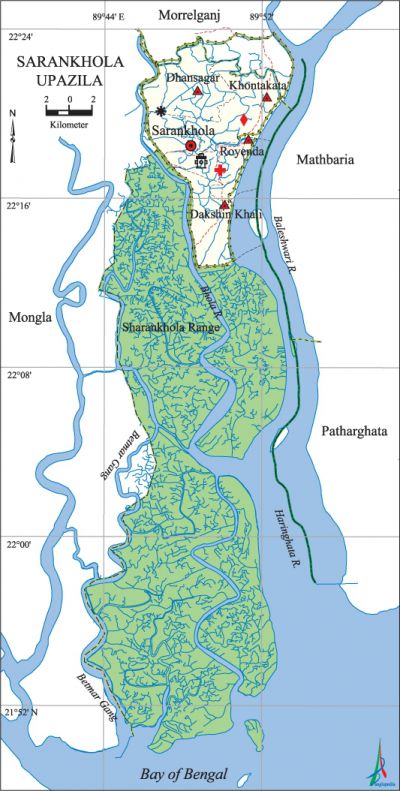
Sarankhola Upazila (bagerhat district) area 756.61 sq km, located in between 22°13' and 22°24' north latitudes and in between 89°46' and 89°54' east longitudes. It bounded by morrelganj upazila on the north, the bay of bengal on the south, mathbaria and patharghata upazilas on the east, mongla upazila on the west.
Population Total 114083; male 61799, female 52284; Muslim 101981, Hindu 12056, Buddhist 15 and others 31.
Water bodies Main rivers: Baleshwari, Haringhata, Bhola; Betmar Gang is notable.
Administration Sarankhola Thana, now an upazila, was formed in 1907. A major part of the upazila belongs to the sundarbans.
| Upazila | ||||||||
| Municipality | Union | Mouza | Village | Population | Density (per sq km) | Literacy rate (%) | ||
| Urban | Rural | Urban | Rural | |||||
|
- |
4 |
12 |
45 |
23547 |
90536 |
151 |
58.9 |
55.3 |
| Upazila Town | ||||||||
|
Area (sq km) |
Mouza |
Population |
Density (per sq km) |
Literacy rate (%) | ||||
|
29.08 |
2 |
23547 |
810 |
58.9 | ||||
| Union | ||||
| Name of union and GO code | Area (acre) | Population | Literacy rate (%) | |
| Male | Female | |||
|
Khontakata 38 |
9537 |
14325 |
14302 |
63.40 |
|
Dhansagar 19 |
8647 |
10136 |
9755 |
60.29 |
|
Royenda 57 |
9953 |
14744 |
15044 |
56.05 |
|
Dakshin Khali 76 |
9234 |
11939 |
12151 |
54.75 |
|
Sarankhola Range 97 |
146925 |
10655 |
1032 |
37.51 |
Source Bangladesh Population Census 2001, Bangladesh Bureau of Statistics.

Archaeological heritage and relics Mohini Kutir of Sinha Bari at village Amragachhia; Haji Sundar Mollah Dafadar Bari Jami Mosque (1882); Uttar Khontakata Nolemia Jami Mosque (1898), Dhansagar Mollah Bari Jami Mosque (1905).
Historical events In 1965 embankments through the rivers were constructed to save the region from extreme salinity; besides, the mouth of all the canals were blocked for the same purpose. However, as a result water loggings became evident in the region resulting into damages to crops. Having failed to get any help from the government the local peasants revolted and on 10 March 1969 they dismantled the embankments on Bayenda, Tafalbari, Khontakata and Kumarkhali canals all on a sudden. During the war of liberation in 1971 the Pak army killed about more than one hundred people by brush fire at Tarabaka canal. Direct encounters between the freedom fighters and the Pak army were held in different places including at Royenda Bazar. On 21 October, a fierce battle was held between the freedom fighters and the Pak army at Bogi.
Religious institutions Mosque 219, temple 72. Noted religious institutions: Haji Sundar Mollah Dafadar Bari Jami Mosque (1882), Uttar Khontakata Nolemia Jami Mosque (1898), Dhansagar Mollah Bari Jami Mosque (1905), Dhansagar Radha Govinda Mandir, Amragachhia Kali Mandir, Royenda Shitala Kali Mandir.
Literacy rate and educational institutions Average literacy 56%; male 54%, female 58.4%. Educational institutions: college 2, secondary school 17, primary school 105, kindergarten 1, madrasa 13. Noted educational institutions: Sarankhola Degree College (1978), Royenda Pilot High School (1947), Tafalbari High School (1969), Amragachhia Multilateral Secondary School (1950), Khontakata Multilateral Secondary School (1965), RKDS Girls' School (1968).
Newspapers and periodicals Weekly: Bananchal, Royal Bengal; daily: Sarankhola; defunct: Sarankhola Darpan.
Cultural organisations Library 3, press club 1, cultural organisation 12, cinema hall 2, most noted of which are Sarankhola Public Library (1985), Dishari Gononattya Sangstha (2006).'
Main sources of income Agriculture 51.85%, non-agricultural labourer 9.59%, industry 0.7%, commerce 16.24%, transport and communication 2.9%, service 6.56%, construction 1.68%, religious service 0.42%, rent and remittance 0.61% and others 9.45%.
Ownership of agricultural land Landowner 48.74%, landless 51.26%; agricultural landowner: urban 44.35% and rural 50.03%.
Main crops Paddy, pulse.
Extinct or nearly extinct crops Coconut, betel nut.
Main fruits Mango, banana, litchi, lemon.
Fisheries, dairies and poultries Fishery 1350.
Communication facilities Pucca road 35.5 km, semi-pucca road 14 km, mud road 236 km.
Extinct or nearly extinct traditional transport Palanquin, horse carriage, bullock cart.
Noted manufactories Rice mill, ice factory, saw mill, biscuit factory, brick field.
Cottage industries Bamboo work, cane work.
Hats, bazars and fairs Hats and bazars are 21, fairs 4, most noted of which are Royenda Hat, Tafalbari Hat, Nalbunia Hat, Bogi Hat, Pohlanbari Hat, Bangla Bazar Hat, Khontakata Hat, Austami Mela, Kulubari Neel' Mela, Neel Bashonti Mela and Royenda Battala Baishakhi Mela.
Access to electricity All the unions of the upazila are under rural electrification net-work. However 9.51% of the dwelling households have access to electricity.
Natural resources' Natural gas and mineral oil explorations have been going on in the Sundarbans area of the upazila.
Sources of drinking water Tube-well 26.79%, tap 12.03%, pond 59.62% and others 1.56%. The presence of arsenic has been detected in shallow tube-well water of the upazila.
Sanitation 37.96% (rural 36.34% and urban 43.46%) of dwelling households of the upazila use sanitary latrines and 57.02% (rural 58.68% and urban 51.39%) of dwelling households use non-sanitary latrines; 5.02% of households do not have latrine facilities.
Health centres Upazila health complex 1, health centre 2, family planning centre 4.
Natural disasters Many people were victims of the Sidr of 15 November 2007; it also caused heavy damages to settlements, livestock, crops and other properties of the upazila.
NGO activities Operationally important NGOs are brac, Agradut. [Md. Moshfequr Rahman]
References Bangladesh Population Census 2001, Bangladesh Bureau of Statistics; Cultural survey report of Sarankhola Upazila 2007.
