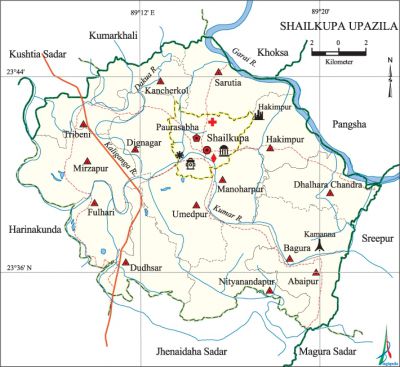
Shailkupa Upazila
Shailkupa Upazila (jhenaidah district) area 373.42 sq km, located in between 23°34' and 23°46' north latitudes and in between 89°07' and 89°23' east longitudes. It is bounded by khoksa and kumarkhali upazilas on the north, jhenaidah sadar and magura sadar upazilas on the south, pangsha and sreepur (magura) upazilas on the east, kushtia sadar and harinakunda upazilas on the west.
Population Total 331809; male 170861, female 160948; Muslim 292528, Hindu 39241, Buddhist 15 and others 25.
Water bodies Main rivers: gorai, kumar, Dakua, Kaliganga.
Administration Shailkupa Thana was formed in 1863 and it was turned into an upazila in 1983.
| Upazila | ||||||||
| Municipality | Union | Mouza | Village | Population | Density (per sq km) | Literacy rate (%) | ||
| Urban | Rural | Urban | Rural | |||||
|
1 |
14 |
168 |
265 |
31515 |
300294 |
889 |
47.2 |
43.4 |
| Municipality | ||||||||
|
Area (sq km) |
Ward |
Mahalla |
Population |
Density (per sq km) |
Literacy rate (%) | |||
|
20.93 |
9 |
24 |
31515 |
1506 |
47.3 | |||
| Union | ||||
| Name of union and GO code | Area (acre) | Population | Literacy rate (%) | |
| Male | Female | |||
|
Abaipur 10 |
5446 |
9269 |
9077 |
47.49 |
|
Umedpur 94 |
8002 |
13687 |
12556 |
49.07 |
|
Kancherkol 56 |
5295 |
10909 |
10362 |
41.09 |
|
Tribeni 88 |
4750 |
10229 |
9348 |
46.21 |
|
Dignagar 25 |
4936 |
9302 |
8867 |
42.87 |
|
Dudhsar 31 |
7069 |
12478 |
11510 |
41.96 |
|
Dhalhara Chandra 18 |
6478 |
12729 |
12131 |
44.64 |
|
Nityanandapur 69 |
8081 |
10895 |
10392 |
41.87 |
|
Fulhari 44 |
5195 |
10614 |
9678 |
42.66 |
|
Bagura 12 |
5938 |
9426 |
9028 |
46.16 |
|
Manoharpur 37 |
4976 |
7688 |
7284 |
47.45 |
|
Mirzapur 63 |
8617 |
14746 |
13679 |
39.70 |
|
Sarutia 75 |
6651 |
11801 |
11623 |
40.70 |
|
Hakimpur 50 |
5671 |
10655 |
10331 |
37.42 |
Source Bangladesh Population Census 2001, Bangladesh Bureau of Statistics.

Archaeological heritage and relics Shailkupa Shahi Mosque (1519-1531), Harihar Garh (Hakimpur),' Ram Gopal Mandir (built in Ballalsena period).
History of the War of Liberation In 1971 encounters between the freedom fighters and the Pak army were held on 5 April at Garaganj, 4 August at Alfapur and on 13 October at Abaipur. During the war of liberation the Pak army conducted indiscriminate killing and plundering; they also set many houses of these areas on fire. The freedom fighters raided the Shailkupa Police Station four times (8 April, 6 and 17 August and 11 November). On 26 November a battle was fought between the freedom fighters and the Pak army at the playground adjacent to the Kamanna Secondary School in which 27 freedom fighters were killed.
Marks of the War of Liberation Mass grave 1 (Kamanna); memorial monument 2 (Kabirpur).
Religious institutions Mosque 312, temple 161. Noted religious institutions: Shailkupa Shahi Mosque, Ram Gopal Mandir.
Literacy rate and educational institutions Average literacy 43.73%; male 47.7%, female 39.5%. Educational institutions: college 10, secondary school 49, primary school 156, satellite primary school 3, low cost primary school 11, madrasa 36. Noted educational institutions: Shailkupa Government Degree College 1993), Shailkupa Pilot High School (1893), Nagerhat Secondary School (1881), Benipur Multilateral Secondary School (1906), Falia S Secondary School (1922), Fulhari Secondary School (1929), Abaipur Ramsundar Secondary School (1889), Kancherkol Islamia Fazil Madrasa.
Cultural organisations Library 2, club 45, women's organisation 1, cinema hall 3.
Main sources of income Agriculture 65.01%, non-agricultural labourer 3.58%, industry 2.72%, commerce 15.13%, transport and communication 4%, service 4.37%, construction 0.75%, religious service 0.15%, rent and remittance 0.19% and others 4.10%.
Ownership of agricultural land Landowner 64.10%, landless 35.90%; agricultural landowner: urban 49.47% and rural 65.62%.
Main crops Paddy, wheat, betel leaf, jute, sugarcane, cotton, pulse, vegetables.
Extinct or nearly extinct crops China, linseed, sesame, arahar.
Main fruits Mango, jackfruit, banana, papaya, coconut.
Fisheries, dairies and poultries Fishery 6, dairy 41, poultry 48, nursery 54.
Communication facilities Pucca road 430 km, semi-pucca road 120 km, mud road 1120.
Extinct or nearly extinct traditional transport Palanquin, horse carriage, bullock cart.
Noted manufactories Rice mill, saw mill, ice factory, welding factory.
Cottage industries Goldsmith, blacksmith, weaving, potteries, wood work, embroidery, bamboo work and cane work.
Hats, bazars and fairs Hats and bazars are 30, fair 1, most noted of which are Shailkupa Bazar, Tribeni Hat, Dignagar Hat, Nityanandapur Hat, Fulhari Hat and Arong Mela of Ram Gopal.
Main exports Vegetables.
Access to electricity All the wards and unions of the upazila are under rural electrification net-work. However 20.52% of the dwelling households have access to electricity.
Sources of drinking water Tube-well 94.41%, tap 0.86%, pond 0.23% and others 4.50%.
Sanitation 23.68% (rural 23.12% and urban 29.06%) of dwelling households of the upazila use sanitary latrines and 46.75% (rural 46.98% and urban 44.59%) of dwelling households use non-sanitary latrines; 29.57% of households do not have latrine facilities.
Health centres Upazila health complex 1, family planning centre 14.
NGO activities Operationally important NGOs are brac, asa. [Md. Mohebbullah]
References Bangladesh Population Census 2001, Bangladesh Bureau of Statistics; Cultural survey report of Shailkupa Upazila 2007.
