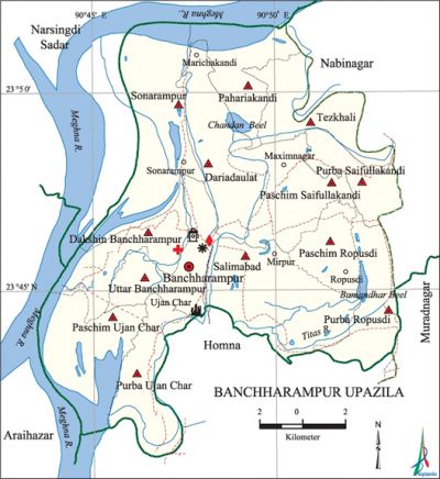
Banchharampur Upazila
Banchharampur Upazila (brahmanbaria district) area 217.38 sq km, located in between 23°41' and 23°53' north latitudes and in between 90°44' and 90°53' east longitudes. It is bounded by narsingdi sadar upazila on the north, homna upazila on the south, nabinagar and muradnagar upazilas on the east, Narsingdi Sadar and araihazar upazilas on the west.
Population Total 278240; male 138421, female 139819; Muslim 263490, Hindu 14738 and others 12.
Water bodies Main rivers: meghna, titas; Chandan and Bamandhar Beels are notable.
Administration Banchharampur Thana was formed in 1904 and it was turned into an upazila in 1983.
| Upazila | ||||||||
| Municipality | Union | Mouza | Village | Population | Density (per sq km) | Literacy rate (%) | ||
| Urban | Rural | Urban | Rural | |||||
|
1 |
13 |
76 |
118 |
15111 |
263129 |
1280 |
35.13 |
35.01 |
| Upazila Town | ||||||||
|
Area |
Mouza |
Population |
Density |
Literacy rate (%) | ||||
|
10.86 |
4 |
15111 |
1391 |
35.13 | ||||
| Union | ||||
| Name of union and GO code | Area (acre) | Population | Literacy rate (%) | |
| Male | Female | |||
|
Uttar Banchharampur 94 |
4404 |
12495 |
12907 |
33.43 |
|
Tezkhali 88 |
3337 |
10852 |
11423 |
34.10 |
|
Dakshin Banchharampur 14 |
3048 |
9763 |
9557 |
33.03 |
|
Dariadaulat 23 |
4997 |
11714 |
11984 |
35.59 |
|
Paschim Ujan Char 54 |
3252 |
10449 |
10169 |
34.74 |
|
Paschim Saifullakandi 36 |
3696 |
11625 |
11566 |
37.43 |
|
Paschim Ropusdi 45 |
2297 |
9682 |
9954 |
36.43 |
|
Pahariakandi 30 |
2663 |
6970 |
7084 |
31.22 |
|
Purba Ujan Char 77 |
3209 |
9789 |
9831 |
29.25 |
|
Purba Saifullakandi 59 |
1969 |
6723 |
7033 |
37.99 |
|
Purba Ropusdi 68 |
3296 |
10247 |
10196 |
42.56 |
|
Salimabad 81 |
6678 |
15931 |
16181 |
38.43 |
|
Sonarampur 83 |
5247 |
12181 |
11934 |
29.40 |
Source Bangladesh Population Census 2001, Bangladesh Bureau of Statistics.

Archaeological heritage and relics Khoshkandi Jami Mosque, Banchharampur Sadar Jami Mosque, Dhariar Char Jami Mosque, Ujan Char Kali Mandir, Ropusdi Dakshin Bazar Kali Mandir.'
History of the War of Liberation During the war of liberation, encounters were held between the freedom fighters and the Pak army on at Mirpur on 10 September, at Asadnagar on 15 and 18 September, at Zagrar Char on 27 November, at Durgarampur on 12 December and at village Dashdona on 13 December of the upazila. Besides, the Pak army conducted mass killing at village Ujan Char Krishnanagar on 5 August 1971. Five freedom fighters of the upazila were decorated with the title of Bir Pratik. Banchharampur upazila was liberated on 8 December 1971.
Religious institutions Mosque 532, temple 4, orphanage 4. Noted religious institutions: Khoshkandi Jami Mosque, Banchharampur Sadar Jami Mosque, Dhariar Char Jami Mosque, Ujan Char Kali Mandir, Ropusdi Dakshin Bazar Kali Mandir, Tomb of Shah Rahat Ali (Saifullah Kandhi), Tomb of Kandu Shah.'
Literacy rate and educational institutions Average literacy 35.0%; Male 38.4%, female 31.7%. Educational institutions: college 5, secondary school 19, primary school 119, madrasa 7. Noted educational institutions: Banchharampur Degree College (1973), Banchharampur Technical School and College (1980), Shah Rahat Ali College (1995), Dhariar Char High School (1947), Banchharampur SS Pilot High School (1948), Dariadaulat A Gani High School (1949), Banchharampur Girls Pilot High School (1970), Shah Rahat Ali High School (1973), Ropusdi Brindaban High School, Ujan Char KN High School, Banchharampur Ideal Technical Training Institute (2006), Radhanagar Kalikapur Rahmania Dakhil Madrasa (1993), Banchharampur Sobhania Islamia Dakhil Madrasa (1981).
Newspapers and periodicals Weekly: Titas (defunct).
Cultural organisations Library 5, club 8, cinema hall 2, playground 12.
Main sources of income Agriculture 44.44%, non-agricultural labourer 3.33%, industry 6.08%, commerce 13.53%, transport and communication 1.28%, service 6.81%, construction 1.15%, religious service' 0.31%, rent and remittance 5.58% and others 17.49%.
Ownership of agricultural land Landowner 59.86%, landless 40.14%; agricultural landowner: urban' 48.18% and rural 60.54%.
Main crops Paddy, jute, wheat, mustard, sesame, vegetables, pulse.
Extinct or nearly extinct crops Sugarcane, Kaun, china, tobacco.
Main fruits Mango, jackfruit, banana, black berry, litchi, papaya.
Fisheries, dairies and poultries 'This upazila has a number of fisheries, dairies and poultries.
Communication facilities Pucca road 147.875 km, mud road 108.658 km; waterways 38 nautical miles.
Extinct or nearly extinct traditional transport Palanquin, horse carriage, bullock cart.
Noted manufactories Rice mill, flourmill, ice factory, pen manufacturing industry.
Cottage industries Weaving, blacksmith, potteries, bamboo and cane work.
Hats, bazars and fairs Hats and bazars are 32, fairs 5, most noted of which are Banchharampur, Ropushdi, Marichakandi and Ujan Char bazars and Ropusdi Mela, Baishakhi Mela of Ujan Char and Dariadaulat Mela.
Main exports Wheat, jute, sesame, lungi, gamchha, sari and cotton fabrics.
Access to electricity All the wards and unions of this upazila are under rural electrification net-work. However 30.26% of the dwelling households have access to electricity.
Sources of drinking water Tube-well 91.84%, pond 0.86%, tap 0.69% and others 6.61%.
Sanitation 37.68% (rural 37.17% and urban 46.44%) of dwelling households of the upazila use sanitary latrines and 46.51% (urban 47.63% and rural 27.26%) of dwelling households use non-sanitary latrines; 15.81% of households do not have latrine facilities.
Heath centres Upazila health complex 1, hospital 1, rural health centre 2, family welfare centre 8, veterinary hospital 1, clinic 5.
Natural disasters Serious damages to settlements, fishery, livestock and crops were done by the floods of 1954, 1971, 1988, 1998, and 2004.
NGO activities Operatoinally important NGOs are Manab Kalyan Sangstha, Banchharampur Palli Unnayan Sangstha. [Md Abul Kasem Bhuiyan]
References Bangladesh Population Census 2001, Bangladesh Bureau of Statistics; Cultural survey report of Banchharampur Upazila 2007.
