Sylhet City Corporation
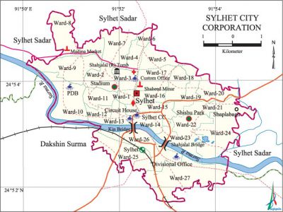
Sylhet City Corporation area 27.36 sq km, located in between 24°51´ and 24°55´ north latitudes and in between 91°50´ and 91°54´ east longitudes. It is bounded by sylhet sadarr upazila on the north, dakshin surma upazila on the south, Sylhet Sadar upazila on the east, Dakshin Surma and Sylhet Sadar upazilas on the west.
Population Total 270606; male 142320, female 128286.
Water bodies Main River: Surma.
Administration Sylhet Municipality was formed in 1867 and it was turned into City Corporation on April 9, 2001.
 |
 |
| City Corporation | ||||
| City Corporation | Thana | Word | Mahalla | |
| 1 | 4 | 27 | 218 | |
| Thana | ||||||||
| City Corporation Thana | Area (sq km) | Ward | Mahalla | Population | Density (per sq km) | Literacy rate (%) | ||
| Kotwali Model | 17.22 | 18 | 144 | 168271 | 9772 | 71.75 | ||
| Jalalabad (part) | 0.96 | 1 | 8 | 7409 | 6160 | 67.98 | ||
| Dakshin Surma (part) | 2.7 | 2 | 10 | 19912 | 7375 | 64.13 | ||
| Bimanbondar (part) | 1.84 | 2 | 22 | 22654 | 12312 | 71.38 | ||
| Shah Paran (part) | 4.64 | 4 | 42 | 52360 | 11284 | 66.70 | ||
Source Bangladesh Population Census 2001, Bangladesh Bureau of Statistics.
| Sylhet City Corporation at A Glance | ||||
| First Chairman | Ray Bahadur Dulal Chandra Deb | |||
| Municipality was formed | 1867 | |||
| Upgraded to City Corporation | 9 April 2001 | |||
| First Mayor | Badar Uddin Ahmed Kamran | |||
| Number of holding | 29381 | |||
| Wards | 27 | |||
| Ward commissioners | 27 | |||
| Reserved Seats for woman commissioners | 9 | |||
| Police Station | 2 | |||
| Roads | 21998 km | |||
| Park | 3 | |||
| Community Center | 30 | |||
| Gymnasium | 3 | |||
| Graveyard and Cemetery | 4 | |||
| Bus Terminals | 2 | |||
| Traffic Signal | 7 | |||
Source Bangladesh Population Census 2001, Bangladesh Bureau of Statistics; Field Reports.
[Tapan Palit]
References Bangladesh Population Census 2001, Bangladesh Bureau of Statistics; Cultural survey report of 2007; Field reports of Sylhet city corporation.
