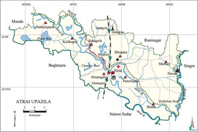
Atrai Upazila
Atrai Upazila (naogaon district) area 284.40 sq km, located in between 24°32' and 24°42' north latitudes and in between 88°49' and 89°06' east longitudes. It is bounded by raninagar and manda upazilas on the north, natore sadar upazila on the south, SINGRA upazila on the east, baghmara upazila on the west.
Population Total 193256; male 96129, female 97127; Muslim 175213, Hindu 17994, Buddhist 1, Christian 7 and others 41.
Water bodies Main rivers: atrai and Nagor; Pakar beel, Chander beel and Kaklaban beel are notable.
Administration Atrai Thana was formed in 1916 and it was turned into an upazila on 1 August1983.
| Upazila | ||||||||
| Municipality | Union | Mouza | Village | Population | Density (per sq km) | Literacy rate (%) | ||
| Urban | Rural | Urban | Rural | |||||
| - | 8 | 145 | 200 | 13202 | 180054 | 679 | 59.5 | 44.3 |
| Upazila Town | ||||||||
|
Area (sq km) |
Mouza |
Population |
Density |
Literacy rate (%) | ||||
| 6.55 | 6 | 13202 | 2016 | 59.5 | ||||
| Union | ||||||||
| Name of union and GO code | Area (acre) | Population | Literacy rate (%) | |||||
| Male | Female | |||||||
| Ahsanganj 10 | 12289 | 12212 | 12192 | 43.4 | ||||
| Kalikapur 52 | 7028 | 10605 | 11031 | 40.5 | ||||
| Panchupur 73 | 7109 | 14210 | 14301 | 50.0 | ||||
| Bisha 31 | 10542 | 12778 | 13122 | 47.1 | ||||
| Bhopara 21 | 8964 | 12377 | 12208 | 48.3 | ||||
| Maniari 63 | 12119 | 12226 | 12294 | 45.3 | ||||
| Sahagola 84 | 5773 | 11025 | 11010 | 43.6 | ||||
| Hatkalu Para 42 | 6458 | 10696 | 10969 | 42.9 | ||||
Source Bangladesh Population Census 2011, Bangladesh Bureau of Statistics.
Archaeological heritage and relics Mahadighi Mosque, Kazipara Mosque, Rabindranath's Kuthibari at Patisar, Tazia at Bankagram, Mirpur Mosque.
War of Liberation A battle between freedom fighters and the Pakistan army was fought in village Bandaikhara on 19 September 1971. The Pak army plundered and set many houses on fire of the village and killed many villagers indiscriminately. The enemy forces were challenged by the freedom fighters at a point near Taranagar, Gaoillah. Nine boats carrying Pak troops were sunk in a surprise attack. During the War of Liberation the Pak army along with their collaborators killed many freedom fighters of the upazila. Mass graves have been discovered at 2 places (near Sahagola Railway Station and on the Bandaikhara riverbank).
For details: see আত্রাই উপজেলা, বাংলাদেশ মুক্তিযুদ্ধ জ্ঞানকোষ (Encyclopedia of Bangladesh War of Liberation), বাংলাদেশ এশিয়াটিক সোসাইটি, ঢাকা ২০২০, খণ্ড ১।

Literacy rate and educational institutions Average literacy 45.4%; male 49.9%, female 41.0%. Noted educational institutions: Mollah Azad Memorial College (1968), Bhabanipur High School (1910), Kaligram Rabindranath Institute (1937), Ahsanullah Memorial High School (1941), Bandaikhara School (1874).
Newspapers and Periodicals Ahatasur and Atrai.
Cultural organizations Library 1, club 106, cinema hall 2, theatre group 3, playground 63, jatra dal 2.
Tourist spots Rabindranath's Kuthibari at Patisar.
Main sources of income Agriculture 73.20%, non-agircultural labourer 2.33%, commerce 11.13%, transport and communication 1.96%, service 3.42%, construction 0.79%, religious service 0.15%, rent and remittance 0.49% and others 6.53%.
Main crops Paddy, wheat, mustard.
Extinct or nearly extinct crops Linseed, sesame, aush paddy, indigo.
Main fruits Palm, jack-fruit, litchi, banana and papaya.
Fisheries, dairies and poultries This Upazila has a number of fisheries, dairies and poultries.
Communication facilities Roads: pucca 83 km, semi-pucca 15 km, mud road 208 km; waterway 10 km; railway 12 km.
Extinct or nearly extinct traditional transport palanquin, horse carriage and bullock cart.
Manufactories Flour mill, ice cream factory.
Cottage industries Goldsmith, blacksmith, weaving, potteries, bamboo works, woodworks, nakshi kantha.
Hats, bazars and fairs Hats and bazars are 12, fair 1 of which Ahsanganj hat and Shahebganj bazar are notable.
''Main exports Paddy, wheat, mustard, mat.
Access to electricity All the unions of this Upazila are under electricity net-work; however, 42.4% of the dwelling households have access to electricity.
Sources of drinking water Tube-well 96.2%, tap 0.8% and others 3.0%.
Sanitation 63.8% of dwelling households of the upazila use sanitary latrines and 27.1% of dwelling houses use non-sanitary latrines; 9.1% of households do not have latrine facilities.
Health centres Upazila health complex 1, clinic 2, community clinic 10.
Natuural disaster The follod of 1998 dismantled the dam of the area causing serious damage to crops and settlements.Serious damage to properties were held as a result of dismandle of the dam.
NGO activities asa, brac, proshika, caritas, Ujjiban. [Md. Muklesur Rahman]
References Bangladesh Population Census 2001 and 2011, Bangladesh Bureau of Statistics; Cultural survey report of Atrai Upazila 2007.
