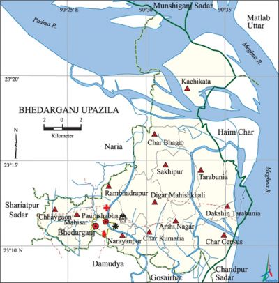
Bhedarganj Upazila
Bhedarganj Upazila (shariatpur district) area 261.90 sq km, located in between 23°08' and 23°24' north latitudes and in between 90°23' and 90°36' east longitudes. It is bounded by munshiganj sadar, naria and matlab uttar upazilas on the north, damudya and gosairhat upazilas on the south, chandpur sadar upazila and Meghna river on the east, Naria and shariatpur sadar upazilas on the west.
Population Total 253234; male 121494, female 131740; Muslim 246550, Hindu 6652, Christian 19 and others 13.
Water bodies Main rivers: padma and meghna; Banglabazar canal is notable.'
Administration Bhedarganj Thana was turned into an upazila in 1983 and Bhedarganj Municipality was formed in 1997.'
| Upazila | ||||||||
| Municipality | Union | Mouza | Village | Population | Density (per sq km) | Literacy rate (%) | ||
| Urban | Rural | Urban | Rural | |||||
| 1 | 13 | 88 | 372 | 9193 | 244041 | 967 | 68.5 (2001) | 41.9 |
| Municipality | ||||||||
|
Area |
Ward |
Mahalla |
Population |
Density |
Literacy rate (%) | |||
| 2.15 (2001) | 9 | 12 | 8169 | 3209 (2001) | 62.7 | |||
| Upazila Town | ||||||||
|
Area |
Mouza |
Population |
Density |
Literacy rate (%) | ||||
| 0.60 | 1 | 1024 | 1537 (2001) | 59.6 | ||||
| Union | ||||
| Name of union and GO code | Area (acre) | Population | Literacy rate (%) | |
| Male | Female | |||
| Arshi Nagar 12 | 3632 | 7895 | 8931 | 35.8 |
| Kachikata 51 | 14476 | 13294 | 12380 | 34.5 |
| Char Kumaria 17 | 4300 | 8178 | 9069 | 36.5 |
| Char Census 28 | 3839 | 9025 | 9107 | 28.6 |
| Char Bhaga 15 | 4152 | 12253 | 12225 | 39.8 |
| Chhaygaon 25 | 3878 | 6745 | 7770 | 54.7 |
| Tarabunia 94 | 6968 | 10504 | 11541 | 29.9 |
| Dhakhin Tarabunia 32 | 3464 | 8127 | 8816 | 24.2 |
| Digar Mahishkhali 43 | 5768 | 9748 | 11264 | 52.2 |
| Narayanpur 69 | 1521 | 3586 | 4228 | 53.0 |
| Mahisar 60 | 2874 | 7422 | 8655 | 56.2 |
| Rambhadrapur 77 | 3623 | 8718 | 9994 | 55.4 |
| Sakhipur 86 | 5682 | 11978 | 13612 | 50.7 |
Source Bangladesh Population Census 2011, Bangladesh Bureau of Statistics.

Archaeological heritage and relics Ashram of Digambari Ma at Mahisar.
War of Liberation During the war of liberation in 1971 the Pak army, in collaboration with their local agents, conducted mass killing and plundering in the upazila. Many freedom fighters were killed in two skirmishes and one direct battle with the Pak army. There is a mass grave at Mahisar of the upazila; a memorial monument has been established at Bhedarganj Sadar.
For details: see ভেদরগঞ্জ উপজেলা, বাংলাদেশ মুক্তিযুদ্ধ জ্ঞানকোষ (Encyclopedia of Bangladesh War of Liberation), বাংলাদেশ এশিয়াটিক সোসাইটি, ঢাকা ২০২০, খণ্ড ৭।
Religious institutions Mosque 450, temple 15, ashrama 1. Noted religious institutions: Kartikpur Zarina Trust Jami Mosque, Upazila Jami Mosque.
Literacy rate and educational institutions Average literacy 42.7%; male 42.7%, female 42.7%. Educational institutions: college 4, primary training institute 1, secondary school 25, primary school 106, community school 23, kindergarten 15, madrasa 9. Noted educational institutions: MA Degree College, Haji Shariatullah Degree College, Bhedarganj Head Quarter Pilot High School.
Cultural organisations Club 10, library 2, community centre 2, musical academy 1, Shilpakala Academy 1, cinema hall 1, auditorium 1, theatre group 1, playground 10.
Main sources of income Agriculture 67.98%, non-agricultural labourer 2.24%, industry 0.59%, commerce 11.64%, transport and communication 1.89%, service 5.61%, construction 1.04%, religious service 0.24%, rent and remittance 1.57% and others 7.20%.
Ownership of agricultural land Landowner 66.83%, landless 33.17%; agricultural landowner: urban 47.27% and rural 67.50%.
Main crops Paddy, jute, mustard, wheat, sugarcane, onion, vegetables.
Extinct or nearly extinct crops Sesame, linseed, barley.
Main fruits Mango, black berry, jackfruit, plum.
Fisheries, dairies and poultries Fishery 25, dairy 45, poultry 58.
Communication facilities Roads: pucca 187 km, semi-pucca road 227 km, mud road 280 km; waterways 74.77 km. culverts 9, bridges 8.
Extinct or nearly extinct traditional transport Palanquin.
Noted manufactories Rice mill, flour mill, ice factory, saw mill.
Cottage industries Blacksmith, potteries.
Hats, bazars and fairs Hats and bazars are 27, fair 1. Bhedarganj Bazar, Sener Bazar and Mahisar Mela are notable.
Main exports Jute.
Access to electricity All the wards and unions of the upazila are under rural electrification net-work. However 39.2% dwellings have access to electricity.
Sources of drinking water Tube-well 96.4%, tap 0.1% and others 3.5%. The presence of arsenic has been detected in the shallow tube well water of the upazila.
Sanitation 83.8% of dwelling households of the upazila use sanitary latrines and 13.3% of dwelling houses use non-sanitary latrines; 2.9% of households do not have latrine facilities.
Health centres Upazila health complex 1, union health and family planning centre 10, clinic 20, diagnostic centre 1, veterinary hospital 1.
NGO activities asa, brac, CARE. [Billal Hossain]
References Bangladesh Population Census 2001 and 2011, Bangladesh Bureau of Statistics; Cultural survey report of Bhedarganj Upazila 2007.
