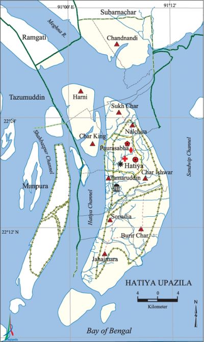
Hatiya Upazila
Hatiya Upazila (noakhali district) area 1507.35 sq km, located in between 22°07' and 22°35' north latitudes and in between 90°56' and 91°11' east longitudes. It is bounded by noakhali sadar and ramgati upazilas on the north, bay of bengal on the south and the east, manpura upazila on the west.
Population Total 452463; male 223853, female 228610; Muslim 424655, Hindu 27729, Buddhist 23, Christian 21 and others 35.
Water bodies Main river: meghna; Shahbazpur and Hatiya Channels are notable.
Administration Hatiya Thana was turned into an upazila in 1983.
| Upazila | ||||||||
| Municipality | Union | Mouza | Village | Population | Density (per sq km) | Literacy rate (%) | ||
| Urban | Rural | Urban | Rural | |||||
| 1 | 11 | 44 | 62 | 86514 | 365949 | 300 | 24.99 (2001) | 32.0 |
| Municipality | ||||||||
| Area (sq km) |
Ward | Mahalla | Population | Density (per sq km) |
Literacy rate (%) | |||
| - | 9 | 23 | 44802 | - | 57.2 | |||
| Upazila Town | ||||||||
|
Area |
Mouza |
Population |
Density |
Literacy rate (%) | ||||
| - | 2 | 41712 | - | 27.5 | ||||
| Union | ||||
| Name of union and GO code | Area (acre) | Population | Literacy rate (%) | |
| Male | Female | |||
| Char Ishwar 28 | 20784 | 12992 | 13236 | 37.6 |
| Char King 38 | 25456 | 19601 | 20471 | 40.4 |
| Chandnandi 19 | 38386 | 40443 | 40066 | 16.6 |
| Jahajmara 57 | 52690 | 27772 | 28233 | 34.3 |
| Tamaruddin 95 | 20954 | 13974 | 14005 | 43.4 |
| Nalchira 66 | 27176 | 6457 | 6106 | 47.8 |
| Nijum Dip 69 | 40141 | 6518 | 6278 | 14.1 |
| Burir Char 9 | 40645 | 26330 | 27413 | 34.6 |
| Sukh Char 85 | 25365 | 5220 | 5349 | 30.4 |
| Sonadia 76 | 22367 | 16567 | 17616 | 41.6 |
| Harni 47 | 49961 | 26387 | 26627 | 25.2 |
Source Bangladesh Population Census 2001 and 2011, Bangladesh Bureau of Statistics.

War of Liberation On 11 May 1971 the Pak army raided the Hatiya Town and conducted heavy tortures and plundering; they also set many houses on fire. The Pak army shot six persons dead at Afazia Bazar and two persons at Uskhali Bazar. Freedom fighters attacked the Hatiya Police Station of 14 August and 120 razakars and hostile police surrendered to the freedom fighters.
For details: see হাতিয়া উপজেলা, বাংলাদেশ মুক্তিযুদ্ধ জ্ঞানকোষ (Encyclopedia of Bangladesh War of Liberation), বাংলাদেশ এশিয়াটিক সোসাইটি, ঢাকা ২০২০, খণ্ড ১০।
Religious institutions Mosque 410, temple 14. Noted religious institutions: Afazia Bazar Mosque, Tamaruddin Bazar Mosque, Kali Mandir at Uchhkhali Bazar.
Literacy rate and educational institutions Average literacy 34.2%; male 35.6%, female 32.9%. Educational institutions: college 4, secondary school 28, primary school 216, maktab 36, madrasa 154. Noted educational institutions: Hatiya Degree College (1969), Hatiya Dwip Govt. College (1970), Hatiya' Union Model Pilot High School (1912), Tamaruddin Ahamadia Fazil Madrasa (1922), Hatiya Rahmania Fazil Madrasa (1912).
Newspapers and periodicals Weekly: Hatiyar katha;' Fortnightly: Hatiya Kantha.
Cultural organisations Library 3, club 29, playground 22, cinema hall 1.
Amusement centers Nijhum Dwip (island) is one of the most important tourist spots of the country. Sun rise and sun set can be viewed from the vast extended sea beaches located on the southern and western extremities of the island. Considering the natural beauty and to preserve the bio-diversity of the island the government of Bangladesh declared 40 thousand acres of land of the upazila as national park in 2001. Besides, the island renders considerable contributions to Bangladesh economy, especially in the sectors of fishery, and of collecting honey.
Main sources of income Agriculture 65.38%, non-agricultural labourer 5.27%, industry 0.48%, commerce 11.96%, transport and communication 1.33%, service 4.19%, construction 1%, religious service 0.39%, rent and remittance 0.72% and others 9.28%.
Ownership of agricultural land Landowner 45.03%, landless 54.97%; agricultural landowner: urban 14.62% and rural 49.62%.
Main crops Paddy, jute, potato, sugarcane, pulse, oil seed, betel leaf.
Extinct or nearly extinct crops Mustard, aush paddy.
Main fruits Jackfruit, mango, banana, papaya, betel nut, coconut, date.
Fisheries, dairies and poultries Poultry 12, hatchery 17.
Communication facilities Pucca road 129.85 km, semi-pucca road 59.60 km, mud road 687.19 km; waterway 205.92 km.
Extinct or nearly extinct traditional transport Palanquin, horse carriage, bullock cart.
Noted manufactories Rice mill, flour mill, ice factory, chilli mill, welding factory.
Cottage industries Jute work, weaving, blacksmith, potteries, crafts, embroidery, cane work, bamboo work, wood work, brass work.
Hats, bazars and fairs Hats and bazars are 40, fairs 2, most noted of which are Uchhkhali, Afazia, Tamruddin, Chaumuhani, Sagaria, Jahajmara and Nalchida' Bazars; Khaser Hat, Baishakhi Mela at Uchhkhali bazar.
Main exports Betel nut, coconut, betel leaf.
Access to electricity All the unions of the upazila are under rural electrification net-work. However 8.9% of the dwelling households have access to electricity.
Natural resources Natural gas has been discovered in Char King union of the upazila.
Sources of drinking water Tube-well 89.6%, tap 0.2% and others 10.2%.
Sanitation 53.2% of dwelling households of the upazila use sanitary latrines and 38.6% of dwelling households use non-sanitary latrines; 8.2% of households do not have latrine facilities.
Health centres Upazila health centre 1, family planning centre 10, satellite clinic 6.
Natural disasters The devastating cyclone and tidal bore on 12 November 1970 caused death of more than one lakh people of the coastal area. It also caused heavy damages to settlements, livestock and crops of the region.
NGO activities Operationally important NGOs are 'asa, proshika, CARE, caritas. [Md Tawhid Hussain Chowdhury]
References Bangladesh Population Census 2001 and 2011, Bangladesh Bureau of Statistics; Cultural survey report of Hatiya Upazila 2007.
