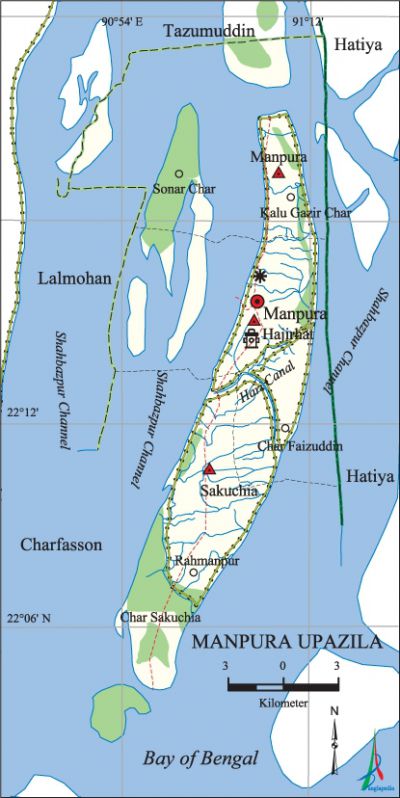
Manpura Upazila
Manpura Upazila (bhola district) area 373.18 sq km, located in between 22°06' and 22°26' north latitudes and in between 90°52' and 91°01' east longitudes. It is bounded by tazumuddin upazila on the north, bay of bengal on the south, hatiya upazila on the east, lalmohan and char fasson upazilas on the west.
Population Total 76582; male 38746, female 37836; Muslim 71985, Hindu 4594 and Christian 3.
Water bodies Main river: meghna; Shahbazpur Channel and Hari Canal are notable.
Administration Manpura Thana was formed on 25 December 1970 and it was turned into an upazila on 7 November 1983.
| Upazila | ||||||||
| Municipality | Union | Mouza | Village | Population | Density (per sq km) | Literacy rate (%) | ||
| Urban | Rural | Urban | Rural | |||||
| - | 4 | 18 | 30 | 1023 | 75559 | 205 | 55.9 | 31.8 |
| Upazila Town | ||||||||
|
Area (sq km) |
Mouza |
Population |
Density (per sq km) |
Literacy rate (%) | ||||
| 3.95 | 1 | 1023 | 259 | 55.9 | ||||
| Union | ||||
| Name of union and GO code | Area (acre) | Population | Literacy rate (%) | |
| Male | Female | |||
| Manpura 47 | 28154 | 9309 | 8958 | 27.7 |
| Uttar Sakuchia 71 | 19385 | 8636 | 8594 | 30.0 |
| Dakshin Sakuchia 21 | 20218 | 7759 | 7836 | 29.5 |
| Hajirhat 23 | 24420 | 13042 | 12448 | 38.1 |
Source Bangladesh Population Census 2011, Bangladesh Bureau of Statistics.

War of Liberation There was no direct encounter between the freedom fighters and the Pak army in the upazila but the local freedom fighters joined hands with freedom fighters to fight against Pak army in other areas of Bhola district.
For details: see মনপুরা উপজেলা, বাংলাদেশ মুক্তিযুদ্ধ জ্ঞানকোষ (Encyclopedia of Bangladesh War of Liberation), বাংলাদেশ এশিয়াটিক সোসাইটি, ঢাকা ২০২০, খণ্ড ৭।
Religious institutions Mosque 110, temple 13.
Literacy rate and educational institutions Average literacy 32.1%; male 31.9%, female 32.2%. Educational institutions: college 2, secondary school 8, primary school 39, madrasa 35. Noted educational institutions: Manpura Degree College (1996), Manoara Begum Mohila College (2003), Manpura Secondary School, Hajirhat Secondary School, Sakuchia Secondary School.
Newspapers and periodicals Manpura Bani.
Cultural organisations Club 35, cinema hall 1, playground 9, shilpakala academy 1.
Main sources of income Agriculture 72.50%, non-agricultural labourer 4.30%, industry 0.19%, commerce 9.68%, transport and communication 0.86%, service 3.32%, construction 0.48%, religious service 0.32%, rent and remittance 0.03% and others 8.32%.
Ownership of agricultural land Landowner 47.21%, landless 52.79%; agricultural landowner: urban 57.95% and rural 46.84%.
Main crops Paddy, wheat, pulse, chilli, sweet potato, nut, potato, vegetables.
Main fruits Mango, jackfruit, papaya, banana, grape, water-melon.
Fisheries, dairies and poultries This upazila has a number of fisheries, dairies and poultries.
Communication facilities Pucca road 63 km, mud road 75 km; waterway 120. Bridge 14; culvert 90; Halipad 1.
Extinct or nearly extinct traditional transport Palanquin, bullock cart.
Cottage industries Goldsmith, potteries, blacksmith, bamboo and wood work.
Hats, bazars and fairs Hats and bazars are 11, fairs 2, most noted of which are Master Hat, Hazirhat, Ram Nawaz Bazar, Bangla Bazar, Sakuchia Bazar and Chaitra Samkranti Mela.
Main exports Paddy, chilli, pulse, nut, Hilsa.
Access to electricity All the unions of the upazila are under electrification net-work. However 14.1% of the dwelling households have access to electricity.
Sources of drinking water Tube-well 96.1% and others 3.9%.
Sanitation 26.7% of dwelling households of the upazila use sanitary latrines and 55.2% of dwelling households use non-sanitary latrines; 18.1% of households do not have latrine facilities.
Health centres Upazila health complex 1, satellite clinic 1.
Natural disasters Many people were victims of the cyclone and tidal bore on 12 November 1970.
NGO activities Operationally important NGOs are caritas, brac, Swanirvar Bangladesh. [Zakir Hussain]
References Bangladesh Population Census 2001 and 2011, Bangladesh Bureau of Statistics; Cultural survey report of Manpura Upazila 2007.
