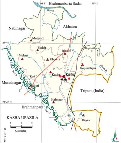
Kasba Upazila
Kasba Upazila (brahmanbaria district) area 209.77 sq km, located in between 23°39' and 23°52' north latitudes and in between 91°02' and 91°14' east longitudes. It is bounded by akhaura and brahmanbaria sadar upazilas on the north, brahmanpara upazila on the south, Akhaura and tripura state of India on the east, nabinagar and muradnagar upazilas on the west.
Population Total 319221; male 151852, female 167369; Muslim 305419, Hindu 13756, Christian 12, Buddhist 1 and others 33.
Water bodies Main rivers: Haura, titas and Buri.
Administration Kasba Thana was formed in 1908 and it was turned into an upazila on 14 September 1983.
| Upazila | ||||||||
| Municipality | Union | Mouza | Village | Population | Density (per sq km) | Literacy rate (%) | ||
| Urban | Rural | Urban | Rural | |||||
| 1 | 10 | 138 | 209 | 40416 | 278805 | 1522 | 56.0 | 49.9 |
| Municipality | ||||||||
|
Area (sq km) |
Ward |
Mahalla |
Population |
Density (per sq km) |
Literacy rate (%) | |||
| 16.86 | 9 | 34 | 40416 | 2397 | 56.0 | |||
| Union | ||||
| Name of union and GO code | Area (acre) | Population | Literacy rate (%) | |
| Male | Female | |||
| Kasba Paschim 63 | 1335 | 4763 | 5279 | 48.6 |
| Kaimpur 56 | 4827 | 15670 | 17449 | 49.4 |
| Kuti 69 | 5022 | 19152 | 20499 | 51.0 |
| Kherera 65 | 3293 | 9693 | 10844 | 59.1 |
| Gopinathpur 50 | 7609 | 17188 | 18479 | 51.7 |
| Badair 18 | 3018 | 8289 | 9723 | 49.9 |
| Bayek 31 | 6282 | 14442 | 15532 | 48.0 |
| Binauti 37 | 5926 | 16098 | 17427 | 49.0 |
| Mulgram 94 | 5205 | 14629 | 17314 | 46.4 |
| Mehari 82 | 5450 | 12179 | 14156 | 47.4 |
Source Bangladesh Population Census 2011, Bangladesh Bureau of Statistics.
Archaeological heritage and relics Kuti Bara Masjid and Moinpur Mosque (eighteenth century), three domed Mosque at Araibari, Kalibari Mandir (Kheora, seventeenth century).
War of Liberation Kasba Upazila was the biggest battlefield of sector 2 of the war of liberation. Freedom fighters had encounters with the Pak army at Latoamura and Chandrapur on 22 November 1971 and more than one hundred freedom fighters were killed in these encounters. In another encounter at Kullahpathar about 49 freedom fighters were killed. Besides, encounters between the freedom fighters and the Pak army were held at Araibari, Akchhina, Horiabaha, Khirnal, Chatgachh and Bayek areas. There are 8 tombs of martyr freedom fighters at Lakshmipur, Kullapathar, Simrail and Jamsherpur.
For details: see কসবা উপজেলা, বাংলাদেশ মুক্তিযুদ্ধ জ্ঞানকোষ (Encyclopedia of Bangladesh War of Liberation), বাংলাদেশ এশিয়াটিক সোসাইটি, ঢাকা ২০২০, খণ্ড ২।

Religious institutions Mosque 372, temple 6, sacred place 1. Noted religious institutions: Kuti Bara Mosque, Mainpur Mosque, three domed Mosque at Araibari, Kalibari Mandir, mazars of Shah Sufi Abu Saiyed Asgar Ahmad Al Quadwri (R), Shah Sufi Maulana Mohammad Habibur Rahman (R) and Abdus Sattar Mashreki.
Literacy rate and educational institutions Average literacy 50.7%; male 50.5%, female 50.8%. Educational institutions: college 8, secondary school 42, primary school 153, madrasa 30. Noted educational institutions: Kasba Government High School (1899), Kuti Atal Bihari High School (1918), Jamsherpur High School (1923), Kheora Anandamayee High School (1975).
Newspapers and periodicals Weekly: Agnibani; fortnightly: Sakaler Surya.
Cultural organisations Library 2, club 15, press club 2, theatre group 2, cinema hall 2, playground 22, auditorium 1.
Main sources of income Agriculture 52.08%, non-agricultural labourer 2.27%, commerce 15.06%, transport and communication 3.20%, service 10.06%, construction 1.51%, rent and remittance 6.40% and others 9.42%.
Ownership of agricultural land Landowner 60.99%, landless 39.01%; agricultural landowner: urban 45.30% and rural 61.92%.
Main crops Paddy, jute, wheat, potato, maize.
Extinct or nearly extinct crops Pulse, varieties of oil seeds.
Main fruits Mango, blackberry, jackfruit, litchi, banana, coconut, papaya, plum.
Fisheries, dairies and poultries Fishery 1, dairy 27, poultry 56, hatchery 18, artificial breeding centre 4.
Communication facilities Pucca road 214.76 km, semi-pucca road 36.19 km, mud road 255.5 km; Railine 18 km.
Extinct or nearly extinct traditional transport Palanquin, bullock cart.
Noted manufactories Flour mill, ice factory, rice mill, oil mill, printing press, biscuit factory, brick-field,' fish food processing factory, welding factory.
Cottage industries Goldsmith, blacksmith, potteries, bamboo and cane work.
Hats, bazars and fairs Hats and bazars are 38, fairs 5, most noted of which are Kuti Bazar, Kasba Bazar, Muslimganj Bazar, Chargachh Bazar, Gopinathpur Bazar, Chaumuhani Mela, Mankasair Mela and Mehari Mela.
Main exports Paddy, jute.
Access to electricity All the wards and unions of the upazila are under rural electrification net-work. However 74.3% of the dwelling households have access to electricity.
Mineral resources The 19th natural gas field (Salda Gas Field) is located in Kasba. The total gas reserve is about 200 million cubic feet; it has two wells.
Sources of drinking water Tube-well 96.1%, tap 1.1% and others 2.8%.
Sanitation 76.7% of dwelling households of the upazila use sanitary latrines and 21.3% of dwelling households use non-sanitary latrines; 2.0% of households do not have latrine facilities.
Health centres Upazila health complex 1, satellite clinic 4, health and family welfare centre 4.
Natural disasters The floods of 1988, 1998 and 2004 caused heavy damages to settlements and other properties of the upazila.
NGO activities Operationally important NGOs are brac, asa, Save the Children. [Md Abu Russel Chowdhury]
References Bangladesh Population Census 2001 and 2011, Bangladesh Bureau of Statistics; Cultural survey report of Kasba Upazila 2007.
