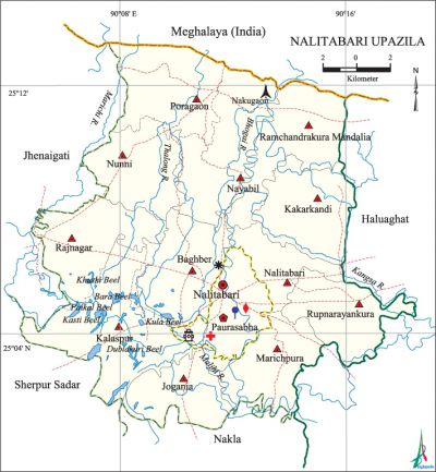
Nalitabari Upazila
Nalitabari Upazila (sherpur district) area 327.60 sq km, located in between 25°01' and 25°13' north latitudes and in between 90°04' and 90°19' east longitudes. It is bounded by Meghalaya state of India on the north, sherpur sadar and nakla upazilas on the south, haluaghat upazila on the east, jhenaigati upazila on the west.
Population Total 251361; male 124649, female 126712; Muslim 237930, Hindu 9508, Buddhist 5, Christian 3679 and others 239. Indigenous communities such as garo, hajong, Hodi, Mandai and Koch belong to this upazila.
Water bodies Main rivers: Bhogai, kangsa, Maljhi, Thalong; Khuski, Paikal, Kasti, Bara, Kula and Dublakuri beels are notable.
Administration Nalitabari Thana was turned into an upazila in 1983.
| Upazila | ||||||||
| Municipality | Union | Mouza | Village | Population | Density (per sq km) | Literacy rate (%) | ||
| Urban | Rural | Urban | Rural | |||||
| 1 | 12 | 107 | 140 | 27142 | 224219 | 767 | 55.0 | 37.0 |
| Municipality | ||||||||
|
Area (sq km) |
Ward |
Mahalla |
Population |
Density (per sq km) |
Literacy rate (%) | |||
| 9.25 | 9 | 17 | 27142 | 2934 | 55.0 | |||
| Union | ||||
| Name of union and GO code | Area (acre) (Census 2001) | Population | Literacy rate (%) | |
| Male | Female | |||
| Kalaspur 41 | 9580 | 14025 | 13821 | 32.2 |
| Kakarkandi 38 | 6422 | 7836 | 8149 | 41.5 |
| Nunni 69 | 12959 | 8948 | 9188 | 40.2 |
| Nayabil 55 | 7699 | 8178 | 8414 | 42.1 |
| Nalitabari 51 | 12079 | 7073 | 7178 | 38.1 |
| Poragaon 75 | 7005 | 7556 | 7898 | 39.4 |
| Baghber 30 | 16301 | 9987 | 9964 | 38.8 |
| Marichpura 72 | 5599 | 9223 | 9383 | 38.5 |
| Jogania 34 | 7380 | 10651 | 10625 | 32.0 |
| Rupnarayankura 94 | 11934 | 7322 | 7644 | 32.2 |
| Rajnagar 77 | 6134 | 12145 | 12721 | 36.1 |
| Ramchandrakura Mandalia 86 | 14167 | 8053 | 8237 | 36.7 |
Source Bangladesh Population Census 2001 and 2011, Bangladesh Bureau of Statistics.

Archaeological heritage and relics Kamla Rani or Sutanali Dighi (Nalitabari).
Historical events A great peasant assemblage of the eastern region of the undivided India was held in this upazila in 1937.
War of Liberation In 1971 many freedom fighters including Commander Nazmul Ahsan were killed in an encounter with Pakistan army at Chellakhali Khal (canal). The Pak army killed 185 innocent people at village Sohagpur of this upazila on 27 July 1971. There is a mass grave at Nakugaon; a martyr memorial monument has been built.
For details: see নলিতাবাড়ী উপজেলা, বাংলাদেশ মুক্তিযুদ্ধ জ্ঞানকোষ (Encyclopedia of Bangladesh War of Liberation), বাংলাদেশ এশিয়াটিক সোসাইটি, ঢাকা ২০২০, খণ্ড ৫।
Religious institutions Mosque 364, temple 20, church 19, tomb 10.
Literacy rate and educational institutions Average literacy 39.0%; male 40.5%, female 37.5%. Educational institutions: college 4, technical college 1, secondary school 33, primary school 96, madrasa 52. Noted educational institutions: Nazmul Smriti College (1972), Nalitabari Shahid Abdur Rashid Mohila College (1996), Hiranmayee High School (1919), Taraganj Pilot High School (1927), Taraganj Pilot Girl's High School (1959), Taraganj Fazil Madrasa (1950), Garkanda Mohila Alim Madrasa (1994).
Cultural organisations Library 1, club 20, theatre group 2, cinema hall 2, social organisation 10, playground 20.
Important installations and Tourist spots Madhutila Ecopark, Rubber Dam on the bank of Bhogai river.
Main sources of income Agriculture 70.06%, non-agricultural labourer 6.25%, industry 0.57%, commerce 8.59%, transport and communication 2.15%, service 2.93%, construction 0.64%, religious service 0.17%, rent and remittance 0.13% and others 8.51%.
Ownership of agricultural land Landowner 55.02%, landless 44.98%; agricultural landowner: urban 42.45% and rural 56.51%.
Main crops Paddy, jute, wheat, potato, mustard, vegetables.
Extinct or nearly extinct crops Jute, sweet potato, kaun, linseed, arahar.
Main fruits Mango, jackfruit, litchi, banana.
Fisheries, dairies and poultries Fishery 5, dairy 21, poultry 15, hatchery 2, nursery 4.
Communication facilities Pucca road 128 km, semi-pucca road 29 km, mud road 508 km.
Extinct or nearly extinct traditional transport Palanquin, bullock cart.
Noted manufactories Rice mill 70, ice factory 2, welding factory 20.
Cottage industries Goldsmith, blacksmith, potteries, weaving, bamboo and cane work, wood work, tailoring.
Hats, bazars and fairs Hats and bazars are 41, most noted of which are Nalitabari Bazar, Araiani Bazar, Naiani Ghatpara Bazar, Koter Bazar and Barmari Bazar.
Main exports Rice, banana, vegetables.
Access to electricity All the wards and unions of the upazila are under rural electrification net-work. However 34.9% of the dwelling households have access to electricity.
Natural resources White soil, pebble, bolder, white sand.
Sources of drinking water Tube-well 91.4%, tap 0.8% and others 7.8%.
Sanitation 62.7% of dwelling households of the upazila use sanitary latrines and 30.8% of dwelling households use non-sanitary latrines; 6.5% of households do not have latrine facilities.
Health centres Upazila health complex 1, family planning centre 6, community clinic 13, satellite clinic 2.
Natural disasters Many people were victims of the famine of 1943.'
NGO activities brac, asa, CARE, caritas. [Joti Poddar]
References Bangladesh Population Census 2001 and 2011, Bangladesh Bureau of Statistics; Cultural survey report of Nalitabari Upazila 2007.
