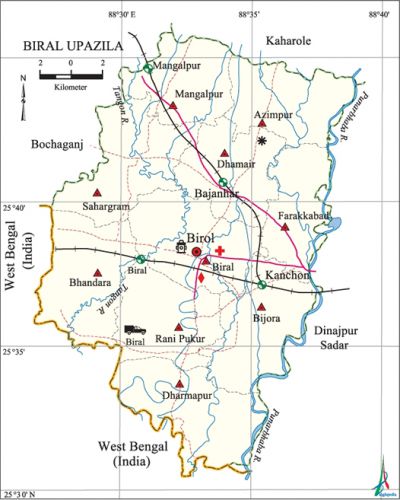
Biral Upazila
Biral Upazila (dinajpur district) area 353.98 sq km, located in between 25°31' and 25°46' north latitudes and in between 88°26' and 88°38' east longitudes. It is bounded by bochaganj and kaharole upazilas on the north, dinajpur sadar upazila and west bengal of India on the south, Dinajpur Sadar upazila and punarbhaba river on the east, Bochaganj 'upazila and West Bengal of India on the west.
Population Total 257925; male 130160, female 127765; Muslim 188909, Hindu 64453, Buddhist 77, Christian 932 and others 3554. Christian 31 and others 2846. Indigenous communities such as santal, oraon, munda, Malo, Mahali belong to this upazila.
Water bodies Punarbhaba and tangon rivers; Nal and Karai beels are notable.
Administration Biral Thana was formed in 1915 and it was turned into an' upazila in 1984.
| Upazila | ||||||||
| Municipality | Union | Mouza | Village | Population | Density (per sq km) | Literacy rate (%) | ||
| Urban | Rural | Urban | Rural | |||||
| - | 10 | 237 | 237 | 9059 | 248866 | 729 | 56.2 | 47.0 |
| Upazila Town | ||||||||
|
Area (sq km) |
Mouza |
Population |
Density (per sq km) |
Literacy rate (%) | ||||
| 6.11 | 3 | 9059 | 1483 | 56.2 | ||||
| Union | ||||||||
| Name of Union and GO Code | Area (sq km) | Population | Literacy rate (%) | |||||
| Male | Female | |||||||
| Azimpur 13 | 7791 | 9945 | 9944 | 43.3 | ||||
| Dharmapur 57 | 10432 | 12883 | 12378 | 36.8 | ||||
| Dhamair 47 | 8148 | 10415 | 10228 | 47.2 | ||||
| Farakkabad 66 | 6689 | 14959 | 14371 | 47.0 | ||||
| Bijora 38 | 4861 | 17788 | 17141 | 54.3 | ||||
| Biral 28 | 8575 | 17565 | 17171 | 48.7 | ||||
| Bhandara 19 | 9629 | 11420 | 11594 | 47.7 | ||||
| Mangalpur 76 | 7140 | 9712 | 9786 | 45.2 | ||||
| Rani Pukur 85 | 8532 | 12827 | 12448 | 49.9 | ||||
| Sahargram 95 | 9606 | 12646 | 12704 | 48.8 | ||||
Source Bangladesh Population Census 2011, Bangladesh Bureau of Statistics.

Archaeological heritage and relics Sen Dighi (tank), Mazar of Mulluk Dewan and dighi, Meherabia Jami Mosque.
Historical events santal rebellion was held in this upazila (1855-1856). On 13 November 1971 the Pak army killed 37 innocent persons at Bahala in Bijore union.
War of Liberation On 15 December 1971, 30 freedom fighters were killed in an encounter with the Pak army at Bagulakhari. Besides, about 100 Pak soldiers were killed in an encounter between the freedom fighters and the Pak army at Bahabal.There is a mass grave in the upazila and a War of Liberation Museum has been established.
For details: see বিরল উপজেলা, বাংলাদেশ মুক্তিযুদ্ধ জ্ঞানকোষ (Encyclopedia of Bangladesh War of Liberation), বাংলাদেশ এশিয়াটিক সোসাইটি, ঢাকা ২০২০, খণ্ড ৭।
Religious institutions Mosque 434, temple 82, tomb 4. Noted religious institutions: Meherabya Jami Mosque, Biral Jami Mosque, Munshi Para Jami Mosque, Mulluk Dewan Tomb, Sendighi Kali Mandir.
Literacy rate and educational institutions Average literacy 47.3%; male 50.7% female 43.9%. Educational institutions: college 8, secondary school 48, primary school 157, madrasa 17. Noted educational institutions: Biral Degree College (1972), Biral Girls' College (1994), Dhukurjhari College (1994), Moinul Hasan College (1948), Bijora High School (1940), Uttar Bishnapur VMSC High School (1945), Biral Pilot High School (1994), Munshi Para High School (1960), Karala Madhabati High School (1968), Biral Pilot Girls High School (1977), Kanaibari High School, Mohana-Mangalpur High School, Biral Govt. Primary School, Silver Jubilee MC School, Dewandighi Dakhil Madrasa, Mangalpur Senior Madrasa.
Newspapers and periodicals Biral Barta (Defunct).
Cultural organisations Club 17, library 1,' cinema hall 1, women's organisation 1, playground 8.
Tourist spots Karai Beel.
Main sources of income Agriculture 70.45%, non-agricultural labourer 3.16%, industry 1.03%, commerce 12.01%, transport and communication 2.86%, service 4.46%, construction 1.73%, religious service 0.17%, rent and remittance 0.13% and others 4%.
Ownership of agricultural land Landowner 50.61%, landless 49.39%; agricultural landowner: urban 54.07%' and rural 50.50%.
Main crops Paddy, wheat, corn, sugarcane, potato, sesame, onion, oil seed, vegetables.
Extinct or nearly extinct crops Aush paddy, tobacco, pulse.
Main fruits Mango, banana, jackfruit, litchi, black berry.
Communication facilities Roads: pucca road 177.31 km, semi pacca road 1.35 km, mud road 587.36 km; railways 36 km.
Extinct or nearly extinct traditional transport Palanquin, bullock cart, 'horse carriage.
Noted manufactories Rice mill, flour mill, saw mill, husking machine, ice factory, biscuit factory.
Cottage industries Goldsmith, potteries, blacksmith, woodworks, Bamboo work, cane work.
Hats, bazars and fairs Hats and bazars are 30, fairs 3; Bahbal Hat, Kashidanga Hat, Dhukurjhari Hat, Narabari Hat, Biral Hat, Kaliaganj Hat, Kamdevpur Hat, Chaker Hat, Board Hat; Dhukurjhari and Narabari fairs are notable.
Main exports Litchi, corn, rice, onion.
Access to electricity All the unions of the upazila are under rural electrification net-work; however, 30.9% dwelling households have access to electricity.
Sources of drinking water Tube-well 97.2%, tap 0.9% and others 1.9%.
Sanitation 36.5% of dwelling households of the upazila use sanitary latrines and 21.8% of dwelling houses use non-sanitary latrines; 41.7% of households do not have latrine facilities.
Health centres Upazila health complex 1, union health and family planning centre 10, community health centre 13 and Islamic Mission Hospital 1.
Natural disasters Heavy damages to settlements, livestock and crops of the upazila were caused due to floods of 1968 and 1988.
NGO activities brac, asa, caritas, proshika, CDA, Shiksha Foundation. [Md. Mizanur Rahman]
References Bangladesh Population Census 2001 and 2011, Bangladesh Bureau of Statistics; Cultural survey report of Biral Upazila 2007.
