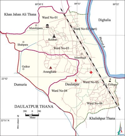
Daulatpur Thana
Daulatpur Thana (Khulna Metropolitan) area 13.62 sq km, located in between 22°50' and 22°54' north latitudes and in between 89°28' and 89°32' east longitudes. It is bounded by khan jahan ali thana on the north, khalishpur thana on the south, dighalia upazila and bhairab river on the east, dumuria upazila and Khan Jahan Ali thana on the west.
Population Total 118380; male 63066, female 55314; Muslim 104930, Hindu 12294, Buddhist 1144 and others 12.
Water bodies Main river: Bhairab.
Administration Daulatpur Thana was formed in 1917.
| Thana | |||||||||
| Ward and Union | Mahalla and Mouza | Population | Density (per sq km) | Literacy rate (%) | |||||
| Urban | Rural | Urban | Rural | ||||||
| 6+1 (part) | 34 | 107573 | 10807 | 10024 | 65.51 | 60.08 | |||
| Ward and Union | ||||||||
| Ward and Union | Area (sq km) | Population | Literacy rate (%) | |||||
| Male | Female | |||||||
| Ward No. 1 | 3.35 | 10613 | 9698 | 70.17 | ||||
| Ward No. 2 (part) | 0.75 | 7486 | 6152 | 69.27 | ||||
| Ward No. 3 | 3.20 | 12325 | 10691 | 63.14 | ||||
| Ward No. 4 | 2.02 | 7764 | 6535 | 66.36 | ||||
| Ward No.5 | 0.57 | 8201 | 7113 | 60.90 | ||||
| Ward No.6 | 0.49 | 11141 | 9854 | 63.24 | ||||
| Aranghata union 10 | 3.24 | 5536 | 5271 | 60.08 | ||||
Source Bangladesh Population Census 2001,Bangladesh Bureau of Statistics.

History of the War of Liberation At the end of May 1971, the Pak army killed 13 persons at a place near the Badamtali of Shiramoni.
Marks of the War of Liberation Sculpture 1 (Bir Bangali).
Religious institutions Mosque 18, temple 2, tomb 1.
Literacy rate and educational institutions Average literacy 66.85%; male 70.74%, female 62.41%. Noted educational institutions: BL College, Daulatpur Art College (1902), Daulatpur High School (1874), Mohsin Secondary School (1867), Maheshwarpasha KM Secondary School (1921), Maheshwarpasha Secondary Girls' School (1864).
Cultural organisations Club 6, cinema hall 1, playground 16.
Main sources of income Agriculture 4.47%, non-agricultural labourer 6.66%, industry 9.73%, commerce 26.02%, transport and communication 8.74%, service 24.25%, construction 2.42%, religious service 0.24%, rent and remittance 1.50% and others 15.97%.
Ownership of agricultural land Landowner 40.61%, landless 59.39%.
Main crops Paddy, jute, sugarcane, vegetables.
Extinct or nearly extinct crops betel leaf, potato.
Main fruits Mango, blackberry, jackfruit, litchi, betel nut, coconut, papaya, coconut.
Communication facilities 'railway 3.2 km.
Extinct or nearly extinct traditional transport Palanquin, horse carriage.
Noted manufactories Salt factory.
Cottage industries Goldsmith, blacksmith, potteries.
Hats, bazars and fairs Hats and bazars are 30.
Access to electricity All the wards and union of the thana are under electrification net-work. However 73.43% of the dwelling households have access to electricity.
Sources of drinking water Tube-well 96.82%, pond 0.13%, tap 2.07% and others 0.98%.
Sanitation 66.56% of dwelling households of the thana use sanitary latrines and 30.86% of dwelling households use non-sanitary latrines; 2.58% of households do not have latrine facilities
Main exports Salt, molasses.
Health centres Thana health complex 1, family planning centre 3, UFHP health centre 1. [Ekramul Kabir]
References Bangladesh Population Census 2001, Bangladesh Bureau of Statistics; Cultural survey report of' Daulatpur Thana 2007.
