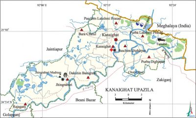
Kanaighat Upazila
Kanaighat Upazila (sylhet district) area 391.79 sq km, located in between 24°53' and 25°06' north latitudes and in between 92°01' and 92°26' east longitudes. It is bounded by Meghalaya state of India and jaintiapur upazila on the north, beanibazar and zakiganj upazilas on the south, Maghalaya state of India on the east, golapganj and Jaintiapur upazilas on the west.
Population Total 263969; male 129319, female 134650; Muslim 254940, Hindu 8730, Buddhist 6, Christian 248 and others 45. Indigenous communities such as manipuri and khasia belong to this upazila.
Water bodies Main rivers: Surma; Chatal Beel is notable.
Administration Kanaighat Thana was formed in 1932 and it was turned into an upazila in 1983.
| Upazila | ||||||||
| Municipality | Union | Mouza | Village | Population | Density (per sq km) | Literacy rate (%) | ||
| Urban | Rural | Urban | Rural | |||||
| 1 | 9 | 203 | 264 | 27078 | 236891 | 674 | 60.1 | 41.6 |
| Municipality | ||||||||
| Area (sq km) |
Ward | Mahalla | Population | Density (per sq km) |
Literacy rate (%) | |||
| 22.16 | 9 | 26 | 27078 | 1222 | 60.1 | |||
| Union | ||||
| Name of union and GO code | Area (acre) | Population | Literacy rate (%) | |
| Male | Female
| |||
| Kanaighat 47 | 7299 | 11516 | 11865 | 64.4 |
| Jhingrabari 38 | 15270 | 16258 | 17903 | 42.0 |
| Dakshin Banigram 19 | 8652 | 13900 | 15586 | 47.1 |
| Paschim Dighirpar 70 | 5005 | 7129 | 7390 | 44.2 |
| Paschim Lakshmi Prasad 66 | 9805 | 12150 | 12446 | 27.7 |
| Purba Dighirpar 76 | 8372 | 11383 | 11045 | 46.4 |
| Purba Lakshmi Prasad 72 | 15454 | 16032 | 15880 | 34.0 |
| Bara Chatul 09 | 11417 | 11469 | 11888 | 36.4 |
| Rajaganj 85 | 10885 | 15930 | 17121 | 36.7 |
Source Bangladesh Population Census 2011, Bangladesh Bureau of Statistics.
Historical events The annual Jalsha (religious fete) of the Kanaighat Madrasa was supposed to held on 23 March 1922 but the British government imposed ban on the event and declared 144 in and around the place. The organizers violated the 144 and the mob attacked the Commissioner. Six persons died and 38 were injured by police firing. The clash is known as ‘Kanaighater Larai’ (fight at Kanaighat).
War of Liberation During the war of liberation in 1971 the Pak army, in collaboration with the local razakars, conducted mass killing, mass torturing and plundering in different places of the upazila including at Maligram and Gouripur. Freedom fighter carried out an attack on the camp of razakars at Maligram and also had an encounter with the Pak army at Bhararimati. There is a mass killing site at Bishnupur and a mass grave at Bishnupur on the bank of a canal; a memorial monument has been built at Momtazganj.
For details: see কানাইঘাট উপজেলা, বাংলাদেশ মুক্তিযুদ্ধ জ্ঞানকোষ (Encyclopedia of Bangladesh War of Liberation), বাংলাদেশ এশিয়াটিক সোসাইটি,ঢাকা ২০২০, খণ্ড ২।

Religious institutions Mosque 491, temple 30, church 1. Noted religious institutions: Kanaighat Jami Mosque, Mangalpur Presbyterian Church.
Literacy rate and educational institutions Average literacy 43.5%; male 45.8%, female 41.4%. Educational institutions: college 3, technical college 1, primary training institute 1, secondary school 20, primary school 113, community school 8, kindergarten 14, madrasa 15. Noted educational institutions: Durgapur High School (1915), Jhingrabari Senior Madrasa (1882), Kanaighat Mansuria Senior Madrasa (1889), Gachbari Jamiul Ullum Alia Madrasa (1901), Soroker Bazar Ahmadia Alim Madrasa (1914).
Newspapers and periodicals Monthly Simanter Dak, Kanaighat Barta.
Cultural organisations Library 1, club 6, cultural organisation 1, women's organisation 7, auditorium 2, community centre 12, playground 4.
Tourist spots Tea garden, Patharkoari, Tamabil Land Port.
Main sources of income Agriculture 48.03%, non-agricultural labourer 11.49%, industry 0.42%, commerce 8.90%, transport and communication 0.95%, service 4.30%, construction 1.26%, religious service 1.20%, rent and remittance 12.61% and others 10.84%.
Ownership of agricultural land Landowner 56.15%, landless 43.85%; agricultural landowner: urban 53.96% and rural 56.20%.'
Main crops Paddy, tea, potato, cassia leaf, betel leaf, vegetables.
Extinct or nearly extinct crops Tobacco, jute, wheat.
Main fruits Jackfruit, pineapple, orange, lemon, shaddock, latkan, betel nut.
Fisheries, dairies and poultries This upazila has a number of fisheries, dairies and poultries.
Communication facilities Pucca road 129 km, semi-pucca road 500 km, mud road 656 km; waterway 20 km. Culvert 30, bridge 1.
Extinct or nearly extinct traditional transport Palanquin, horse carriage, bullock cart.
Cottage industries Goldsmith, blacksmith, potteries, cane work.
Hats, bazars and fairs Hats and bazars are 21, most noted of which are Kanaighat and Jhingrabari bazars.
Main exports Tea, betel leaf, stone, sand, cassia leaf.
Access to electricity All the wards and unions of the upazila are under rural electrification net-work. However 43.5% of the dwelling households have access to electricity.
Sources of drinking water Tube-well 24.5%, tap 0.9% and others 74.6%. The presence of intolerable level of arsenic has been detected in shallow tube-well water of the upazila and that is 27.46.
Sanitation 41.8% of dwelling households of the upazila use sanitary latrines and 48.2% of dwelling households use non-sanitary latrines; 10.0% of households do not have latrine facilities.
Health centres Upazila health complex 1, union health and family planning centre 8, community clinic 26, charitable dispensary 2, diagnostic centre 2, veterinary hospital 5.
NGO activities Operationally important NGOs are brac, asa, thengamara mahila sabuj sangha (tmss). [Jayanta Singh Roy]
References Bangladesh Population Census 2001 and 2011, Bangladesh Bureau of Statistics; Field report of Kanaighat Upazila 2010.
