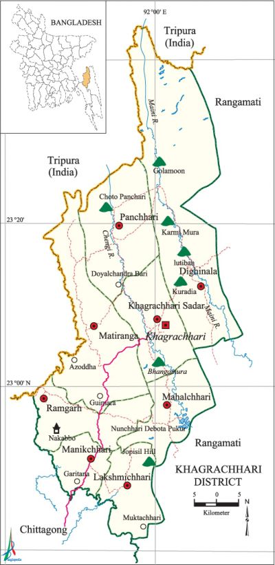
Khagrachhari District
Khagrachhari District (chittagong division) area 2505.73 sq km, located in between 22°38' and 23°44' north latitudes and in between 91°44' and 92°11' east longitudes. It is bounded by the tripura state of India on the north, rangamati and chittagong districts on the south, Rangamati district on the east, Chittagong district and Tripura state of India on the west. Notable hill ranges are Golamoon, Chotto Panchari, Karmi Mura, Lutiban, Kuradia, Bhanga Mura, Jopisil.
Population Total 569715; male 291390, female 278325; Muslim 261477, Hindu 93343, Buddhist 209932, Christian 3961 and others 1002. Indigenous communities such as chakma, marma, tripura and Tanchanga belong to this upazila.
Water bodies Main rivers: Maini, Chengi.
| District | |||||||||
| Area (sq km) | Upazila | Municipality | Union | Mouza | Village | Population | Density (per sq km) | Literacy rate (%) | |
| Urban | Rural | ||||||||
| 2505.73 | 8 | 3 | 35 | 108 | 1545 | 215808 | 353907 | 227 | 46.1 |
| Others Information of District | ||||||||
|
Name of Upazila |
Area |
Municipality |
Union |
Mouza |
Village |
Population |
Density |
Literacy rate (%) |
| Khagrachhari Sadar | 297.91 | 1 | 5 | 13 | 246 | 111833 | 375 | 57.1 |
| Dighinala | 694.11 | - | 5 | 22 | 245 | 103392 | 149 | 46.2 |
| Panchhari | 334.10 | - | 5 | 7 | 220 | 62198 | 186 | 42.3 |
| Mahalchhari | 186.48 | - | 4 | 9 | 154 | 42427 | 228 | 41.8 |
| Matiranga | 404.76 | 1 | 7 | 23 | 296 | 111538 | 276 | 42.4 |
| Manikchhari | 168.34 | - | 4 | 12 | 160 | 61589 | 366 | 40.7 |
| Ramgarh | 199.89 | 1 | 2 | 6 | 90 | 50744 | 254 | 41.3 |
| Lakshmichhari | 220.14 | - | 3 | 16 | 134 | 25994 | 118 | 35.2 |
Source Bangladesh Population Census 2011, Bangladesh Bureau of Statistics.
Administration The district of Chittagong Hill Tracts was established in 1860 under the 'Raid of Frontier Tribes Act 22 of 1860'. Following the district of Chittagong Hill Tract Regulation Act the Chittagong Hill Tract was divided into three sub-divisions (included Khagrachhari) in 1900. Khagrachhari sub-division was turned into district in 1983. The Khagrachhari Local Government Legislative Council was formed in 1989 (in accordance with the Khagrachhari Hill Districts Council, Act 20), which, on the basis of the historic 'Chittagong Hill Tracts Peace Accord', was turned into Khagrachhari Hill District Council on 2 December, 1997. '

War of Liberation An encounter was held between the freedom fighters and the Pak army in August 1971 in Ramgarh Upazila in which 17 Pak soldiers were killed. There is one mass grave in the upazila and one memorial plate and 2 memorial monumentsare erected.
Literacy rate and educational institutions Average literacy 46.1%; male 51.9%, female 40.1%. Noted educational institutions: Khagrachhari Government College (1974), Matiranga Degree College (1992), Ramgarh Government Degree College (1980), Panchhari College (1990), Dighinala Government College, Panchhari High School and College (1981), Khagrachhari Government High School (1957), Tabalchhari TK High School (1952), Ramgarh Government High School (1952),' Rani Nihar Devi Government High School (1976), Dighinala Government High School, Khagrachhari North Khobongpodia Government Primary School (1905).
Main sources of income Agriculture 59.92%, non-agricultural labourer 9.33%, industry 0.44%, commerce 10.67%, transport and communication 1.11%, service 7.94%, construction 0.92%, religious service 0.24%, rent and remittance 0.37% and others 9.06%.
Newspapers and periodicals Daily: Aranno Barta; weekly: Parboti, Chabuk, Parbotta Bani, Binnas.
Folkculture Biju festival of the Chakma, Sangri festival of the Marma and the Baisabi festival of the Tripura are most notable.
Tourists spots Ramgarh Lake and Suspicious Bridge, Rifles Memorial Monument (Ramgarh),' Alu Tila (Khagrachhari Sadar and Matiranga). [Barendro Lal Tripura]
See also The upazilas under this district.
References Bangladesh Population Census 2001 and 2011, Bangladesh Bureau of Statistics; Cultural survey report of Khagrachhari District 2007; Cultural survey report of Upazilas of Khagrachhari District 2007.
