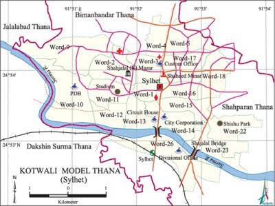
Kotwali Model Thana (Sylhet Metropolitan)
Kotwali Model Thana (Sylhet Metropolitan) area 17.22 sq km, located in between 23°38' and 23°48' north latitudes and in between 89°50' and 90°03' east longitudes. It is bounded by jalalabad and bimanbandar thanas on the north, dakshin surma thana on the south, shah paran thana on the east, Dakshin Surma and Jalalabad thanas on the west.
Population Total 168271; male 95044 female 73227; Muslim 146340, Hindu 21429, Buddhist 206, Christian 152 and others 144.
Water bodies Main rive: Surma.
Administration Kotwali Model Thana was established on 12 December 1983.
| Thana | ||||||
| Ward | Mohalla | Population | Density (per sq km) | Literacy rate (%) | ||
| Urban | Rural | Urban | Rural | |||
|
18 |
144 |
168271 |
- |
9772 |
71.75 |
- |
| Ward | ||||
| Name number of Ward | Area (sq km) | Population | Literacy rate (%) | |
| Male | Female | |||
|
Word no. 1 |
0.95 |
5992 |
4181 |
74.87 |
|
Word no. 2 |
1.00 |
3608 |
2930 |
83.19 |
|
Word no. 3 |
0.92 |
4838 |
3668 |
83.79 |
|
Word no. 4 |
0.94 |
3535 |
2892 |
76.88 |
|
Word no. 5 |
0.93 |
6028 |
5412 |
64.98 |
|
Word no. 9 |
1.00 |
6746 |
4984 |
63.67 |
|
Word no. 10 |
0.90 |
6277 |
5586 |
48.15 |
|
Word no. 11 |
0.88 |
4730 |
4300 |
79.83 |
|
Word no. 12 |
0.91 |
5415 |
4590 |
72.58 |
|
Word no. 13 |
0.90 |
4020 |
2781 |
71.82 |
|
Word no. 14 |
0.90 |
8906 |
5162 |
55.70 |
|
Word no. 15 |
0.92 |
9399 |
4953 |
77.82 |
|
Word no. 16 |
0.97 |
5748 |
4844 |
75.58 |
|
Word no. 17 |
0.94 |
6750 |
5445 |
80.54 |
|
Word no. 18 |
0.90 |
6242 |
5578 |
70.69 |
|
Word no. 22 |
0.95 |
3396 |
2854 |
84.24 |
|
Word no. 23 |
0.96 |
2014 |
1803 |
62.09 |
| Word no. 26 | 1.35 | 1400 | 1264 | 65.02 |
Source Bangladesh Population Census 2001, Bangladesh Bureau of Statistics.
Archaeological heritage and relics Mazar of Hazrat shah jalal (R).
Religious institutions Mosque 260, temple 26, church 2, mazar 16.

Literacy rate and educational institutions Average literacy 71.75%; male 75.22%, female 67.33%; university 4, college 7, secondary school 35, primary school 61, madrasa 23. Noted educational institutions: Sylhet Sanskrit College, (1902), MAG Osmani Medical College (1975), Sylhet Women's Medical College, Madan Mohan College, Government Women's College, Ambarkhana Government High School, The Aided High School, Police Line School.
Cultural organisation Library 2, cinema hall 6, women's organisation 9, theatre group 5, playground 1.
Noted establishments Shahi Eidgah, Keen Bridge, Monipuri Palace, Sylhet Central Jail, Government Shishu Sadan, Circuit House, Bangladesh Bank, Nagar Bhaban, Zila Education Building, Radio and Television Relay Centre, Weather Office, Osmani Memorial Museum, Osmani Stadium, Sylhet Children Park, Sylhet Wonderland.
Main source of income Agriculture 2.84%, non-agricultural labourer 3.35%, industry 1.59%, commerce 32.86%, transport and communication 5.48%, service 26.99%, construction 3.06%, religious service 0.19%, rent and remittance 6.52% and others 17.12%.
Ownership of agricultural land Owner of land 40.79%, landless 59.21%.
Main crops Rice, vegetables.
Main fruits Mango, jackfruit, blackberry, guava, banana.
Fisheries, dairies, poultries Fishery 45, dairy 50 and poultry 57.
Communication facilities Road: pucca 72.52 km, semi pucca 18.77 km, mud road 170. 72 km; waterway 23 nautical mile.
Extinct or nearly extinct traditional transport Bulloock cart and horse carriage.
Hats, bazars and shopping centres 25, most noted of which are Shahjalal Super Market, Sylhet Plaza, Laldighi Hawker's Market, Hafiz Complex, Municipal Market, Alhamra Shopping City, Rikabi Bazar and West Kazi Bazar.
Hotel and restaurant Agra Hotel and Restaurant.
Access to electricity All the wards of the thana are under electrification net-work. However, 84.52% of the dwelling households have access to electricity.
Sources of drinking water Tube-well 65.76%, tap water' 32.74%, pond 0.17% and others 1.33%.
Sanitation 84.21% of dwelling households of the upazila use sanitary latrines and 14.93% of dwelling houses use non-sanitary latrines; 0.86% of households do not have latrine facilities.
Health centres Hospital 4, satellite clinic 2, clinic 40.
NGO activities brac, FIVDB, bard, Save the Children, CARE, Organisation for Children. [Sirajul Islam]
References Bangladesh Population Census 2001, Bangladesh Bureau of Statistics.
