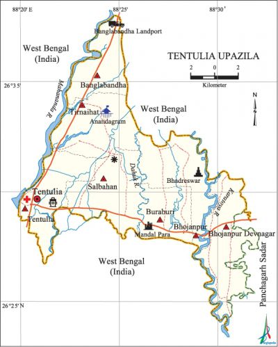
Tentulia Upazila
Tentulia Upazila (panchagarh district) area 189.10 sq km, located in between 26°24' and 26°38' north latitudes and in between 88°21' and 88°33' east longitudes. Extreme northern upazila of Bangladesh is bounded by west bengal state of India on the north, south and west, panchagarh sadar upazila on the east.
Population Total 125454; male 63463, female 61991; Muslim 122821, Hindu 2335, Buddhist 10, Christian 206 and others 82. Indigenous communities such as santal and rajbangshi belong to this upazila.
Water bodies Main rivers: Dahuk, karatoya, mahananda.
Administration Tentulia Thana was formed on 26 June 1917 and it was turned into an upazila on 16 March 1993.
| Upazila | ||||||||
| Municipality | Union | Mouza | Village | Population | Density (per sq km) | Literacy rate (%) | ||
| Urban | Rural | Urban | Rural | |||||
| - | 7 | 33 | 246 | 5506 | 119948 | 663 | 64.0 | 46.5 |
| Upazila Town | |||||
|
Area (sq km) |
Mouza |
Population |
Density (per sq km) |
Literacy rate (%) | |
| 4.23 | 1 | 5506 | 1302 | 64.0 | |
| Union | ||||
| Name of union and GO code | Area (acre) | Population | Literacy rate (%) | |
| Male | Female | |||
| Tirnaihat 94 | 7493 | 8960 | 8849 | 46.0 |
| Tentulia 81 | 6309 | 10151 | 10054 | 49.3 |
| Banglabandha 13 | 5194 | 7660 | 7293 | 48.2 |
| Buraburi 54 | 6280 | 5859 | 5800 | 45.7 |
| Debnagar 40 | 8233 | 11771 | 11402 | 45.0 |
| Bhojanpur 27 | 5589 | 8566 | 8138 | 46.7 |
| Salbahan 67 | 7632 | 10496 | 10455 | 49.8 |
Source Bangladesh Population Census 2011, Bangladesh Bureau of Statistics.

Archaeological heritage and relics Bhadreswar Temple, Shiva Temple, Mausoleum built as per design of the Greek architecture, Tentulia Dakbungalow.
War of Liberation Tentulia was under Sector 6 of the War of Liberation in 1971. Freedom fighters did not have direct encounter with Pak army in the upazila but from Magurmari, Debnagar, and Moynakuri to they often carried out operations in Jagadal, Amarkhan, Mirgarh and some other places of adjacent upazila.
For details: see Asiatic Society of Bangladesh, বাংলাদেশ মুক্তিযুদ্ধ জ্ঞানকোষ (Encyclopedia of Bangladesh War of Liberation, Bangla Version, Vol. 4), Tentulia upazila.
Religious institutions Mosque 120, temple 2.
Literacy rate and educational institutions Average literacy 47.3%; male 49.9%, female 44.7%. Educational institutions: college 4, secondary school 27, primary school 67, kindergarten 3, madrasa 11. Noted educational institutions: Kazi Shahabuddin Girls' School and College (1965), Tentulia College (1986), Bhojanpur' Degree College (1987), Tentulia Technical College (2004), Boda Mainaguri Bilateral High School (1917), Bhojanpur Bilateral High School (1956), Salbahan Bilateral High School (1962), Tentulia Pilot High School (1959), Majhipara Bilateral High School (1973), Haradighi Bilateral High School (1969), Kalandiganj Senior Madrasa (1976), Begum Fakhrunnisa Fazil Madrasa (1978).
Cultural organisations Library 1, club 16, music school 1, cinema hall 1, theatre group 1.
Amusement centres Tentulia Picnic Corner, Dahuk Picnic Centre, Anandadhara and Tea Garden at Raushanpur,' Zero Point and Landport at Banglabandha.
Main sources of income Agriculture 61.72%, non-agricultural labourer 16.01%, commerce 8.84%, transport and communication 2.33%, service 4.38%, construction 0.46%, religious service 0.09%, rent and remittance 0.09% and others 6.08%.
Ownership of agricultural land Landowner 54.75%, landless 45.25%; agricultural landowner: urban 39.45% and rural 55.51%.'
Main crops Paddy, jute, wheat, sugarcane, potato, garlic, vegetables.
Extinct or nearly extinct crops Kaun, barley, mustard, sweet potato, arahar, linseed.
Main fruits Mango, blackberry, jackfruit, litchi, watermelon, papaya, pineapple, orange.
Communication facilities Pucca road 101 km, mud road 364.5 km.
Extinct or nearly extinct traditional transport Palanquin, horse carriage, bullock cart.
Cottage industries Potteries, weaving, jute work, bamboo work.
Hats, bazars and fairs Hats and bazars are 14, most noted of which are Tentulia Bazar, Salbahan Hat, Bhojanpur Hat, Sepaipara Hat, Tirnaihat, Buraburi Hat and Muhurir Hat.
Main exports Watermelon, pineapple, jackfruit, papaya, garlic, gravel.
Access to electricity All the unions of the upazila are under rural electrification net-work. However 22.3% of the dwelling households have access to electricity.
Natural resources Glass Sand, Bolder Stone, stone chips.
Sources of drinking water Tube-well 93.1%, tap 0.4% and others 6.5%.
Sanitation 72.4% of dwelling households of the upazila use sanitary latrines and 15.6% of dwelling households use non-sanitary latrines; 12.0% of households do not have latrine facilities.
Health centres Upazila health complex 1, family planning centre 6, satellite clinic 3.
Natural disasters The earthquake of 1942 and the flood of 1968 caused heavy damages to settlements and other properties of the upazila.
NGO activities Operationally important NGOs are brac, RDRS. [Shahidul Islam Shahid]
References Bangladesh Population Census 2001 and 2011, Bangladesh Bureau of Statistics; Cultural survey report of Tentulia Upazila 2007.
