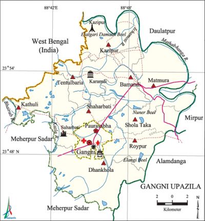
Gangni Upazila
Gangni Upazila (meherpur district) area 363.95 sq km, located in between 23°44' and 23°52' north latitudes and in between 88°34' and 88°47' east longitudes. It is bounded by daulatpur (kushtia) upazila on the north, alamdanga and meherpur sadar upazilas on the south, Daulatpur (Kushtia), mirpur (Kushtia) and' Alamdanga upazilas on the east, Meherpur Sadar upazila and west bengal state of India on the west.
Population Total 299607; male 148250, female 151357; Muslim 295458, Hindu 2726, Christian 1313 and others 110.
Water bodies Main rivers: bhairab, ichamati, Mathabhanga and Kazla; Elangi Beel, Nuner Beel and Elalgari Damash Beel are notable.
Administration Gangni Thana was formed in 1923 and it was turned into an upazila on 24 February 1984.'
| Upazila | ||||||||
| Municipality | Union | Mouza | Village | Population | Density (per sq km) | Literacy rate (%) | ||
| Urban | Rural | Urban | Rural | |||||
| 1 | 9 | 90 | 137 | 30239 | 269368 | 823 | 50.00 (2001) | 40.5 |
| Municipality | ||||||||
|
Area |
Ward |
Mahalla |
Population |
Density |
Literacy rate (%) | |||
| 12.17 (2001) | 9 | 29 | 25500 | 1707.47 (2001) | 59.6 | |||
| Upazila Town | ||||||||
|
Area |
Mouza |
Population |
Density |
Literacy rate (%) | ||||
| 22.86 (2001) | 2 | 4739 | 1043 (2001) | 45.1 | ||||
| Union | ||||
| Name of union and GO code | Area (acre) | Population | Literacy rate (%) | |
| Male | Female | |||
| Kazipur 52 | 13580 | 19220 | 20591 | 39.1 |
| Kathuli 42 | 8211 | 11103 | 11276 | 39.6 |
| Tentulbaria 94 | 8387 | 15049 | 15814 | 38.8 |
| Dhankhola 21 | 14331 | 20709 | 20623 | 40.2 |
| Bamandi 10 | 7505 | 13377 | 13399 | 42.8 |
| Matmura 63 | 11720 | 22290 | 22319 | 41.8 |
| Shola Taka 84 | 7998 | 12148 | 12385 | 41.6 |
| Shaharbati 73 | 6934 | 11442 | 11697 | 42.1 |
| Roypur 31 | 7096 | 10191 | 10474 | 39.5 |
Source Bangladesh Population Census 2001 and 2011, Bangladesh Bureau of Statistics.
Archaeological heritage and relics Shaharbati Neelkuthi (1859), Gosaidubi Mosque at Karamdi.
War of Liberation Freedom fighters had a number of encounters with the Pak army in the upazila and notable among these were at Ramnagar, Tetulbaria, Kazipur, Paglarpul and Bamundi Camp. There are mass graves at two places (Kazipur and Tepukhali playground) of the upazila.
For details: see গাংনী উপজেলা, বাংলাদেশ মুক্তিযুদ্ধ জ্ঞানকোষ (Encyclopedia of Bangladesh War of Liberation), বাংলাদেশ এশিয়াটিক সোসাইটি, ঢাকা ২০২০, খণ্ড ৩।
Religious institutions Mosque 245, temple 6, church 6.
Literacy rate and educational institutions Average literacy 42.2%; male 42.7%, female 41.7%. Educational institutions: college 9, secondary school 68, primary school 164, kindergarten 14, community school 4, madrasa 9. Noted educational institutions: Gangni Degree College (1983), Gangni Mohila College (1995), Hoglabaria Mohammadpur Hazi Bharasuddin Secondary School (1945), Gangni Secondary School (1945).

Cultural organisations Library 4, club 10, music learning institution 3, theatre group 2, cinema hall 2, playground 20.
Tourist spots Bhatpara Neelkuthi and Chitla Jute Seed Farm.'
Main sources of income Agriculture 70%, non-agricultural labourer 2.83%, industry 0.96%, commerce 13.38%, transport and communication 1.90%, service 3.13%, construction 1.03%, religious service 0.13%, rent and remittance 0.59% and others 6.05%.
Ownership of agricultural land Landowner 57.82%, landless 42.18%; agricultural landowner: urban 59.02% and rural 57.71%.
Main crops Paddy, jute, wheat, tobacco, maize, vegetables.
Extinct or nearly extinct crops Indigo, arahar, khesari pulse.
Main fruits Mango, jackfruit, litchi.
Fisheries, dairies and poultries This upazila has a number of fisheries, dairies, poultries and hatcheries.'
Communication facilities Pucca road 244 km, semi-pucca road 88 km, mud road 384 km.
Extinct or nearly extinct traditional transport Palanquin, bullock cart, horse carriage.
Noted manufactories Flour mill, jute mill, ice factory.
Cottage industries Weaving, blacksmith, potteries, bamboo work, wood work, nakshi kantha.
Hats, bazars and fairs Hats and bazars are 20, fair 1, most noted of which are Garabari Hat, Tentulbaria Hat, Karamdi Hat, Kazipur Hat, Betbaria Hat, Naodapara Hat and Baishakhi Mela.
Main exports Tobacco, paddy, jute, wheat.
Access to electricity All the wards and unions of the upazila are under rural electrification net-work. However 59.0% of the dwellings have access to electricity.
Sources of drinking water Tube-well 96.2%, tap 0.5% and others 3.3%. The presence of arsenic has been detected in 12.02% out of the 31965 shallow tube-wells of the upazila.
Sanitation 39.5% of dwelling households of the upazila use sanitary latrines and 51.9% of dwelling households use non-sanitary latrines; 8.6% of households do not have latrine facilities.
Health centres Upazila health complex 1, satellite clinic and family planning centre 6, hospital 1, clinic 5, health centre 1.
NGO activities proshika, brac, asa, Sandhani, Nijera Kari. [Rajib Ahmed]
References Bangladesh Population Census 2001 and 2011, Bangladesh Bureau of Statistics; Cultural survey report of Gangni Upazila 2007.
