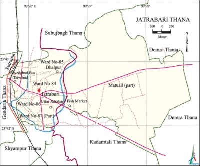
Jatrabari Thana
Jatrabari Thana (Dhaka metropolitan) area 13.19 sq km, located in between 23°42' and 23°43' north latitudes and in between 90°20' and 90°22' east longitudes. It is bounded by sabujbagh and demra thanas on the north, kadamtali and shyampur thanas on the south, Demra thana on the east, gandaria and sutrapur thanas on the west.
Population Total 260772; male 146920, female 113852; Muslim 254479, Hindu 5828, Buddhist 370, Christian 57 and others 38.
Water bodies Main river: balu.
Administration Jatrabari Thana was formed in 2007.
| Thana | ||||||||
| Ward and Union | Mahalla and Mouza | Population | Density (per sq km) | Literacy rate (%) | ||||
| Urban | Rural | Urban | Rural | |||||
| 3+2 | 17 | 260772 | - | 19770 | 63.04 | - | ||
| Ward and Union | ||||||||
| Ward and Union | Area (sq km) | Population | Literacy rate (%) | |||||
| Male | Female | |||||||
| Ward No 84 | 0.80 | 24120 | 16564 | 65.43 | ||||
| Ward No 85 | 1.12 | 24347 | 20540 | 54.31 | ||||
| Ward No 86 | 1.04 | 29288 | 22017 | 70.50 | ||||
| Ward No 87 (Part) | 0.45 | 12433 | 9261 | 62.17 | ||||
| Matuail union (Part) | 9.78 | 56732 | 45470 | 62.79 | ||||
Source Bangladesh Population Census 2001, Bangladesh Bureau of Statistics.

Religious institutions Babar Mosque, Baitul Aman Mosque, Dalpur Jakarin Jami Mosque are notable.
Literacy rate and educational institutions Average literacy 63.04%; Male 76.01%, female 65.69%. Noted educational institutions: Matuail Latif Bhuiyan College, Matuail Girls' High School, Adarsha High School, Jatrabari Ideal High School, Dhulaipar High School.
Cultural organisations Jatrabari park.
Important installations Saidabad bus terminal.
Main sources of income Agriculture 1.84%, non-agricultural labourer 1.67%, industry 2.49%, commerce 29.02%, transport and communication 12.65%, construction 3.22%, religious service' 0.15%, service 29.94%, rent and remittance 3% and others 11.8%.
Ownership of agricultural land Landowner 50.65%, landless 49.65%.
Main crops Paddy, potato, vegetables.
Extinct and nearly extinct crops Jute, sesame, linseed.
Main fruits Jackfruit, guava, coconut, papaya, plum, banana.
Communication facilities Total road 49.78 km.
Extinct or nearly extinct traditional transport Palanquin, bullock cart.
Manufactories Garments industries, ice factory, rice mill.
Hats, bazars and markets' Jatrabari Bazar is notable.
Main exports Ready made garments, fish.
Access to electricity All the wards and unions of the thana are under electrification net-work. However 97.96% of the dwelling households have access to electricity.
Sources of drinking water Tube-well 43.15%, tap 55.91%, pond 0.13% and others 0.81%.
Sanitation 91.09% of dwelling households of the thana use sanitary latrines and 8.40% of dwelling household use non-sanitary latrines; 0.51% of households do not have latrine facilities.
Heath centres Hospital 2, clinic 4. Speed Bangladesh Clinic, Desh Diagnostic Centre are notable.
NGO activities brac, asa, proshika. [Shamima Akhter]
References Bangladesh Population Census 2001, Bangladesh Bureau of Statistics.
