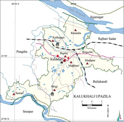
Kalukhali Upazila
Kalukhali Upazila (rajbari district) area 168.81 sq km, located in between 23°39' and 23°49' north latitudes and in between 89°21' and 89°35' east longitudes. It is bounded by sujanagar upazila on the north, sreepur and baliakandi upazilas on the south, Baliakandi and rajbari sadar upazilas on the east, pangsha upazila on the west.
Population Total 155044; male 77205, female 77839; Muslim 143144, Hindu 11841, Christian 15 and others 44.
Water bodies Main rivers: padma, Gorai.
Administration Kalukhali Upazila was formed on 24 September 2006 comprising part of Pangsha upazila.
| Upazila | ||||||||
| Municipality | Union | Mouza | Village | Population | Density (per sq km) | Literacy rate (%) | ||
| Urban | Rural | Urban | Rural | |||||
| - | 7 | 157 | 156 | 4223 | 150821 | 918 | 66.9 | 50.7 |
| Upazila Town | ||||
| Area (sq km) | Mouza | Population | Density (per sq km) | Literacy rate (%) |
| - | 2 | 4223 | - | 66.9 |
| Union | ||||
| Name of union and GO code | Area (acre) | Population | Literacy rate (%) | |
| Male | Female | |||
| Kalikapur 30 | 3618 | 7344 | 7605 | 51.8 |
| Boalia 18 | 5579 | 10917 | 11197 | 51.8 |
| Majhbari 55 | 5470 | 9431 | 9593 | 48.0 |
| Madapur 60 | 5478 | 9314 | 9555 | 55.8 |
| Mrigi 70 | 6034 | 12205 | 11973 | 56.4 |
| Ratandia 85 | 9026 | 14634 | 14828 | 46.3 |
| Saorail 95 | 6510 | 13360 | 13088 | 50.0 |
Source Bangladesh Population Census 2011, Bangladesh Bureau of Statistics.
War of Liberation In order to disrupt free movement of the Pakistani soldiers in the Upazila area, the freedom fighters had blasted off bridges and uprooted railway lines at different places. Many freedom fighters got organized and attacked the local police station, from which they captured arms and ammunition. Freedom fighters had also carried out guerilla attacks and small operations during the entire period of the War of Liberation. There is a mass killing site at a place near Kalukhali Railway Station.
For details: see কালুখালী উপজেলা, বাংলাদেশ মুক্তিযুদ্ধ জ্ঞানকোষ (Encyclopedia of Bangladesh War of Liberation), বাংলাদেশ এশিয়াটিক সোসাইটি, ঢাকা ২০২০, খণ্ড ২।
Religious institutions Mosque 57, temple 13.
Literacy rate and educational institutions Average literacy 51.2%; male 52.5%, female 49.9%. Educational institutions: college 3, secondary school 20, primary school 45, madrasa 19. Noted educational institutions: Mrigi Shaheed Dianot Degree College, Kalukhali College, Majhbari Jahanara Beugm College, Ratandia Rajanikantha High School (1920), Bangladesh Hat Nesaria Dakhil Madrasha, Hogladangi Mohammadia Islamia Kamil Madrasah, Charkultia Siddikia Dakhil Madrasha, Majbari Siddikia Seratul Haque Alim Madrasha, Surjadia Dakil Madrasha, Kalukhali Dakhil Madrasha, Bastopur Mohammadia Dakhil Madrasha, Arkandi Shohid Muktijoddah Dakhil Madrasha, Sangram Pur Dakhil Madrasah, Paturia Dakhil Madrasah.

Cultural organisations Library 10, club 25, women organisation 1, playground 1.
Main sources of income Agriculture 42.01%, non-agricultural labourer 7.41%, industry 1.27%, commerce 21.31%, transport and communication 4.55%, service 10.61%, construction 1.78%, religious service 0.26%, rent and remittance 0.54% and others 10.26%.
Ownership of agricultural land Landowner 56.38%, landless 43.62%.
Main crops Paddy, wheat, jute, sugarcane, potato, vegetables.
Extinct or nearly extinct crops Aus paddy.
Main fruits Mango, jackfruit, banana, papaya, safeda, jamrul, blackberry, coconut.
Fisheries, dairies and poultries Dairy 42, poultry 60, fishery 30.
Communication facilities Pucca road 494 km, semi-pucca road 134 km, mud road 1365 km; railway 10 km; waterway 12 km. Railway station 1.
Extinct or nearly extinct traditional transport Palanquin, horse carriage, bullock cart.
Noted manufactories Rice mill, fish feed mill, ice factory, welding.
Cottage industries Goldsmith, blacksmith, potteries, wood work, bamboo work, tailoring, nakshi kantha.
Hats, bazars and fairs Hats and bazars are 31, fairs 5, most noted of which are Gate Bazar, Kalikapur Bazar, Milat Bazar, Dattapara Bazar, Haribhanga Bazar, Panchtickri Bazar, Fultala Bazar, Paturia Bazar, Banjana Bazar, Chandpur Bazar, Gadimara Hat, Goutompur Hat, Nutun Hat, Baribaria Hat, Bangladesh Hat, Mohanpur Hat, Madapur Hat, Hatgram Hat and Durga Puja Mela and Paus Mela.
Main exports Paddy, jute, sugarcane.
Access to electricity All the unions of the upazila are under rural electrification net-work. However 42.2% of the dwelling households have access to electricity.
Sources of drinking water Tube-well 97.7%, tap 0.2% and others 2.1%.
Sanitation 79.3% of dwelling households of the upazila use sanitary latrines and 17.3% of dwelling houses use non-sanitary latrines; 3.4% of households do not have latrine facilities.
Health centres Union health and family planning centre 1, family welfare centre 1, community clinic 2.
NGO activities Operationally important NGOs are brac, proshika, asa. [Rajib Mondal]
References Bangladesh Population Census 2001 and 2011, Bangladesh Bureau of Statistics; Field report of Kalukhali Upazila 2012.
