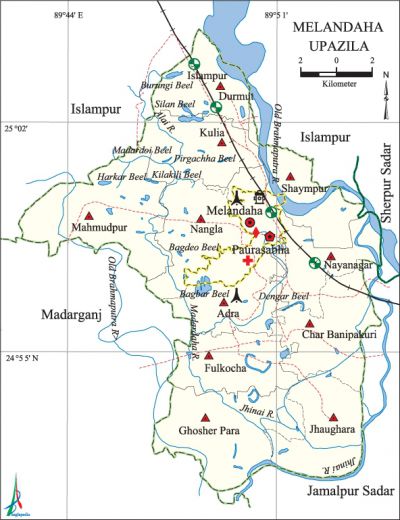
Melandaha Upazila
Melandaha Upazila (jamalpur district) area 258.32 sq km, located in between 24°51' and 25°50' north latitudes and in between 89°42' and 89°53' east longitudes. It is bounded by islampur upazila on the north, jamalpur sadar and madarganj upazilas on the south, Jamalpur Sadar, sherpur sadar and Islampur upazilas on the east, Madarganj and Islampur upazilas on the west.
Population Total 313182; male 154110, female 159072; Muslim 309219, Hindu 3872, Buddhist 1, Christian 11 and others 79.
Water bodies Main rivers: Jhinai, old brahmaputra, Madardaha; Burungi, Silan, Pirgachha, Harkar, Kilakili, Bagbar and Bagdeo beels and Chatal Canal are notable.
Administration Melandaha Thana was formed on 21 May 1925 and it was turned into an upazila on 15 April in 1983.
| Upazila | ||||||||
| Municipality | Union | Mouza | Village | Population | Density (per sq km) | Literacy rate (%) | ||
| Urban | Rural | Urban | Rural | |||||
| 1 | 11 | 132 | 199 | 36322 | 276860 | 1212 | 33.7 (2001) | 34.6 |
| Municipality | ||||||||
|
Area (sq km) |
Ward |
Mahalla |
Population |
Density (per sq km) |
Literacy rate (%) | |||
| 12.96 (2001) | 9 | 31 | 31320 | 2215 (2001) | 45.7 | |||
| Upazila Town | ||||||||
|
Area (sq km) |
Mouza |
Population |
Density (per sq km) |
Literacy rate (%) | ||||
| 5.41 (2001) | 1 | 5002 | 1003 (2001) | 30.1 | ||||
| Union | ||||
| Name of union and GO code | Area (acre) | Population | Literacy rate (%) | |
| Male | Female | |||
| Adra 17 | 4735 | 10410 | 10912 | 37.1 |
| Kulia 66 | 5489 | 11576 | 12236 | 32.8 |
| Ghosher Para 47 | 7581 | 16722 | 17549 | 38.0 |
| Char Banipakuri 19 | 6469 | 15220 | 15782 | 36.5 |
| Jhaugara 57 | 5391 | 14222 | 14786 | 37.8 |
| Durmut 28 | 4152 | 10525 | 10862 | 33.4 |
| Nayanagar 95 | 4747 | 10443 | 10606 | 33.5 |
| Nangla 85 | 3955 | 11002 | 11465 | 28.9 |
| Fulkocha 38 | 4741 | 12081 | 12703 | 39.5 |
| Mahmudpur 76 | 8272 | 18541 | 19552 | 31.2 |
| Shaympur 97 | 4460 | 7488 | 7179 | 26.2 |
Source Bangladesh Population Census 2001 and 2011, Bangladesh Bureau of Statistics.

Archaeological heritage and relics Remnants of Neelkuthi at Basuria, remnants of kacharis (revenue offices) and dighis of Fulkocha and Mohiramkul zamindars.
War of Liberation The freedom fighters conducted guerrilla operation at Dewanganj of the upazila sometime in the mid-period of the war of liberation. They had encounters with the Pak army at places like Khasimara village, Durmuthat, mahmudpur village and the Poyla Bridge area. Mass graves had been discovered at 4 places (Adipoita, Kayetpara, Konamalancha, Char Govindapur) of the upazila.
For details: see মেলান্দহ উপজেলা, বাংলাদেশ মুক্তিযুদ্ধ জ্ঞানকোষ (Encyclopedia of Bangladesh War of Liberation), বাংলাদেশ এশিয়াটিক সোসাইটি, ঢাকা ২০২০, খণ্ড ৮।
Religious institutions Mosque 519, temple 7.
Literacy rate and educational institutions Average literacy 35.7%; male 38.8%, female 32.7%. Educational institutions: college 7, technical college 3, secondary school 42, primary school 135, community school 8, kindergarten 12, NGO school 50, madrasa 53. Noted educational institutions: Melandaha Government Degree College (1972), Hajrabari Sirajul Haque Degree College (1976), Hajrabari High School (1926), Melandaha Umir Uddin Pilot Higher Secondary School (1937), Fulkocha Multilateral High School (1951), Melandaha Government Girls' High School (1963).
Newspapers and periodicals Weekly: Jhinai, Utshomukh, Shilpo-Shahitta Patro (defunct); monthly: Chonder Jhinai.
Cultural organisations Library 5, club 41, theatre group 2, cinema hall 5, women's organisation 2, playground 11.
Main sources of income Agriculture 70.50%, non-agricultural labourer 3.02%, industry 0.44%, commerce 10.33%, transport and communication 2.58%, service 4%, construction 1%, religious service 0.17%, rent and remittance 0.23% and others 7.73%.
Ownership of agricultural land Landowner 56.08%, landless 43.92%; agricultural landowner: urban 37.12% and rural 58.50%.
Main crops Paddy, jute, wheat, mustard, sugarcane, potato, chilli, ground nut, gram, black gram, tobacco, betel leaf, vegetables.
Extinct or nearly extinct crops Corn, sesame, kaun, linseed.
Main fruits Mango, jackfruit, coconut, banana, papaya, betel nut.
Fisheries, dairies and poultries Dairy 3, poultry 11, hatchery 6.
Communication facilities Pucca road 188 km, semi-pucca road 21 km, mud road 393 km; railway 20 km.
Extinct or nearly extinct traditional transport Palanquin, soari.
Cottage industries Blacksmith, nakshi kantha, bamboo work, cane work.
Hats, bazars and fairs Hats and bazars are 16, most noted of which are Melandaha Bazar, Hajrabari Bazar and Jhaugara Bazar.
Main exports Paddy, jute, potato, molasses, ground nut, chilli, gram.
Access to electricity All the wards and unions of the upazila are under rural electrification net-work. However 40.8% of the dwelling households have access to electricity.
Sources of drinking water Tube-well 97.8%, tap 0.1% and others 2.1%.
Sanitation 63.6% of dwelling households of the upazila use sanitary latrines and 29.2% of dwelling households use non-sanitary latrines; 7.2% of households do not have latrine facilities.
Health centres Upazila health complex 1, satellite clinic 2, family planning centre 9, union health centre 8, community clinic 19, diagnostic centre 5.
Natural disasters The tornado of 1991 caused heavy damages to settlements and crops of Jhaugara union of the upazila.
NGO activities Operationally important NGOs are brac, asa, CARE. [Sayed Md Abdullah Al Mamun Chowdhury]
References Bangladesh Population Census 2001 and 2011, Bangladesh Bureau of Statistics; Cultural survey report of Melandaha Upazila 2007.
