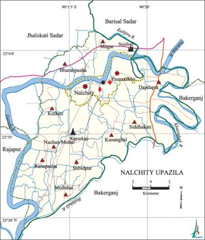
Nalchity Upazila
Nalchity Upazila (jhalokati district) area 231.42 sq km, located in between 22°29' and 22°42' north latitudes and in between 90°11' and 90°23' east longitudes. It is bounded by jhalokati sadar and barisal sadar upazilas on the north, bakerganj upazila on the south, Barisal Sadar and Bakerganj upazilas on the east, rajapur and Jhalokati Sadar upazilas on the west.
Population Total 193556; male 92131, female 101425; Muslim 184086, Hindu 9391, Christian 72 and others 7.
Water bodies Main rivers: nalchity, bishkhali, Khairabad, Gazalia, Kalijira.
Administration Nalchity Thana was formed in 1924 and it was turned into an upazila in 1983.
| Upazila | ||||||||
| Municipality | Union | Mouza | Village | Population | Density (per sq km) | Literacy rate (%) | ||
| Urban | Rural | Urban | Rural | |||||
| 1 | 10 | 119 | 138 | 30805 | 162751 | 836 | 66.1 | 67.4 |
| Municipality | ||||||||
|
Area (sq km) |
Ward |
Mahalla |
Population |
Density (per sq km) |
Literacy rate (%) | |||
| 23.32 | 9 | 21 | 30805 | 1321 | 66.1 | |||
| Union | ||||
| Name of union and GO code | Area (acre) | Population | Literacy rate (%) | |
| Male | Female | |||
| Kulkati 21 | 4973 | 7566 | 8151 | 71.5 |
| Kusanghal 31 | 4437 | 7494 | 8368 | 63.3 |
| Dapdapia 15 | 7727 | 12829 | 13716 | 64.2 |
| Nachan Mohal 52 | 3418 | 6301 | 7169 | 59.4 |
| Bharabpasha 13 | 4167 | 7828 | 8180 | 69.7 |
| Magar 42 | 4365 | 7911 | 8874 | 69.2 |
| Mollahat 36 | 4824 | 7611 | 8629 | 71.0 |
| Ranapasha 73 | 4251 | 5373 | 6127 | 69.8 |
| Siddhakati 84 | 4440 | 7310 | 8207 | 71.2 |
| Subidpur 94 | 4348 | 7202 | 7905 | 66.6 |
Source Bangladesh Population Census 2011, Bangladesh Bureau of Statistics.

Archaeological heritage and relics Sujabad Kella (1639), Civil Court Building (1781), Tara Temple and Zamindar Bari (Baroikaran).'
Historical events 19 Muslims were killed in an encounter with the British army at Kulkati village in a mosque compound in 1927.
War of Liberation On 13 May 1971 the Pak army shot and killed 13 persons of the upazila. On 30 June at mid night the freedom fighters raided the Nalchity Police Station in which Muktijoddha Yunus was killed. Freedom fighters had an encounter also at Chachoir and Dargabari in which the Pak army incurred heavy loss and a large number of Pakistani soldiers were killed. Mass killing sites have been discovered at two places of the upazila.
For details: see নলছিটি উপজেলা, বাংলাদেশ মুক্তিযুদ্ধ জ্ঞানকোষ (Encyclopedia of Bangladesh War of Liberation), বাংলাদেশ এশিয়াটিক সোসাইটি, ঢাকা ২০২০, খণ্ড ৫।
Religious institutions Mosque 308, temple 48, church 1, tomb 3, sacred place 1. Noted religious institutions: Mollikpur Jami Mosque, Kulkati Jami Mosque, Kapuria Temple, Tara Temple.
Literacy rate and educational institutions Average literacy 67.2%; male 67.5%, female 67.0%. Noted educational institutions: Nalchity Merchants High School (1929), Siddhakati Secondary School (1882), Chandrakanta Secondary School (1928), Rajapur Pilot High School (1927), Roypur Syed Abdul Latif Secondary School (1927), Nalchity Islamia Fazil Madrasa (1910).
Newspapers and periodicals Nalchity Barta, Sugandha Barta, Sandesh, Bithika, monthly Sujabad.
Cultural organisations Club 22, library 6, sporting club 25, cinema hall 1, theatre group 2, playground 60.
Main sources of income Agriculture 41.01%, non-agricultural labourer 5.43%, commerce 16.33%, transport and communication 2.67%, service 16.91%, construction 1.85%, religious service 0.28%, rent and remittance 1.74% and others 13.78%.
Ownership of agricultural land Landowner 70.01%, landless 29.99%; agricultural landowner: urban 54.13% and rural 73.18%.
Main crops Paddy, pulse, wheat, maize, felon, potato, vegetables.
Extinct or nearly extinct crops Tobacco, jute, sesame, linseed.
Main fruits 'Mango, blackberry, jackfruit, betel nut, coconut, banana.
Fisheries, dairies and poultries This upazila has a number of fisheries, dairies, poultries and hatcheries.
Communication facilities Pucca road 101.4 km, semi-pucca road 179.20 km, mud road 340 km; waterway 270 km.
Extinct or nearly extinct traditional transport 'Goyna and panshi boats.
Noted manufactories Ice factory, rice mill, saw mill, welding factory.
Cottage industries Weaving, bamboo and wood work, tailoring.
Hats, bazars and fairs Hats and bazars are 11, fairs 3.
Main exports Paddy, coconut, betel nut.
Access to electricity All the wards and unions of the upazila are under rural electrification net-work. However 47.3% of the dwelling households have access to electricity.
Sources of drinking water Tube-well 98.0%, tap 0.1% and others 1.9%. The presence of arsenic has been detected in shallow tube-well water of the upazila.
Sanitation 78.0% of dwelling households of the upazila use sanitary latrines and 20.8% of dwelling households use non-sanitary latrines; 1.2% of households do not have latrine facilities.
Health centres Upazila health complex 1, family planning centre 8, community clinic 14.
Natural disasters Many people were victims of the floods of 1786 and cyclones and tidal bores of 1822, 1909 and 1970. These natural disasters also caused heavy damages to settlements, livestock and crops of the upazila.
NGO activities Palli Unnayan Sangstha, brac, asa. [Md. Mizanur Rahman]
References' Bangladesh Population Census 2001 and 2011, Bangladesh Bureau of Statistics; Cultural survey report of Nalchity Upazila 2007.
