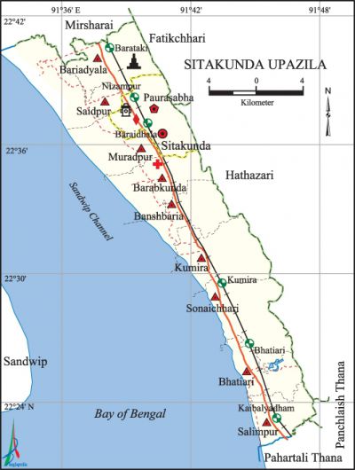
Sitakunda Upazila
Sitakunda Upazila (chittagong district) area 483.96 sq km, located in between 22°22' and 22°42' north latitudes and in between 91°34' and 91°48' east longitudes. It is bounded by mirsharai and fatikchhari upazilas on the north, pahartali thana on the south, Fatikchhari, hathazari upazilas and panchlaish thana on the east, sandwip upazila and Sandwip channel on the west.
Population Total 387832; male 202137, female 185695; Muslim 334053, Hindu 51797, Buddhist 1345, Christian 229 and others 408.
Water bodies bay of bengal; Sandwip Channel is notable.
'Administration Sitakunda Thana was formed in 1979 and it was turned into an upazila in 1983.
| Upazila | ||||||||
| Municipality | Union | Mouza | Village | Population | Density (per sq km) | Literacy rate (%) | ||
| Urban | Rural | Urban | Rural | |||||
| 1 | 9 | 60 | 88 | 45147 | 342685 | 801 | 62.1 | 58.8 |
| Municipality | ||||||||
|
Area (sq km) |
Ward |
Mahalla |
Population |
Density (per sq km) |
Literacy rate (%) | |||
| 27.97 | 9 | 23 | 45147 | 1614 | 62.1 | |||
| Union | ||||
| Name of union and GO code | Area (acre) | Population | Literacy rate (%) | |
| Male | Female | |||
| Kumira 47 | 8534 | 20724 | 18172 | 57.7 |
| Banshbaria 16 | 6795 | 11041 | 10809 | 52.9 |
| Barabkunda 19 | 7035 | 17096 | 16628 | 51.5 |
| Bariadyala 28 | 6738 | 13509 | 14872 | 55.5 |
| Bhatiari 38 | 4898 | 30853 | 24581 | 60.7 |
| Muradpur 57 | 5333 | 14516 | 15086 | 54.1 |
| Salimpur 66 | 4451 | 28802 | 25995 | 65.9 |
| Saidpur 95 | 7551 | 14373 | 16282 | 58.5 |
| Sonaichhari 85 | 9146 | 28464 | 20882 | 62.3 |
Source Bangladesh Population Census 2011, Bangladesh Bureau of Statistics.

Archaeological heritage and relics Chandranath Mandir, Baskunda at Sitakunda Sadar, Bara Aulia Dargah Sharif at Sonaichhari, Harmadia Jami Mosque at Kumira.
War of Liberation An encounter was held between the freedom fighters and the Pak army at Kumira of Sitakunda with heavy causality on the side of the Pak army. Besides, two freedom fighters were killed in an encounter with the Pak army at a place near the Barabkunda Chemical Bridge. On 19 April 1971 the Pak army killed 10 innocent persons of the upazila.
For details: see সীতাকুণ্ড উপজেলা, বাংলাদেশ মুক্তিযুদ্ধ জ্ঞানকোষ (Encyclopedia of Bangladesh War of Liberation), বাংলাদেশ এশিয়াটিক সোসাইটি,ঢাকা ২০২০, খণ্ড ১০।
Religious institutions Mosque 292, temple 50, tomb 8, buddhist math 3. Noted religious institutions: Sonaichhari Central Jami Mosque, Dal Chal Shah Mosque, Salimpur Jami Mosque, tomb of Bara Aulia, Kalu Shah Mazar, Fakir Hat Mazar, Pasthishala Buddhist Vihara, Sitakunda Shankar Math, Labanakhya Mandir, Chandranath Mandir.
Literacy rate and educational institutions Average literacy 59.2%; male 62.2%, female 55.9%. Educational institutions: college 6, secondary school 30, primary school 82, satellite school 10, kindergarten 21, community school 8, madrasa 14. Noted educational institutions: Sitakunda Degree College (1968), Latifa Siddiqi College (1985), Faujdarhat Cadet College (1958), Madam Bibir Hat Shahjahan High School (1905), Sitakunda Government Model High School (1913), Jafar Nagar Aparna Charan High School (1914), Teriail High School (1937), Kumira Residential High School (1938), Sitakunda Girls' High School (1945), Sitakunda Alia Madrasa (1886).
Newspapers and periodicals Weekly: Chaloman Sitakunda; monthly: Aranno, Sristi, Sitakunda Sangbad.
Cultural organisations Library 2, cinema hall 2, press club 1, playground 18.
Tourist spots Vast sea beach, coastal forestry area, Chandranath Mandir and Hill, Ecopark and Botanical Garden.
Main sources of income Agriculture 24.12%, non-agricultural labourer 4.27%, industry 2.82%, commerce 15.43%, transport and communication 4.32%, service 28.76%, construction 1.56%, religious service 0.29%, rent and remittance 6.10% and others 12.33%.
Ownership of agricultural land Landowner 35.37%, landless 64.63.
Main crops Paddy, betel leaf, ginger, turmeric, onion, rubber, vegetables.
Main fruits Mango, jackfruit, papaya, guava, coconut, betel nut, watermelon, pineapple.
Fisheries, dairies and poultries Fishery 28, dairy 4, poultry 8.
Communication facilities Pucca road 157 km, semi-pucca 74 km, mud road 301 km; railway 45 km; Rail station 6.
Extinct or nearly extinct traditional transport Palanquin, bullock cart.
Noted manufactories Rice mill, flour mill, saw mill, jute mill, textile mill, re-rolling mill, shipyard, brick field, motor car assembling factory, corrugated iron factory, cement factory, glass factory, oxygen factory, bidi factory.
Cottage industries Goldsmith, blacksmith, potteries, wood work, bamboo work.
Hats, bazars and fairs Hats and bazars are 31, fairs 3, most noted of which are Mohantar Hat, Suklal Hat, Fakir Hat, Bara Darogar Hat, Mirer Hat, Madan Hat, Banshbaria Bazar, Kumira Bazar, Shiva Chaturdashi Mela, Chaitra Sankranti Mela and Baishakhi Mela.
Main exports Watermelon, rubber, betel leaf, vegetables.
Access to electricity All the wards and unions of the upazila are under rural electrification net-work. However 81.8% of the dwelling households have access to electricity.
Sources of drinking water Tube-well 87.4%, tap 8.1% and others 4.5%.
Sanitation 81.3% of dwelling households of the upazila use sanitary latrines and 17.7% of dwelling households use non-sanitary latrines; 1.0% of households do not have latrine facilities.
Health centres Hospital 1, upazila health complex 1, infectious disease hospital 1, TB hospital 1, family planning centre 11, clinic 2, freedom fighters charitable health centre 1, veterinary treatment centre 1.
NGO activities Operationally important NGOs are brac, asa, CARE. [Shimul Kumar Chowdhury]
References Bangladesh Population Census 2001 and 2011, Bangladesh Bureau of Statistics; Cultural survey report of Sitakunda Upazila 2007.
