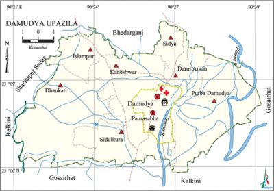
Damudya Upazila
Damudya Upazila (shariatpur district) area 90.54 sq km, located in between 23°06' and 23°10' north latitudes and in between 90°20' and 90°30' east longitudes. It is bounded by bhedarganj upazila on the north, gosairhat upazila on the south, Gosairhat upazila on the east, kalkini and shariatpur sadar upazilas on the west. Damudya is the main river port and commercial centre of the Shariatpur district.
Population Total 109003; male 51348, female 57655; Muslim 105956, Hindu 3030, Christian 2 and others 15.
Water bodies Main rivers: padma and Jayanti.
Administration Damudya Thana was formed in 1975 and it was turned into an upazila in 1982.
| Upazila | ||||||||
| Municipality | Union | Mouza | Village | Population | Density (per sq km) | Literacy rate (%) | ||
| Urban | Rural | Urban | Rural | |||||
| 1 | 7 | 58 | 120 | 17323 | 91680 | 1204 | 60.6 (2001) | 50.4 |
| Municipality | ||||||||
|
Area |
Ward |
Mahalla |
Population |
Density |
Literacy rate (%) | |||
| 7.09 (2001) | 9 | 11 | 14242 | 2125 (2001) | 64.5 | |||
| Upazila Town | ||||||||
|
Area |
Mouza |
Population |
Density |
Literacy rate (%) | ||||
| 1.19 (2001) | 1 | 3081 | 3271 (2001) | 57.1 | ||||
| Union | ||||
| Name of union and GO code | Area (acre) | Population | Literacy rate (%) | |
| Male | Female | |||
| Islampur 40 | 2157 | 4038 | 4331 | 52.7 |
| Kaneshwar 47 | 2794 | 7401 | 8383 | 60.4 |
| Darul Aman 23 | 1247 | 4403 | 5249 | 54.4 |
| Dhankati 35 | 5871 | 9876 | 10683 | 44.4 |
| Purba Damudya 59 | 4737 | 10068 | 11185 | 40.2 |
| Sidya 83 | 1227 | 3387 | 4088 | 57.4 |
| Sidulkura 71 | 3192 | 5456 | 6213 | 56.9 |
Source Bangladesh Population Census 2011, Bangladesh Bureau of Statistics.

War of Liberation Freedom fighters had a frontal encounter with the Pak army on the southern side of the present premises of Damudya College in which freedom fighters Ahsanul Hoque and Abdul Wahab were killed. Huge damages to properties were caused when the local razakars set the Damudya Bazar on fire on 15 October 1971. Memorial monuments have been built at 5 places of the upazila one of which is named after Shahid Abdul Wahab.
For details: see ডামুড্যা উপজেলা, বাংলাদেশ মুক্তিযুদ্ধ জ্ঞানকোষ (Encyclopedia of Bangladesh War of Liberation), বাংলাদেশ এশিয়াটিক সোসাইটি, ঢাকা ২০২০, খণ্ড ৪।
Religious institutions Mosque 176, temple 5, tomb 4.
Literacy rate and educational institutions Average literacy 52.5%; male 53.3%, female 51.7%. Educational Institutions: college 1, primary training institute 1, secondary school 14, primary school 59, community school 2, kindergarten 5, madrasa 111. Noted educational institutions: Damudya College, Kaneshwar SC Institutions (1913), Damudya Muslim Pilot High School (1940), Damudya Model Government Primary School (1992), Alhaj Imamuddin High School.
Cultural organisations Library 4, club 10, community centre 1, music academy 1, cinema hall 1, auditorium 1, women's organisation 1, playground 2.
Main sources of income Agriculture 54.40%, non-agricultural labourer 3.01%, industry' 1%, commerce 16.02%, transport and communication 2.41%, service 8.68%, construction 1.93%, religious service 0.31%, rent and remittance 3.79% and others 8.45%.
Ownership of agricultural land Landowner 64.59%, landless 35.41%; agricultural landowner: urban 38.12% and rural 69.79%.
Main crops Paddy, jute, masur pulse, mustard, wheat.
Extinct or nearly extinct crops Sugarcane.
Main fruits Mango, Jackfruit, plum.
Fisheries, dairies and poultries Fishery 21, dairy 8 and poultry 25.
Communication facilities Pucca road 38 km, semi-pucca road 6 km, mud road 229 km; waterway 72 km.
Extinct or nearly extinct traditional transport Palanquin.
Noted manufactories Rice mill, ice cream factory.
Cottage industries Goldsmith, blacksmith, potteries, embroidery.
Hats, bazars and fairs Hats and bazars are 7, fairs 4, most noted of which are Damudya Bazar, Kailara Bazar.
Main exports Jute, paddy, potteries.
Access to electricity All the wards and unions of the upazila are under rural electrification net-work. However 42.4% of the dwelling households have access to electricity.
Sources of drinking water Tube-well 95.7%, tap 0.6% and others 3.7 %. The presence of intolerable level of arsenic has been detected in shallow tube-well water of the upazila.
Sanitation 91.1% of dwelling households of the upazila use sanitary latrines and 6.8% of dwelling households use non-sanitary latrines; 2.1% of households do not have latrine facilities.
Health centres Upazila health complex 1, union health and family welfare centre 6, community clinic 2, veterinary hospital 1.
NGO activities Operationally important NGOs are brac, heed. [AKM Matiur Rahman]
References Bangladesh Population Census 2001 and 2011, Bangladesh Bureau of Statistics; Cultural Survey report of Damudya upazila 2010.
