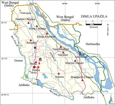
Dimla Upazila
Dimla Upazila (nilphamari district) area 326.74 sq km, located in between 26°05' and 26°17' north latitudes and in between 88°52' and 89°06' east longitudes. It is bounded by west bengal of India on the north, jaldhaka upazila on the south, hatibandha upazila on the east and domar upazila on the west.
Population Total 283438; male 142412, female 141026; Muslim 251877, Hindu 31432, Buddhist 1, Christian 27 and others 101.
Water bodies Main rivers: Buri Tista, tista, Naotara.
Administration Dimla Thana was formed in 1857 and it was turned into an upazila on 1 July 1983.'
| Upazila | ||||||||
| Municipality | Union | Mouza | Village | Population | Density (per sq km) | Literacy rate (%) | ||
| Urban | Rural | Urban | Rural | |||||
| - | 10 | 53 | 53 | 19719 | 263719 | 867 | 55.4 | 41.2 |
| Upazila Town | ||||||||
|
Area (sq km) |
Mouza |
Population |
Density (per sq km) |
Literacy rate (%) | ||||
| 16.14 | 3 | 19719 | 1222 | 55.4 | ||||
| Union | ||||
| Name of union and GO code | Area (acre) | Population | Literacy rate (%) | |
| Male | Female | |||
| Khoga Kharibari 57 | 5810 | 10767 | 10707 | 47.2 |
| Khalisa Chapani 47 | 10446 | 16994 | 16715 | 42.0 |
| Gayabari 28 | 5227 | 11575 | 11574 | 41.4 |
| Jhunagachh Chapani 38 | 11199 | 17277 | 17399 | 38.3 |
| Tepa Kharibari 95 | 7836 | 9271 | 9013 | 34.0 |
| Dimla 19 | 10619 | 22914 | 22660 | 49.0 |
| Naotara 66 | 8707 | 18028 | 17768 | 36.7 |
| Paschim Chhatnai 76 | 6702 | 11527 | 11287 | 43.9 |
| Purba Chhatnai 85 | 4472 | 7158 | 7324 | 42.9 |
| Balapara 13 | 9722 | 16901 | 16579 | 43.1 |
Source Bangladesh Population Census 2011, Bangladesh Bureau of Statistics.

Archaeological heritage and relics Dimla Rajbari, Dimla Shiva Mandir.
Historical events During the Tebhaga Movement (1946-47) Tatvanarayan Barman, leader of the movement, was killed in an encounter at the Khamar Bari (farm house) of the local feudal lord Moshiur Rahman Jadu Mia. During the language movement in 1952 Jamshed Ali Chati was arrested for his alleged involvement in the Language Movement and was sent to the Rajshahi Jail. ‘Tatvanarayan Smritistambha’ memorial monument was built at Dimla Bazar in memory of Tatvanarayan of Tebhaga Movement.
War of Liberation During the war of liberation in 1971 encounters between the freedom fighters and the Pak army were held at Shathibari, Thakurganj, Khoga and Paschim Kharibari. There are 4 Mass graves in the upazila; a memorial monument titled Smriti Amlan has been established at Dimla Sadar.
For details: see Asiatic Society of Bangladesh, বাংলাদেশ মুক্তিযুদ্ধ জ্ঞানকোষ (Encyclopedia of Bangladesh War of Liberation, Bangla Version, Vol. 4), Dimla upazila.
Religious institutions Mosque 371, temple 25.
Literacy rate and educational institutions Average literacy 42.2%; male 44.7%, female 39.7%. Educational institutions: college 6, technical college 3, secondary school 48, primary school 352, adult education centre 16, madrasa 102. Noted educational institutions: Dimla Islami Degree College (1983), Dimla Mahila College (1998), Khoga Kharibari High School (1906), Khoga Kharibari Girls' High School (1907), Naotara Abeunnechha High School (1911), Dimla Rani Brindarani Government High School (1917), Hazi Zahartullah High School (1972), Dimla Government Girls' School (1973), Dimla Nijpara Fazil Madrasa (1962).
Cultural organisations Cinema hall 2, theatre group 2, music academy 5, literary society 1, women's organisation 1.
Main sources of income Agriculture 75.36%, non-agricultural labourer 4.92%, industry 0.21%, commerce 8.27%, transport & communication 1.51%, service 3.05%, construction 0.46%, religious service 0.21%, rent & remittance 0.08% and others 5.93%.
Ownership of agricultural land Landowner 57.37%, landless 42.63%; agricultural landowner: urban 49.74% and rural 57.97%.
Main crops Paddy, wheat, corn, potato, tobacco, onion, chilli, vegetables.
Extinct or nearly extinct crops Kaun, sesame, jute.
Main fruits Mango, black berry, jackfruit, guava.
Fisheries, dairies and poultries Dairy 34, poultry 17; besides, there are fish cultivation in 3146 ponds and in a canal of the upazila.
Communication facilities Pucca road 139.00 km, semi-pucca road 10.00 km, mud road 656.12 km; waterway 40.15 km.
Extinct or nearly extinct traditional transport Palanquin, bullock cart.
Noted manufactories Saw mill, rice mill, flour mill, bidi factory.
Cottage industries Blacksmith, potteries, weaving, bamboo work, wood work, tailoring.
Hats, bazars and fairs Hats and bazars are 23, most noted of which are Dimla Babur Hat, Shathibari Hat, Thakurganj Hat, Dangar Hat and Shalhatir Hat.
Main exports Paddy, tobacco, chilli, onion.
Access to electricity All the unions of the upazila are under rural electrification net-work. However 24.9% of the dwellings have access to electricity.
Natural resources Stone, sand.
Sources of drinking water Tube-well 96.0%, tap 0.2% and others 3.8%.
Sanitation 27.7% of dwelling households of the upazila use sanitary latrines and 60.5% of dwelling households use non-sanitary latrines; 11.8% of households do not have latrine facilities.
Health centres Upazila health centre 1, satellite clinic 2, family planning centre 10, leprosy treatment centre 1, clinic 1.
NGO activities brac, asa, CARE, Ahsania Mission, RDRS. [Abdus Sattar]
References Bangladesh Population Census 2001 and 2011, Bangladesh Bureau of Statistics; Cultural survey report of Dimla Upazila 2007.'
