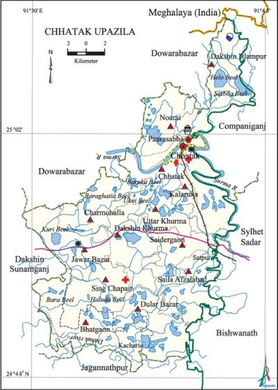
Chhatak Upazila
Chhatak Upazila (sunamganj district) area 434.76 sq km, located in between 24°49' and 25°06' north latitudes and in between 91°27' and 91°49' east longitudes. It is bounded by Meghalaya state of India and companiganj (sylhet) upazila on the north, jagannathpur on the south, Companiganj (Sylhet), sylhet sadar and bishwanath upazilas on the east, dakshin sunamganj and dowarabazar upazilas on the west.
Population Total 334546; male 171761, female 162785; Muslim 313971, Hindu 20238, Buddhist 74, Christian 17 and others 246.
Water bodies Main river: surma; Helu, Haluda, Kuri, Baruka and Satbila beels are notable.
Administration Chhatak Thana, now an upazila, was formed in 1908.
| Upazila | ||||||||
| Municipality | Union | Mouza | Village | Population | Density (per sq km) | Literacy rate (%) | ||
| Urban | Rural | Urban | Rural | |||||
|
1 |
13 |
311 |
524 |
38670 |
295876 |
766 |
54.2 |
33.8 |
| Municipality | ||||||||
|
Area |
Ward |
Mahalla |
Population |
Density |
Literacy rate | |||
|
11.80 |
9 |
22 |
34172 |
2896 |
55.90 | |||
| Upazila Town | ||||||||
|
Area |
Mouza |
Population |
Density |
Literacy rate | ||||
|
5.58 |
4 |
4498 |
806 |
39.60 | ||||
| Union | ||||
| Name of union and GO code | Area (acre) | Population | Literacy rate (%) | |
| Male | Female | |||
|
Uttar Khurma 94 |
6594 |
7465 |
7608 |
32.17 |
|
Kalaruka 57 |
8873 |
14800 |
14203 |
30.24 |
|
Charmohalla 14 |
8057 |
9740 |
9464 |
27.96 |
|
Chhatak 13 |
4963 |
4931 |
4833 |
25.57 |
|
Jawar Bazar 52 |
9091 |
14395 |
13083 |
31.87 |
|
Dakshin Islampur 47 |
9536 |
13116 |
12175 |
31.00 |
|
Dakshin Khurma 42 |
8117 |
9450 |
9163 |
39.55 |
|
Dular Bazar 38 |
9932 |
16597 |
15553 |
42.26 |
|
Noarai 76 |
8014 |
15023 |
14580 |
20.06 |
|
Bhatgaon 11 |
11745 |
13015 |
12555 |
38.77 |
|
Sing Chapair 92 |
7655 |
10086 |
9938 |
34.30 |
|
Saila Afzalabad 90 |
8198 |
12975 |
12281 |
41.64 |
|
Saidergaon 85 |
4392 |
11939 |
11406 |
39.65 |
Source Bangladesh Population Census 2001,Bangladesh Bureau of Statistics.

Archaeological heritage and relics Bagbari Tila.
Historical events The people of Chhatak, under the leadership of Ganga Singha, revolted against the east india company in 1788. In an encounter with the soldiers of the Company, Ganga Singha was captured and later on committed suicide by jumping into the river. During the war of liberation, on 28 April 1971, a battle was fought between the freedom fighters and the Pak army in which 13 freedom fighters were killed and 11 were wounded. Besides, encounters were held between the freedom fighters and the Pak army at Hader Tila and Durbin Tila.
Marks of War of Liberation Shikha Satera (seventeen flames) at Madhavpur and Chhatak Central Memorial Monument.
Literacy rate and educational institutions Average literacy 36.3%; male 40.0%, female 32.4%. Noted educational institutions: Chhatak Degree College (1972), Gobindaganj A Haque Smriti Degree College (1974), Jaua Bazar College (1995), Chhatak Technical School and College (1981), Chandranath Girls' High School (1857), Chhatak Multilateral High School (1941), Gobindaganj High School (1957), Jalalia Alim Madrasa (1980).'
Newspapers and periodicals Periodical: Suchayan, Prattayan, Mangala (1906) (defunct); Weekly: Chhatak Kantha, Chhatak Barta (defunct); Monthly: Jhankar (1929), Pradip (1929) (defunct).
Cultural organisations Library 3, cinema hall 1, theatre group 3, others 2.
Main sources of income Agriculture 52.15%, non-agricultural labourer 10.33%, industry 0.60%, commerce 10.19%, transport and communication 1.19%, service 7.16%, construction 0.89%, religious service 0.42%, rent and remittance 3.23% and others 13.84%.
Ownership of agricultural land Landowner 46.87%, landless 53.13%; agricultural landowner: urban 33.48% and rural 48.86%.
Main crops Paddy, sesame, linseed, vegetables.
Main fruits Orange, pineapple, litchi.
Fisheries, dairies and poultries Fishery 30, dairy 37, poultry 130, nursery 7.
Communication facilities Pucca road 173.92 km, mud road 305.90 km; railway 34 km; waterway 1.70 nautical miles.
Extinct or nearly extinct traditional transport Palanquin.
Manufactories Chhatak Cement Factory, Chhatak Pulp and Paper Mill, Concrete and Slipper Plant and lime industry Chhatak Cement Company (1941), Lafarse Surma Cement Company (2000), Nitol Pump and Paper Mill and Pre States Concrete Slipper Co. are notable.'
Cottage industries Weaving, cane and bamboo work, crafts made of reed and chhan (a kind of tall grass). '
Hats, bazars and fairs Hats and bazars are 28, most noted of which are Chhatak Bazar, Gobindaganj Bazar, Jaua Bazar, Dular Bazar; Manipuri Rush Purnima Mela and Durbin Shah Mela.
Main exports Orange, natural gas, cement, lime stone, paper and paper pulp.
Access to electricity All the wards and unions of the upazila are under rural electrification net-work. However 18.82% of the dwelling households have access to electricity.
Natural resources Lime, limestone, sand, gas, bamboo and cane.
Sources of drinking water Tube-well 56.88%, pond 23.95%, tap 3.98% and others 15.19%. The presence of arsenic has been discovered in 23.5% of the shallow tube-well water in the Paurasabha area and 12.26% of the shallow tube well water in the union areas.
Sanitation 36.05% (rural 32.40% and urban 60.65%) of dwelling households of the upazila use sanitary latrines and 48.71% (rural 51.02% and urban 33.13%) of dwelling households use non-sanitary latrines; 15.24% of households do not have latrine facilities.
Health centres Upazila health centre 1, union health and family planning centre 10, community clinic 12.
NGO activities Operationally important NGOs are brac, CARE. [Ashfaq Hossain]
References Bangladesh Population Census 2001, Bangladesh Bureau of Statistics; Cultural survey report of Chhatak Upazila 2007.
