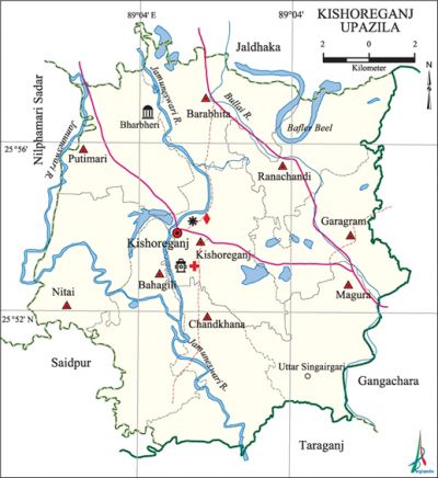
Kishoreganj Upazila (Nilphamari)
Kishoreganj Upazila (nilphamari district) area 204.90 sq km, located in between 25°49' and 25°59' north latitudes and in between 88°57' and 89°07' east longitudes. It is bounded by jaldhaka upazila on the north, taraganj upazila on the south, gangachara upazila on the east, nilphamari sadar and saidpur upazilas on the west.
Population Total 253192; male 130781, female 122411; Muslim 213285, Hindu 39411, Buddhist 57 and others 439.
Water bodies Main rivers: Jamuneswari, Bullai; Baflar Beel are notable.
Administration Kishoreganj Thana, now an upazila, was formed in 1921.
| Upazila | ||||||||
| Municipality | Union | Mouza | Village | Population | Density (per sq km) | Literacy rate (%) | ||
| Urban | Rural | Urban | Rural | |||||
|
- |
9 |
51 |
53 |
8326 |
244866 |
1236 |
42.1 |
32.4 |
| Upazila Town | ||||||||
|
Area (sq km) |
Mouza |
Population |
Density |
Literacy rate | ||||
|
4.46 |
2 |
8326 |
1867 |
42.1 | ||||
| Union | ||||
| Name of union and GO code | Area (acre) | Population | Literacy rate (%) | |
| Male | Female | |||
|
Kishoreganj 51 |
5659 |
18241 |
16926 |
33.64 |
|
Barabhita 25 |
5533 |
11775 |
11114 |
34.93 |
|
Bahagili 17 |
5699 |
11874 |
11416 |
30.65 |
|
Putimari 86 |
5913 |
16231 |
14867 |
31.81 |
|
Nitai 69 |
5283 |
13025 |
12308 |
29.19 |
|
Chandkhana 34 |
5700 |
13700 |
12442 |
30.47 |
|
Ranachandi 94 |
5690 |
13249 |
12652 |
32.28 |
|
Garagram 43 |
5679 |
14397 |
13615 |
38.62 |
|
Magura 60 |
5483 |
18289 |
17071 |
32.22 |
Source Bangladesh Population Census 2001, Bangladesh Bureau of Statistics.
Archaeological heritage and relics Three domed Mosque of Chand Khosal (Bherberi, eighteenth century), Putimari Mandir (Putimari), Nabagayadham (Bahagili), furnace of the mother of Bhim (Kishoreganj sadar).
History of the War of Liberation In May 1971 the Pak army, in collaboration with the local razakars captured Rabindranath Kundu (noted businessman) and killed him after 8 days. In the same way the Pak army also killed Mustafizur Rahman on 11 December. On 14 December a battle was fought between the joint forces (freedom fighters and the allied forces) and the Pak army in which two freedom fighters were killed.

Religious institutions Mosque 380, temple 99, tomb 2.
Literacy rate and educational institutions Average literacy 32.7%; male 38.3%, female 26.8%. Educational institutions: college 10, secondary school 42, primary school 159, madrasa 30. Noted educational institutions: Kishoreganj Degree College (1972), Magura Multilateral High School (1926), Kishoreganj Multilateral High School (1939), Sharifabad Biltilateral School.
Cultural organisations Library 2, club 22, cinema hall 2, theatre group 1, theatre stage 1, playground 27.
Main sources of income Agriculture 76.46%, non-agricultural labourer 3.62%, industry 0.40%, commerce 9.87%, transport and communication 1.76%, service 3.30%, construction 0.37%, religious service 0.29%, rent and remittance 0.03% and others 3.90%.
Ownership of agricultural land Landowner 56.41%, landless 43.59%; agricultural landowner: urban 43.94% and rural 56.81%.
Main crops Paddy, potato, tobacco, ginger, vegetables.
Extinct or nearly extinct crops Linseed, sesame, arahar, mustard.
Main fruits Mango, jackfruit, banana, litchi, papaya.
Communication facilities Pucca road 91.60 km, mud road 344.71 km.
Extinct or nearly extinct traditional transport Palanquin, horse carriage, bullock cart.
Noted manufactories Ice factory, welding factory.
Cottage industries bamboo work, wood work, blacksmith, tailoring are notable. Besides, cocoons are produced in the upazila by women labour.
Hats, bazars and fairs Hats and bazars are 23, fairs 1, Kishoreganj Hat, Tepa Hat, Baravita Hat, Magura Hat, Garagram Hats and Tatuar Mela.
Main exports Paddy, potato, ginger, vegetables.
Access to electricity All the unions of the upazila are under rural electrification net-work. However 8.49% of the dwelling households have access to electricity.
Sources of drinking water Tube-well 85.45%, tap 0.28%, pond 0.53% and others 13.74%.
Sanitation 5.66% (rural 4.75% and urban 34.12%) of dwelling households of the upazila use sanitary latrines and 20.86% (rural 21.25% and urban 8.71%) of dwelling households use non-sanitary latrines; 73.48% of households do not have latrine facilities.
Health centres Upazila health complex 1, family planning centre 8, satellite clinic 2.
NGO activities Operationally important NGOs are brac, asa, CARE. [Md. Azizul Islam Promanik]
References Bangladesh Population Census 2001, Bangladesh Bureau of Statistics; Cultural survey report of Kishoreganj Upazila 2007.
