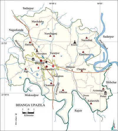
Bhanga Upazila
Bhanga Upazila (faridpur district) area 216.34 sq km, located in between 23°17' and 23°28' north latitudes and in between 89°55' and 90°06' east longitudes. It is bounded by sadarpur and nagarkanda upazilas on the north, muksudpur and rajoir upazilas on the south, shibchar and Sadarpur upazilas on the east, Nagarkanda and Muksudpur upazilas on the west.
Population Total 232386; male 117248, female 115138; Muslim 213390, Hindu 18963, Christian 11 and others 22.
Water bodies Main rivers: arial khan, kumar, shitalakshya.
Administration Bhanga Thana was formed in 1908 and it was turned into an upazila in 1983.
| Upazila | ||||||||
| Municipality | Union | Mouza | Village | Population | Density (per sq km) | Literacy rate (%) | ||
| Urban | Rural | Urban | Rural | |||||
|
1 |
12 |
136 |
205 |
39743 |
192643 |
1074 |
46.8 |
36.3 |
| Municipality | ||||||||
|
Area |
Ward |
Mahalla |
Population |
Density |
Literacy rate (%) | |||
|
18.30 |
9 |
26 |
28057 |
1533 |
51.6 | |||
| Upazila Town | ||||||||
|
Area |
Mouza |
Population |
Density |
Literacy rate (%) | ||||
|
17.03 |
2
|
11686 |
686 |
35.0 | ||||
| Union | ||||
| Name of union and GO code | Area (acre) | Population | Literacy rate (%) | |
| Male | Female | |||
|
Azimnagar 15 |
3996 |
7693 |
7821 |
35.68 |
|
Algi 13 |
7051 |
13957 |
13221 |
31.81 |
|
Kaolibera 63 |
5149 |
9317 |
9477 |
35.51 |
|
Kalamrida 55 |
3782 |
7749 |
7748 |
36.48 |
|
Gharua 39 |
6186 |
11929 |
11806 |
32.86 |
|
Chandra 31 |
2896 |
6657 |
6751 |
33.28 |
|
Chumordi 25 |
4484 |
4780 |
4800 |
41.36 |
|
Tuzarpur 94 |
3575 |
6590 |
6535 |
32.75 |
|
Nasirabad 79 |
3226 |
6547 |
6984 |
41.88 |
|
Nurullaganj 87 |
4600 |
8947 |
8643 |
35.87 |
|
Manikdaha 71 |
4564 |
9372 |
9231 |
38.66 |
|
Hamirdi 47 |
3954 |
9016 |
8758 |
43.93 |
Source Bangladesh Population Census 2001, Bangladesh Bureau of Statistics.

Archaeological heritage and relics Pathrail Mosque (1493-1519), Pathrail Dighi (tank), Mazar of Majlish Abdullah Khan, Roynagar Mosque (built in Mughal period), Basudeva Mandir at Khatra, Siddeswari Theatre Stage at Bhanga.
Marks of the War of Liberation Mass grave 1 (Noapara).
Religious institutions Mosque 384, temple 39, sacred place 1 (Khatra). Noted religious institutions: Patrail Mosque, Roynagar Mosque, Gharua Jami Mosque, Bhanga Bazar Jami Mosque, Basudeva Temple.
Literacy rate and educational institutions Average literacy 38.1%; Male 42.6%, female 33.6%. Educational institutions: college 5, secondary school 20, primary school 73, madrasa 10, orphanage 3. Noted educational institutions: Bhanga Pilot High School (1889), Sadardi High School (1917), Kalamridha Gobinda High School (1927).
Newspapers and periodicals Weekly: Bhanga Khabar.
Cultural organisations Library 3, club 2, cinema hall 1, women's organisation 1, theatre group 1, Shilpakala Academy 1.
Main sources of income Agriculture 55.51%, non-agricultural labourer 2.79%, industry 1.36%, commerce 20.32%, transport and communication 2.77%, service 6.12%, construction 1.22%, religious service' 0.22%, rent and remittance 2.50% and others 7.19%.
Ownership of agricultural land Landowner 58.66%, landless 41.34%; agricultural landowner: urban' 48.36% and rural 60.75%.
Main crops Paddy, wheat, jute, onion, mustard, vegetables.
Extinct or nearly extinct crops Sesame, linseed, kaun.
Main fruits Mango, black berry, jackfruit, litchi, banana, palm, papaya, safeda, coconut.
Fisheries, dairies and poultries Fishery 245, Dairy 60, poultry 64.
Communication facilities Pucca road 100 km, mud road 400 km; waterways 22 nautical miles.
Extinct or nearly extinct traditional transport Palanquin, bullock cart.
Noted manufactories Rice mill, flour mill, oil mill, ice mill, fertiliser factory, biscuit factory.
Cottage industries Goldsmith, blacksmith, weaving, potteries, umbrella industry, bamboo work, cane work.
Hats, bazars and fairs Hats and bazars are 45, fairs 4, most noted of which are Bhanga, Deora, Chowkighata, Maligram, Kaolibera, Mansurabad, Gharua and Pukuria Hat and Mukdoba Mela, Bhanga Chaitra Sankranti Mela and Khatra Mela.
Main exports Paddy, wheat, palm molasses, onion seed, vegetables, coconut, safeda.
Access to electricity All the wards and unions of this upazila are under rural electrification net-work. However 18.62% (rural 54.10% and urban 15.47%) of the dwelling households have access to electricity.
Sources of drinking water Tube-well 95.03%, tap 0.31%, pond 1.06% and others 3.59.
Sanitation 41.78% (rural 56.65% and urban 38.76%) of dwelling households of the upazila use sanitary latrines and 51.78% (rural 37.72% and urban 54.63%) of dwelling households use non-sanitary latrines; 6.44% (rural 5.63% and urban 6.60%) of households do not have latrine facilities.
Heath centres Upazila health complex 1, union health centre 3, family welfare centre 8, satellite clinic 2, community clinic 27, clinic 4.
NGO activities brac, proshika, asa, SEDP. [Profulla Kumar Nandi]
References Bangladesh Population Census 2001, Bangladesh Bureau of Statistics; Cultural survey report of Bhanga Upazila 2007.
