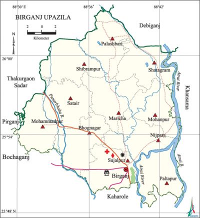
Birganj Upazila
Birganj Upazila (dinajpur district) area 413 sq km, located in between 25°48' and 26°04' north latitudes and in between 88°29' and 88°44' east longitudes. It is bounded by thakurgaon sadar and debiganj upazilas on the north, kaharole upazila on the south, Atrai river and khansama upazila on the east, bochaganj, pirganj (rangpur), Thakurgaon Sadar upazilas on the west.
Population Total 269893; male 138269, female 131624; Muslim 186772, Hindu 76583, Buddhist 3023, Christian 121 and others 3394.
Water bodies Main rivers: atrai, punarbhaba; Paisa, Lal and Chandraghorer beels are notable.
Administration Birganj Thana was formed in 1890 and it was turned into an upazila in 1983. '
| Upazila | ||||||||
| Municipality | Union | Mouza | Village | Population | Density (per sq km) | Literacy rate (%) | ||
| Urban | Rural | Urban | Rural | |||||
|
- |
11 |
186 |
186 |
13591 |
256302 |
653 |
58 |
37.7 |
| Upazila Town | ||||||||
|
Area |
Mouza |
Population |
Density |
Literacy rate | ||||
|
6.5 |
2 |
13591 |
2091 |
58 | ||||
| Union | ||||
| Name of union and GO code | Area (acre) | Population | Literacy rate (%) | |
| Male | Female | |||
|
Nijpara 43 |
9487 |
13340 |
12654 |
44.59 |
|
Palashbari 51 |
9239 |
12077 |
11268 |
37.42 |
|
Paltapur 60 |
9550 |
12591 |
12088 |
35.07 |
|
Bhognagar 08 |
9537 |
12078 |
11404 |
39.13 |
|
Maricha 17 |
9401 |
11773 |
11297 |
40.19 |
|
Mohanpur 34 |
8823 |
12684 |
12065 |
38.65 |
|
Mohammadpur 25 |
7915 |
9101 |
8990 |
41.39 |
|
Shatagram 69 |
9259 |
12349 |
11905 |
35.05 |
|
Shibrampur 86 |
9541 |
12761 |
12236 |
32.89 |
|
Satair 77 |
9715 |
12020 |
11356 |
33.43 |
|
Sujalpur 94 |
9586 |
17495 |
16361 |
46.11 |
Source Bangladesh Population Census 2001, Bangladesh Bureau of Statistics.

Archaeological heritage and relics Sengram Jami Mosque, Laskarpur Jami Mosque.
Historical events This upazila was one of the major centres of the tebhaga movement and santal rebellion. In the first week of December 1971 an encounter was held between the freedom fighters and the Pak army at a place on the eastern side of Bhatgaon Bridge in which about 50 Pak soldiers were killed; the freedom fighters also destroyed two military tanks of the Pak army. In this encounter a number of freedom fighters were also killed.
Religious institutions Mosque 312, temple 45, church 5, tomb 2.
Literacy rate and educational institutions Average literacy 38.8%; male 45.6%, female 31.8%. Educational institutions: college 8, secondary school 73, primary school 210, kindergarten 8, madrasa 26. Noted educational institutions: Birganj Degree College, Birganj Mahila College, Gopalganj College, Birganj Technical College, Chowdhuri Hat Technical College, Palashbari USC High School (1942), Rahimbox High School (1944), Jharbari High School (1957), Birganj Government High School (1962), Gopalganj High School (1969).
Newspapers and periodicals Chetona, Shalban.
Cultural organisations Library 11, women's organisation 12, theatre group 1, opera party 2, cinema hall 2.
Amusement centres Singara Shalban.
Main sources of income Agriculture 74.04%, non-agricultural labourer 3.71%, industry 0.67%, commerce 9.81%, transport and communication 2.61%, service 3.38%, construction 0.69%, religious service 0.13%, rent and remittance 0.14% and others 4.82%.
Ownership of agricultural land Landowner 50.21%, landless 49.79%; agricultural landowner: urban 41.17% and rural 50.66%.
Main crops Paddy, wheat, sugarcane, potato.
Extinct or nearly extinct crops Jute, sesame, kaun.
Main fruits Watermelon, mango, banana, jackfruit, litchi.
Fisheries, dairies and poultries Fishery 12, poultry 15.
Communication facilities Pucca road 86 km, mud road 785 km.
Extinct or nearly extinct traditional transport Palanquin, bullock cart and horse carriage.
Noted manufactories Automatic rice mill, husking mill, saw mill, oil mill, chira (threshed rice) mill, ice factory, biscuit factory.
Cottage industries Goldsmith, blacksmith, potteries, wood work.
Hats, bazars and fairs Hats and bazars are 50, fairs 6, most noted of which are Gopalganj Hat and Dhemdhemedia Kali Mela.
Main exports Watermelon, litchi, potato.
Access to electricity All the unions of the upazila are under rural electrification net-work. However 16.31% of the dwelling households have access to electricity.
Sources of drinking water Tube-well 91.37%, pond 0.22%, tap 0.17% and others 8.24%.
Sanitation 14.62% (rural 12.22% and urban 63%) of dwelling households of the upazila use sanitary latrines and 23.36% (rural 23.95% and urban 11.58%) of dwelling households use non-sanitary latrines; 62.02% of households do not have latrine facilities.
Health centres Upazila health complex 1, union health and family planning centre 10, health centre 2, clinic 1, pathology lab 1.
NGO activities Operationally important NGOs are brac, asa, caritas. [Mamtajur Alam Ilu]
References Bangladesh Population Census 2001, Bangladesh Bureau of Statistics; Cultural survey report of Birganj Upazila 2007.
