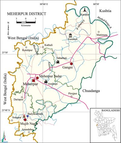
Meherpur District
Meherpur District (khulna division) area 751.62 sq km, located in between 23°36' and 23°58' north latitudes and in between 88°33'and 88°53' east longitudes. It is bounded by kushtia district and west bengal state of India on the north, chuadanga district and West Bengal state of India on the south, Chuadanga and Kushtia districts on the east, West Bengal state of India on the west.
Population Total 655392; male 324634, female 330758; Muslim 640751, Hindu 7870, Buddhist 14, Christian 6627 and others 130.
Water bodies Main rivers: bhairab, ichamati, Mathabhaga, Kazla.
| District | |||||||||
| Area (sq km) | Upazila | Municipality | Union | Mouza | Village | Population | Density (per sq km) | Literacy rate (%) | |
| Urban | Rural | ||||||||
| 751.62 | 3 | 2 | 18 | 183 | 274 | 83393 | 571999 | 872 | 46.3 |
| Others Information of District | ||||||||
|
Name of Upazila |
Area |
Municipality |
Union |
Mouza |
Village |
Population |
Density |
Literacy rate |
| gangni | 363.95 | 1 | 9 | 90 | 137 | 299607 | 823 | 42.2 |
| mujibnagar | 111.51 | - | 4 | 29 | 33 | 99143 | 889 | 50.5 |
| meherpur sadar | 276.15 | 1 | 5 | 61 | 104 | 256642 | 929 | 49.4 |
Source Bangladesh Population Census 2011, Bangladesh Bureau of Statistics.

Administration During the British rule in India Meherpur was under Nadia district. Meherpur Town was established in early sixteenth century. Meherpur Municipality was formed in 1960. Meherpur district was formed on 24 February 1984.
War of Liberation On 30 and 31 March 1971 the Pak army equipped with most modern arms and ammunitions was miserably defeated in a battle with the Ansar Mujahid and general people of Gangni upazila. On 17 April 1971 Professor mohammad yusuf ali read out the proclamation of independence at Mujibnagar (former name Bhaberpara, Badhayanathtola). The first provisional government of Bangladesh took oath on the same day. On 18 April 1971 the Pak army killed 8 innocent persons at Amjhupi of Meherpur Town. There is a mass killing site on the backyard of Meherpur College and mass grave at Kazipur and Tepukhali. A memorial complex covering 20.10 acres (8.13 ha) has been built at the site where the ministers of the first government took their oaths.
Literacy rate and educational institutions Average literacy 46.3%; male 46.9%, female 45.7%. Educational institutions: college 7, vocational institute 3, secondary school 60, primary school 200, madrasa 11. Noted educational institutions: Meherpur Government College (1962), Mujibnagar Degree College (1983), Gangni Degree College (1983), Meherpur Government Mohila College (1984), Gangni Mohila College (1995), Meherpur Government Boys' High School (1854), Meherpur Model High School (1859), Mujibnagar Secondary School (1937), Meherpur Government Girls' School (1940), Gangni Secondary School (1945).
Main sources of income Agriculture 68.95%, non-agricultural labourer 3.24%, industry 0.87%, commerce 13.83%, transport and communication 2.21%, service 3.81%, construction 1.03%, religious service 0.14%, rent and remittance 0.59% and others 5.33%.
Newspapers and periodicals Daily: Azam; weekly: Parichay (1985), Chumbak (1986); fortnightly: Pashimanchal; monthly: Sadhak (1913), Palli Shree (1935), Simanta (1962), Probaha (1979); periodical: Basumati, Nandankanan; bulletin:' Raktashaskhar (irregular), Agami (irregular); defunct: weekly Mujibnagar (1988), weekly Meherpur (1992).
Folk culture Notable folk culture of the district include Baul song, Dehatatva song, Shashra song, Pala song, Kabi song, riddle, proverbs, etc.
Important installations Mujibnagar Memorial Monument and Complex. [Md. Abu Hasan Farooque]
See also The upazilas under this district.
References Bangladesh Population Census 2001 and 2011, Bangladesh Bureau of Statistics; Cultural survey report of Meherpur District 2007; Cultural survey report of Upazilas of Meherpur District 2007.
