Lakhai Upazila
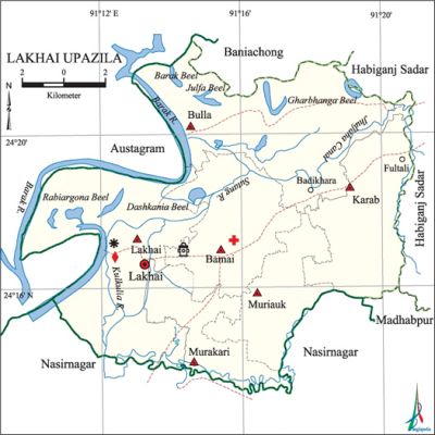
Lakhai Upazila (habiganj district) area 196.56 sq km, located in between 24°13' and 24°23' north latitudes and in between 91°10' and 91°21' east longitudes. It is bounded by austagram and baniachang upazilas on the north, nasirnagar upazila on the south, habiganj sadar, madhabpur and Nasirnagar upazilas on the east, Austagram upazila on the west.
Population Total 120677; male 59021, female 61656; Muslim 101575, Hindu 19033 and others 69.
Water bodies Main rivers: barak, Kulkulia, Sutang; Gharbhanga, Julfa, Barak, Robiargona and Dashkania beels and Jhuljaha Canal are notable.
Administration Lakhai Thana, now an upazila, was formed in 1922.
| Upazila | ||||||||
| Municipality | Union | Mouza | Village | Population | Density (per sq km) | Literacy rate (%) | ||
| Urban | Rural | Urban | Rural | |||||
|
-
|
6
|
70
|
63
|
14296
|
106381
|
614
|
29.91
|
33.61 |
| Upazila Town | ||||||||
|
Area (sq km)
|
Mouza
|
Population
|
Density (per sq km)
|
Literacy rate (%)
| ||||
|
14.62
|
2
|
14296
|
977
|
26.16 | ||||
| Union | ||||
| Name of union and GO code | Area (acre) | Population | Literacy rate (%) | |
| Male | Female | |||
|
Karab 40
|
6942
|
9169
|
8811
|
28.67
|
|
Bamai 13
|
7113
|
10698
|
11146
|
28.21
|
|
Bulla 27
|
12168
|
9520
|
9236
|
35.41
|
|
Murakari 67
|
4260
|
9487
|
10647
|
25.16
|
|
Muriauk 81
|
4704
|
8740
|
10665
|
30.48
|
|
Lakhai 54
|
11825
|
11407
|
11151
|
25.26 |
Source Bangladesh Population Census 2001, Bangladesh Bureau of Statistics.

Religious institutions Mosque 110, temple 5, tomb 5, sacred place 2.
Literacy rate and educational institutions Average literacy 28.75%; male 32.79%, female 25.04%. Educational institutions: college 1, secondary school 10, primary school 51, kindergarten 1, madrasa 17. Noted educational institutions: Lakhai ACRC High School (1945), Barishal Karab High School (1947), Bamai High School (1961), Karab Rahmania Madrasa, Jigura Tofayelia Senior Madrasa.
Cultural organisations Library 2, club 6, cultural organisation 2, auditorium 1, community centre 1,' playground 3.
Main sources of income Agriculture 67.41%, non-agricultural labourer 4.27%, commerce 13.05%, transport and communication 0.60%, service 3.24%, construction 0.43%, religious service 0.29%, rent and remittance 0.33% and others 10.38%.
Ownership of agricultural land Landowner 58.93%, landless 41.07%; agricultural landowner: urban 54.07% and rural 59.58%.
Main crops Paddy, jute, wheat.
Extinct or nearly extinct crops Sesame, linseed, kaun.
Main fruits Mango, jackfruit, papaya, coconut, black berry.
Fisheries, dairies and poultries Fishery 5, dairy 40, poultry 85.
Communication facilities Pucca road 25 km, semi-pucca road 10 km, mud road 81 km; waterway 14 nautical miles.
Extinct or nearly extinct traditional transport Palanquin, horse carriage and bullock cart.
Noted manufactories Welding factory 3.
Cottage industries Goldsmith, blacksmith, potteries, weaving, bamboo and wood work.
Hats, bazars and fairs Hats and bazars are 16, fairs 4, most noted of which are Lakhai Bazar, Bulla Bazar, Bamai cattle market, Kalibari Mela and Bulla Mela.
Main exports Paddy, jute, fish.
Access to electricity All the unions of the upazila are under rural electrification net-work. However 9.57% of the dwelling households have access to electricity.
Sources of drinking water Tube-well 89.95%, tap 1.05%, pond 4.57% and others 4.43%.
Sanitation 14.37% (rural 14.57% and urban 12.88%) of dwelling households of the upazila use sanitary latrines and 79.94% (rural 79.27% and urban 84.95%) of dwelling households use non-sanitary latrines; 5.69% of households do not have latrine facilities.
Health centres Upazila health complex 1, union health and family welfare centre 6, family planning centre 3, mother and child welfare centre 1, maternity' 1, charitable hospital 1, veterinary hospital 2.
NGO activities Operationally important NGOs are brac, asa. [Jayanta Singh Roy]
References Bangladesh Population Census 2001, Bangladesh Bureau of Statistics; Cultural survey report of Lakhai Upazila 2007.
