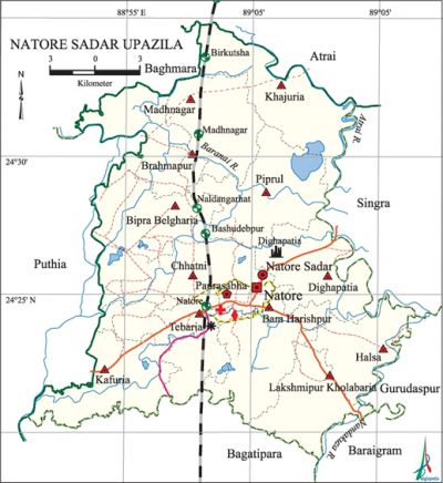
Natore Sadar Upazila
Natore Sadar Upazila (natore district) area 401.29 sq km, located in between 24°19' and 24°35' north latitudes and in between 88°51' and 89°07' east longitudes. It is bounded by atrai and baghmara upazilas on the north, bagatipara and baraigram upazilas on the south, singra and gurudaspur upazila on the east, puthia and Baghmara upazilas on the west.
Population Total 400030; male 207466, female 192564; Muslim 366587, Hindu 31650, Buddhist 904, Christian 15 and others 874. Indigenous communities such as oraon, santal and Buno belong to this upazila.
Water bodies Main rivers: atrai, Barnai, Nandakuja.
Administration Natore Thana was formed in 1793 and it was turned into an upazila in 1984. 'Natore Municipality was formed in 1869.
| Upazila | ||||||||
| Municipality | Union | Mouza | Village | Population | Density (per sq km) | Literacy rate (%) | ||
| Urban | Rural | Urban | Rural | |||||
|
1 |
12 |
263 |
302 |
87128 |
312902 |
997 |
63.6 |
40.3 |
| Municipality | ||||||||
|
Area (sq km) |
Ward |
Mahalla |
Population |
Density |
Literacy rate (%) | |||
|
14.80 |
9 |
33 |
70835 |
4786 |
67.9 | |||
| Upazila Town | ||||||||
|
Area (sq km) |
Mouza |
Population |
Density (per sq km) |
Literacy rate (%) | ||||
|
12.38 |
7 |
16293 |
1316 |
44.4 | ||||
| Union | ||||
| Name of union and GO code | Area (acre) | Population | Literacy rate (%) | |
| Male | Female | |||
|
Kafuria 51 |
7944 |
15114 |
14022 |
46.80 |
|
Khajuria 58 |
9751 |
9891 |
9360 |
44.38 |
|
Chhatni 29 |
8741 |
17227 |
15838 |
37.94 |
|
Tebaria 94 |
7829 |
15420 |
14245 |
40.36 |
|
Dighapatia 36 |
8231 |
16596 |
15508 |
42.69 |
|
Piprul 87 |
9905 |
14081 |
13081 |
38.19 |
|
Bara Harishpur 12 |
8234 |
16264 |
14921 |
39.15 |
|
Bipra Belgharia 14 |
8360 |
14620 |
13598 |
37.92 |
|
Brahmapur 21 |
7332 |
12870 |
11893 |
41.71 |
|
Madhabnagar 73 |
7752 |
11799 |
11042 |
44.56 |
|
Lakshmipur Kholabaria 65 |
6637 |
14102 |
13148 |
37.74 |
|
Halsa 43 |
5523 |
12493 |
12062 |
35.34 |
Source Bangladesh Population Census 2001, Bangladesh Bureau of Statistics.

Archaeological heritage and relics Natore Rajbari and Dighapatia Rajbari (Uttara Ganabhaban), Madanmohan Rath made of copper (Madhabnagar), Vishnu statue of gorur (prince of birds) as his mounts (Kuriapara).
Historical events indigo resistance movement was held in this district during 1859 to 1860. In 1932 a movement was launched at village Birkutsa against the zamindars in protest of increased rate of land tax. During the war of liberation a direct battle was fought between the Pak army and the freedom fighters on 29 March in which about 40 Pak soldiers were killed. On 3 June 1971, the Pak army indiscriminately killed about more than three hundred innocent people at village Chhatni.
Marks of the War of Liberation Mass grave 1.
Religious institutions Mosque 566, temple 46, church 3. Noted religious institutions: tomb of Bura Pir, Joykali Mandir.
Literacy rate and educational institutions Average literacy 45.44%; male 49.91%, female 40.64%. Educational institutions: college 17, PTI 1, technical educational institution 10, secondary school 55, primary school 162, ngo operated school 209, deaf and dumb educational institution 1, madrasa 22. Noted educational institutions: Nawab Siraj-Ud-Daulah Government College (1965), Natore Government Boys' High School (1944), Naba Bidhan Girls' High School (1967), Dighapatia PN High School (1852), Natore Maharaja Gagadindra Nath High School (1884), 'Madhnagar SI High School (1930).
Newspapers and periodicals Daily: Uttar Bangabarta, Uttarpath, Prokas, Janadesh; weekly: Natore Barta, Attikram, Uttarsuri.
Cultural organisations Library 1, club 20, cinema hall 4, theatre stage 1, theatre group 6, literary society 1, women's organisation 5.
Main sources of income Agriculture 58.68%, non-agricultural labourer 4.33%, industry 1.02%, commerce 15%, transport and communication 4.06%, service 7.99%, construction 1.22%, religious service 0.18%, rent and remittance 0.99% and others 6.53%.
Ownership of agricultural land Landowner 51.20%, landless 48.8%; agricultural landowner: urban 44.86% and rural 55.14%.'
Main crops Paddy, wheat, sugarcane, jute, ginger, turmeric, vegetables.
Extinct or nearly extinct crops Aus paddy.
Main fruits Mango, jackfruit, banana, litchi.
Fisheries, dairies and poultries Dairy 122, poultry 45, hatchery 21.
Communication facilities Pucca road 199.19 km, semi-pucca road 44.21 km, mud road 448.79 km; railway 25.25 km.
Extinct or nearly extinct traditional transport Palanquin, bullock cart, buffalo cart.
Noted manufactories Natore sugar mill.
Cottage industries Goldsmith, blacksmith, potteries.
Hats, bazars and fairs Hats and bazars are 40, fairs 29, most noted of which are Tebaria Hat, Kali Puja Mela, Madan Mahan Rath Mela.
Main exports Sugar, wheat, vegetables.
Access to electricity All the wards and unions of the upazila are under rural electrification net-work. However 31.24% of the dwelling households have access to electricity.
Sources of drinking water Tube-well 91.67%, tap 1.07%, pond 0.36% and others 6.61%.
Sanitation 35.59% (rural 26.54% and urban 70.28%) of dwelling households of the upazila use sanitary latrines and 46.15% (rural 51.88% and urban 24.17%) of dwelling households use non-sanitary latrines; 18.26% of households do not have latrine facilities.
Health centres Hospital 2, upazila health complex 1, union health centre 12, satellite clinic 4, mother and child welfare centre 1, family welfare centre 8, chest diseases hospital 1, clinic 37.
NGO activities Operationally important NGOs are brac, ITCL, CARE, thengamara mahila sabuj sangha. [Md. Rezaul Karim]
References Bangladesh Population Census 2001, Bangladesh Bureau of Statistics; Cultural survey report of Natore Upazila 2007.
