Barisal City Corporation
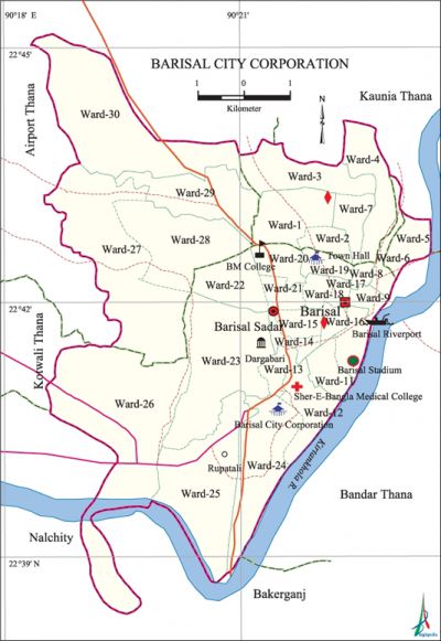
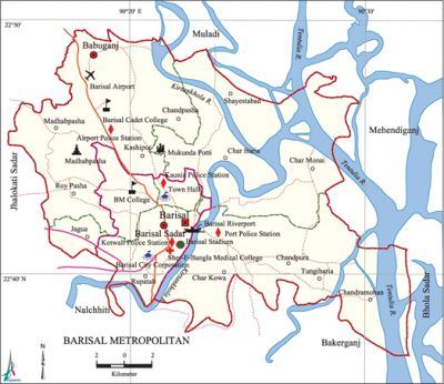
Barisal City Corporation area 24.91 sq km, located in between 22°38' and 22°45' north latitudes and in between 90°18' and 90°23' east longitudes. It is bounded by kaunia and airport thanas on the north, bandar thana and nalchity and bakerganj upazilas on the south, Kaunia and Bandar thana on the east, Airport and kotwali Model thanas and Naclcity upazila on the west.
Population Total 224389; male 123402, female 100987.
Water bodies Main River: kirtankhola.
Administration Municipality was formed in 1876 and it was turned into Barisal City Corporation on 25 July 2002.
 |
 |
| Barisal City Corporation | ||||||||
| City Corporation | Thana | Word | Mahalla | |||||
| 1 | 3 | 30 | 125 | |||||
| Thana | ||||||||
| City Corporation Thana | Area (sq km) | Ward | Mahalla | Population | Density (per sq km) | Literacy rate (%) | ||
| Male | Female | |||||||
| Airport | 3.27 | 4 | 75 | 25459 | 11215 | 77.27 | ||
| Kaunia | 4.53 | 6 | 14 | 40036 | 11341 | 68.13 | ||
| Kotwali | 17.11 | 20 | 36 | 127315 | 9023 | 77.82 | ||
Source Bangladesh Population Census 2001, Bangladesh Bureau of Statistics.
| Barisal City Corporation at a Glance | ||||||||
| Town Committee formed | 1869 | |||||||
| First Chairman of Town Committee | J. C Price (District Commissioner) | |||||||
| Municipality formed | 1876 | |||||||
| First Chairman of Municipal | Parilal Ray | |||||||
| Upgraded to City Corporation | 25 July 2002 | |||||||
| First Mayor (acting) | Ahsan Habib Kamal | |||||||
| Present Mayor | Shawkat Hossain Hiron | |||||||
| Number of holding | 40636 | |||||||
| Population | 547605 (2010) | |||||||
| Wards | 30 | |||||||
| Ward commissioners | 30 | |||||||
| Reserved Seats for woman commissioners | 10 | |||||||
| Police Station | 2 | |||||||
| Super Markets | 4 | |||||||
| Park | 2 | |||||||
| Community Centre | 4 | |||||||
| Gymnasium | 1 | |||||||
| Graveyard and Cemetery | 4 | |||||||
| Bus Terminal | 1 | |||||||
| Traffic Signal | 8 | |||||||
Source Bangladesh Population Census 2001, Bangladesh Bureau of Statistics.
[Tapan Palit]
References Bangladesh Population Census 2001, Bangladesh Bureau of Statistics; Field report' and Cultural survey report of Barisal City Corporation 2007.
