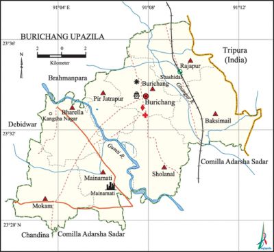
Burichng Upazila
Burichang Upazila (comilla district) area 163.76 sq km, located in between 23°28' and 23°37 north latitude and in between 91°02' and 91°13' east longitudes. It is bounded by brahmanpara upazila on the north, comilla adarsha sadar upazila on the south, tripura state of India and Comilla Adarsha Sadar upazila on the east, debidwar and chandina upazilas on the west.
Population Total 259265; male 133469, female 125796. Muslim 249213, Hindu 9981 and others 71.
Water bodies Main rivers: gumti, Ghungur, noted canals are Chandala, Nagisabila, Uttar Borakhola, Marjora and Habilar are notable.
Administration 'Burichang thana, now an upazila, was formed in 1916.
| Upazila | ||||||||
| Municipality | Union | Mouza | Village | Population | Density (per sq km) | Literacy rate (%) | ||
| Urban | Rural | Urban | Rural | |||||
|
- |
8 |
150 |
172 |
9269 |
249996 |
1583 |
61.41 |
49.31 |
| Upazila Town | ||||||||
|
Area (per sq km) |
Mouza |
Population |
Density |
Literacy (%) | ||||
|
3.73 |
1 |
9269 |
2485 |
61.41 | ||||
| Union | ||||||||
|
Name of union and GO code |
Area (acre) |
Population |
Literacy (%) | |||||
|
Male |
Female | |||||||
|
Pir Jatrapur 72 |
2768 |
10328 |
10085 |
44.95 | ||||
|
Baksimail 06 |
6102 |
13922 |
13734 |
52.84 | ||||
|
Burichang Sadar 31 |
3975 |
16885 |
15939 |
50.90 | ||||
|
Bharella 12 |
4918 |
22200 |
19419 |
45.36 | ||||
|
Mainamati 63 |
5070 |
17767 |
16771 |
57.21 | ||||
|
Mokam 69 |
6105 |
22319 |
20291 |
41.46 | ||||
|
Rajapur 75 |
5499 |
14060 |
13936 |
55.10 | ||||
|
Sholanal 94 |
6030 |
15988 |
15621 |
53.04 | ||||
Source Bangladesh Population Census 2001, Bangladesh Bureau of Statistics.

Archaeological heritage and relics Ranir Bungalow of Rani Mainamati (wife of Raja Manik Chandra), Buddha statue, Terracotta, marks of Buddhist religion, Shiva statue.
History of the War of Liberation This upazila was under sector 2 during the war of liberation. In an encounter between the freedom fighters and the Pak army one freedom fighter was killed. In other encounters 20 freedom fighters were killed and 9 were wounded.
Religious institutions Mosque 290, temple 23, place of pilgrimage 1, tomb 9.
Literacy rate and educational institutions Average literacy 49.75%; male 53.66%, female 45.63%. Educational institutions: college 9, secondary school 81, primary school 137, madrasa 40. Noted educational institutions: Burichang' Ananda Pilot High School (1920), Fakir Bazar High School (1941), Mithilapur Government Primary School (1908), Sreepur Senior Fazil Madrasa (1932)
Newspapers and periodicals Brahmanpara Burichang, Kriti' Brahmanpara Burichang.
Cultural organisations Library 1, club 42, press club 1, women's organisation 8, cinema hall 2, playground 18.'
Main sources of income Agriculture 55.56%, non-agricultural labourer 1.79%, industry 0.65%, commerce 14.96%, transport and communication 3.95%, service 10.62%, construction 1.56%, religious service 0.25%, rent and remittance 1.06% and others 9.6%.
Ownership of agricultural land Landowner 71.23%, landless 28.77%; agricultural land owner: urban 71.05% and rural 71.24%.'
Main crops Paddy, potato, wheat, mustard, vegetables.
Extinct or nearly extinct crops kaun, Linseed, sugarcane, jute, sweet potato and tobacco.
Main fruits Jackfruit, mango, papaya, banana.
Fisheries, dairies and poultries Fishery 171, poultries 410, artificial breeding centre 1,' artificial breeding point 5, nursery 21.
Communication facilities Pucca road 118 km, mud road 425 km; railways 7 km, railway station 1, culvert 761,' heliport 1.
Extinct and nearly extinct traditional transport Palanquin, horse carriage and bullock cart.
Noted manufactories Spinning mill, Silk industry, oil mill, saw mill, rice mill, paper board factory, boiler mill, welding factory, cold storage etc.
Cattage industries Goldsmith, blacksmith, weaving, potteries, tailoring, woodwork, bamboo and cane work.
Hats, bazars and fairs Hats and bazars are 29, fairs 1, most noted of which are Kangshanagar Hat, Nanuar Bazar Hat, Saheb Bazar, Fakir Bazar Hat and Mainamati Mela, Baishakhi Mela at Nanuar Bazar.
Main exports Handloom fabrics, potato, vegetables.
Sources of drinking water Tube-well 94.61%, pond 0.85%, tap 0.67% and others 3.87%. The presence of arsenic has been detected in shallow bube well of this upazila.
Sanitation In this upazila 48.68% (rural 48.48% and urban 54.29%) of dwelling households of the upazilla use sanitary latrines and 39.71% (rural 39.54% and urban 44.42%) of dwelling households use non-sanitary latrines; 11.61% of households do not have latrine facilities.
Health centres Upazilla health complex 1, family planning centre 6, EPI centre 192, clinic 2, community clinic 20, veterinary hospital 1, livestock development centre 1.
NGO activities brac, asa. [Mahfuzur Rahman]
References Bangladesh Population Census 2001, Bangladesh Bureau of Statistics; Cultural survey report of Burichang Upazila 2007.
