Dhupchanchia Upazila
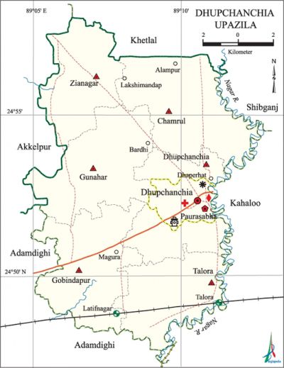
Dhupchanchia Upazila (bogra district) area 162.44 sq km, located in between 24°48' and 24°58' north latitudes and in between 89°05' and 89°13' east longitudes. It is bounded by khetlal upazila on the north, adamdighi and kahaloo upazilas on the south, shibganj and Kahaloo upazilas on the east, Adamdighi and akkelpur upazilas on the west.
Population Total 176678; male 87073, female 89605; Muslim 162682, Hindu 13933, Christian 6 and others 57.
Water bodies Main rivers: ichamati, nagar.
Administration Dhupchanchia Thana was formed in 1880 and it was turned into an' upazila in 1983. Dhupchanchia Municipality was established in 2000.
| Upazila | ||||||||
| Municipality | Union | Mouza | Village | Population | Density (per sq km) | Literacy rate (%) | ||
| Urban | Rural | Urban | Rural | |||||
| 1 | 6 | 109 | 212 | 22406 | 154272 | 1088 | 61.6 | 50.3 |
| Municipality | ||||||||
|
Area (sq km) |
Ward |
Mahalla |
Population |
Density |
Literacy rate (%) | |||
| 10.35 | 9 | 37 | 22406 | 2165 | 61.6 | |||
| Union | ||||
| Name of union and GO code | Area (acre) | Population | Literacy rate (%) | |
| Male | Female | |||
| Gunahar 54 | 7209 | 13163 | 13938 | 50.0 |
| Gobindapur 40 | 7205 | 15080 | 15901 | 53.6 |
| Chamrul 13 | 7948 | 13797 | 14220 | 46.6 |
| Zianagar 81 | 5463 | 10008 | 10510 | 47.1 |
| Talora 67 | 5665 | 13582 | 14142 | 55.3 |
| Dhupchanchia 27 | 4094 | 9985 | 9946 | 46.7 |
Source Bangladesh Population Census 2011, Bangladesh Bureau of Statistics.

Archaeological heritage and relics Goyabandh Mazar, Mazar of Pir Ziauddin, Gobindapur Temple (Gobindapur union).
War of Liberation The Pak army entered this upazila for the first time on 10 April 1971. On 11 April they killed one person in front of the Dhupchanchia Union Parishad office; they also killed 11 persons at the house of Zamindar Khitish Chandra Chowdhury. In the first part of August the freedom fighters of this upazila destroyed the Bara Chapra Railway bridge and towards the end of the month they destroyed the Kahaloo bridge on the Akkelpur Roykali road of Zianagar. Besides, the freedom fighters killed two EPR personnel in front of the Union Parishad office. There is a mass grave at a Padmapukur by the side of the Talora Dhupchanchia road.
For details: see দুপচাঁচিয়া উপজেলা, বাংলাদেশ মুক্তিযুদ্ধ জ্ঞানকোষ (Encyclopedia of Bangladesh War of Liberation), বাংলাদেশ এশিয়াটিক সোসাইটি, ঢাকা ২০২০, খণ্ড ৪।
Religious institutions Mosque 346, temple 52, tomb 4.
Literacy rate and educational institutions Average literacy 51.7%; male 55.6% female 47.9%. Educational institutions: College 5, technical college 3, secondary school 20, primary school 11, madrasa 22. Noted educational institutions: Talora Altaf Ali High School (1918), Dhupchanchia Pilot High School (1923), Dhupchanchia Pilot Girls' High School (1944).
Newspapers and Periodicals Kalomer Chhoa.
Cultural organisations Club 59, public library 1, shilpakala academy 1, press club 1, cinema hall 4, auditorium 1, community centre 4.
Main sources of income Agriculture 66.44%, non-agricultural labourer 2.77%, industry 0.74%,' commerce 13.84%, transport and communication 3.97%, service 4.43%, construction 0.65%, religious service 0.12%, rent and remittance 0.65% and others 6.39%.
Main crops Paddy, jute, potato, mustard and wheat.
Extinct and nearly extinct crops Sesame, linseed seed, arahar.
Main fruits Mango, jackfruit, banana, palm.
Fisheries, dairies and poultries This upazila has a number of fisheries, dairies and poultries.
Communication facilities Pucca road 99 km, semi pacca road 11 km, mud road 206 km; railways 10 km.
Extinct or nearly extinct traditional transport Palanquin, bullock cart, horse carriage.
Noted manufactories Rice mill, oil mill, saw mill, toy industry, aluminum factory, mixed fertilizer factory, biscuit factory, ice cream factory.
Cottage industries Goldsmith, blacksmith, weaving, potteries, wood work, embroidery.
Hats, bazars and fairs Hats and bazars are 15, fairs 13, most noted of which are Dhaperhat, Zianagar Hat, Talora Hat, Saharpukur Hat and Dhap Mela, Goyamenda Mela, Navanna Mela and Bijoy Mela.
Main exports Paddy, rice, biscuit, fish, milk.
Access to electricity All the wards and unions of the upazila are under rural electrification net-work; however, 65.4% dwelling households have access to electricity.
Sources of drinking water Tube-well 94.2%, tap 2.1% and others 3.7%. The presence of arsenic has been detected in shallow tube well of this upazila.
Sanitation 62.9% of dwelling households of the upazila use sanitary latrines and 25.5% of dwelling households use non-sanitary latrines; 11.6% of households do not have latrine facilities.
Health centres Upazila health centre 1, rural health centre 1, satellite clinic 3, family welfare centre 5, child and maternity welfare centre 1, clinic 4, diagnostic centre 1.
Natural disasters The cyclone of April of 2004 caused heavy damages to nearly 200 houses and crops of villages Dhap Sultanganj, Kholash, Mostafapur and Nemaikola of the upazila.
NGO activities asa, brac, thengamara mahila sabuj sangha, SDO, Seba. [Md Khairul Alam Pulak]
References Bangladesh Population Census 2001 and 2011, Bangladesh Bureau of Statistics; Cultural survey report of Dhupchanchia Upazila 2007.
