Golapganj Upazila
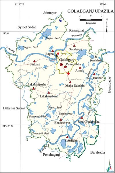
Golapganj Upazila (sylhet district) area 278.33 sq km, located in between 24°41' and 24°55' north latitudes and in between 91°55' and 92°06' east longitudes. It is bounded by sylhet sadar, jaintiapur and kanaighat upazilas on the north, fenchuganj and barlekha upazilas on the south, beanibazar and Barlekha upazilas on the east, Sylhet Sadar and dakshin surma upazilas on the west.
Population Total 316149; male 154249, female 161900; Muslim 302479, Hindu 13603, Buddhist 11, Christian 29 and others 40. Indigenous communities such as manipuri and tripura belong to this upazila.
Water bodies Main rivers: surma, kushiyara, Sonai; Singari Beel, Bagha Beel, Fatamati Beel, Parea Beel and Sonadubi Beel are notable.
Administration Golapganj Thana was formed in 1922 and it was turned into an upazila in 1983.
| Upazila | ||||||||
| Municipality | Union | Mouza | Village | Population | Density (per sq km) | Literacy rate (%) | ||
| Urban | Rural | Urban | Rural | |||||
| 1 | 11 | 98 | 244 | 37457 | 278692 | 1136 | 54.68 (2001) | 56.3 |
| Municipality | ||||||||
| Area (sq km) |
Ward | Mahalla | Population | Density (per sq km) |
Literacy rate (%) | |||
| - | 9 | 23 | 32444 | - | 62.2 | |||
| Upazila Town | ||||||||
|
Area |
Mouza |
Population |
Density |
Literacy rate | ||||
| 11.14 (2001) | 1 | 5013 | 1621 (2001) | 60.5 | ||||
| Union | ||||
| Name of union and GO code | Area (acre) | Population | Literacy rate (%) | |
| Male | Female | |||
| Amura 06 | 5010 | 8839 | 9151 | 55.3 |
| Uttar Bade Pasha 77 | 5428 | 10586 | 11953 | 53.6 |
| Golapganj 51 | 3147 | 7972 | 8392 | 60.3 |
| Dhaka Dakshin 25 | 9079 | 16693 | 17677 | 62.6 |
| Fulbari 43 | 5246 | 13993 | 13883 | 56.9 |
| Bagha 08 | 9770 | 16624 | 17327 | 50.7 |
| Budbari Bazar 20 | 2807 | 8483 | 8784 | 54.0 |
| Bhadeshwar 17 | 8131 | 17472 | 18800 | 61.2 |
| Lakshanaband 69 | 6841 | 15216 | 16160 | 56.3 |
| Lakshmi Pasha 60 | 4327 | 11625 | 12276 | 56.9 |
| Shorifgonj 36 | 4913 | 10341 | 11458 | 48.5 |
Source Bangladesh Population Census 2001 and 2011, Bangladesh Bureau of Statistics.

Archaeological heritage and relics Mazar of Hazrat Bahauddin (R), house and temple of sri chaitanya Dev, Kailash Tila and Dewan Bridge.
Historical events Ronikeli and Bhadeshwar revolts were held in the upazila as a part of the historic Nankar Movement.
War of Liberation A resistance encounter was held at Baitikar on 13 April 1971. Freedom fighters had later a number of encounters with the Pak army at Mokamtila, Mollarkona, Hakaluki, Lama, Meherpur and other places of the upazila. There is a mass grave at Sundisail;, a memorial monument has been built in the upazila.
For details: see গোলাপগঞ্জ উপজেলা, বাংলাদেশ মুক্তিযুদ্ধ জ্ঞানকোষ (Encyclopedia of Bangladesh War of Liberation), বাংলাদেশ এশিয়াটিক সোসাইটি, ঢাকা ২০২০, খণ্ড ৩।
Religious institutions Mosque 445, temple 3, church 1, tomb 9. Noted religious institutions: Bhadeshwar Mokambazar Jami Mosque.
Literacy rate and educational institutions Average literacy 57.0%; male 58.2%, female 55.9%. Educational institutions: college 3, technical college 1, secondary school 33, primary school 160, community school 15, kindergarten 60, madrasa 19. Noted educational institutions: Dhaka Dakshin Degree College, Bhadeshwar Mahila Degree College, Dhaka Dakshin Multilateral High School and College (1898), Bhadeshwar Nasiruddin High School (1919), MC Academy (1934), Fulbaria Madrasa (1882).
Newspapers and periodicals Weekly; Golap, Sonar Sylhet.
Cultural organisations Library 5, music academy 5, community centre 12, playground 10.
Tourist spots Bangladesh Scouts (Sylhet region), Petrobangla, Kailash Tila and the birth place of Sri Chaitanya Dev.'
Main sources of income Agriculture 34.05%, non-agricultural laborer 6.03%, industry 0.94%, commerce 14.64%, transport and communication 4.01%, service 6.16%, construction 2.88%, religious service 0.58%, rent and remittance 18.34% and others 12.37%.
Ownership of agricultural land Landowner 42.76%, landless 57.24%; agricultural landowner: urban 27.98% and rural 43.91%.
Main crops Paddy, chilli, pumpkin, arum,' barbati.
Extinct or nearly extinct crops Mustard, sesame, linseed.
Main fruits Jackfruit, mango, litchi, banana, latkon, guava, lemon, shaddock, betel nut, coconut.
Fisheries, dairies and poultries Dairy 40, poultry 70.
Communication facilities Pucca road 258 km, semi-pucca road 54 km, mud road 382 km; waterway 18 km. Culvert 300, bridge 84.
Extinct or nearly extinct traditional transport Palanquin, bullock cart.
Noted manufactories LP gas plant.
Cottage industries Ice cream factory, bakery.
Hats, bazars and fairs Hats and bazars are 30, fair 1, Golapganj, Dhaka Dakshin, Bhadeshwar and Mokam bazars; Chaitra Samkranti Mela is notable.
Main exports Natural gas, barbati, pumpkin, chili.
Access to electricity All the wards and unions of the upazila are under rural electrification net-work. However 71.7% of the dwelling households have access to electricity.
Natural resources Gas field 4.
Sources of drinking water Tube-well 87.4%, tap 6.3% and others 6.2%. The presence of intolerable level of arsenic has been detected in 10.03% of shallow tube-well water of the upazila. The presence of arsenic at an intolerable level has been detected in the water of the 10.03% shallow tube-wells of the upazila.
Sanitation 67.3% of dwelling households of the upazila use sanitary latrines and 30.7% of dwelling households use non-sanitary latrines; 2.1% of households do not have latrine facilities.
Health centres Upazila health centre 1, union health centre 1, health and family planning centre 5, community clinic 11, maternity and child welfare centre 1, diagnostic centre 3, veterinary hospital 1.
NGO activities Operationally important NGOs are brac, Simantic. [Azizul Parvez]
References Bangladesh Population Census 2001 and 2011, Bangladesh Bureau of Statistics; Field report of Golapganj Upazila 2010.
