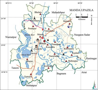
Manda Upazila
Manda Upazila (naogaon district) area 375.93 sq km, located in between 24°37' and 24°53' north latitudes and in between 88°35' and 88°51' east longitudes. It is bounded by mahadebpur upazila on the north, baghmara and mohanpur upazilas on the south, naogaon sadar, raninagar and atrai upazilas on the east, niamatpur and tanore upazilas on the west.
Population Total 363858; male 180023, female 183835; Muslim 329592, Hindu 31791, Buddhist 1, Christian 178 and others 2296.
Water bodies Main rivers: atrai, Shiva; Manda and Uthrail beels are notable.
Administration Manda Thana was formed in 1943 and it was turned into an upazila in 1987.
| Upazila | ||||||||
| Municipality | Union | Mouza | Village | Population | Density (per sq km) | Literacy rate (%) | ||
| Urban | Rural | Urban | Rural | |||||
| - | 14 | 299 | 293 | 12471 | 351387 | 968 | 67.5 | 45.5 |
| Upazila Town | ||||||||
|
Area (sq km) |
Mouza |
Population |
Density (per sq km) |
Literacy rate (%) | ||||
| 7.43 | 5 | 12471 | 1678 | 67.5 | ||||
| Union | ||||
| Name of union and GO code | Area (acre) | Population | Literacy rate (%) | |
| Male | Female | |||
| Kashab 47 | 3944 | 9691 | 10456 | 48.4 |
| Kalikapur 33 | 7049 | 11777 | 11787 | 44.0 |
| Kansopara 40 | 5433 | 12020 | 12282 | 43.6 |
| Kusumba 54 | 7115 | 18438 | 18752 | 62.1 |
| Ganeshpur 27 | 6481 | 13385 | 13800 | 41.5 |
| Tentulia 94 | 9573 | 12722 | 13020 | 46.9 |
| Nurullabad 74 | 7138 | 13743 | 13793 | 42.7 |
| Paranpur 81 | 6663 | 12906 | 13237 | 40.6 |
| Prasadpur 88 | 5608 | 11656 | 11824 | 46.7 |
| Bishnupur 20 | 7035 | 9826 | 9909 | 48.5 |
| Bharso 13 | 12865 | 16996 | 17324 | 42.9 |
| Bhalain 12 | 7584 | 11389 | 11612 | 42.8 |
| Manda 67 | 5309 | 14501 | 14935 | 49.4 |
| Mainani 61 | 6338 | 10973 | 11104 | 41.5 |
Source Bangladesh Population Census 2011, Bangladesh Bureau of Statistics.

Archaeological heritage and relics Six-domed Kushumba Shahi Mosque (1558), Thakur Manda Raghunath Temple, Neel Kuthi at Satihat.
War of Liberation In August 1971 the Pak army killed 128 persons at village Pakuria of Bharsho union of the upazila and buried them in a mass grave. The Pak army also conducted mass killing and heavy plundering and set many houses of the upazila on fire. Freedom fighters carried out operation against the Pak army at Mainam High School and Kalikapur village. There is a mass grave at Manoharpur and a mass killing site at Pakuria.
For details: see মান্দা উপজেলা, বাংলাদেশ মুক্তিযুদ্ধ জ্ঞানকোষ (Encyclopedia of Bangladesh War of Liberation), বাংলাদেশ এশিয়াটিক সোসাইটি, ঢাকা ২০২০, খণ্ড ৮।
Religious institutions Mosque 922, temple 21, church 2, sacred place 1.
Literacy rate and educational institutions Average literacy 46.3%; male 51.5%, female 41.2%. Educational institutions: college 13, secondary school 75, primary school 207, kindergarten 2, madrasa 13. Noted educational institutions: Manda Momen Sahana Degree College (1970), Mainani Multilateral High School (1895), Manda Pilot High School (1914), Pajor Bhanga Primary School (1901), Majidpur Fazil Madrasa (1970).
Cultural organisations Library 1, club 41, cinema hall 4, playground 146.
Main sources of income Agriculture 78.75%, non-agricultural labourer 2.28%, industry 0.68%, commerce 8.99%, transport and communication 1.86%, service 2.69%, construction 0.49%, religious service 0.09%, rent and remittance 0.08% and others 4.09%.
Main crops Paddy, wheat, mustard, potato, sugarcane, sesame, kalai, vegetables.
Extinct or nearly extinct crops Kaun, barley, linseed, arahar,
Main fruits Mango, litchi, banana, jackfruit, guava, papaya.
Fisheries, dairies and poultries Fishery 6, dairy 79, poultry 95.
Communication facilities Pucca road 311 km, semi-pucca road 35 km, mud road 472 km. Extinct or nearly extinct traditional transport Palanquin, horse carriage, bullock cart.
Noted manufactories Rice mill, welding factory.
Cottage industries Goldsmith, blacksmith, potteries, bamboo work.
Hats, bazars and fairs Hats and bazars are 30, fairs 5, most noted of which are Chaubadia Hat, Shabai Hat, Deluabari Hat, Sati Hat and Prasadpur Hat.
Main exports Paddy, wheat, sugarcane molasses, banana, papaya.
Access to electricity All the unions of the upazila are under rural electrification net-work. However 32.1% of the dwelling households have access to electricity.
Sources of drinking water Tube-well 93.9%, tap 1.3% and others 4.8%. The presence of arsenic has been detected in shallow tube-well water of the upazila.
Sanitation 32.4% of dwelling households of the upazila use sanitary latrines and 46.5% of dwelling households use non-sanitary latrines; 21.1% of households do not have latrine facilities.
Natural disasters Many people were victims of the famine of 1770 (popularly known as manvantar of 1176, BS) and the epidemic following the floods of 1962 and 1995.
Health centres Upazila health complex 1, health and family planning centre 9, family planning centre 12, community clinic 49.
NGO activities Operationally important NGOs are brac, asa, CARE, thengamara mahila sabuj sangha. [Md.Abu Rashed]
References Bangladesh Population Census 2001 and 2011, Bangladesh Bureau of Statistics; Cultural survey report of Manda Upazila 2007.
