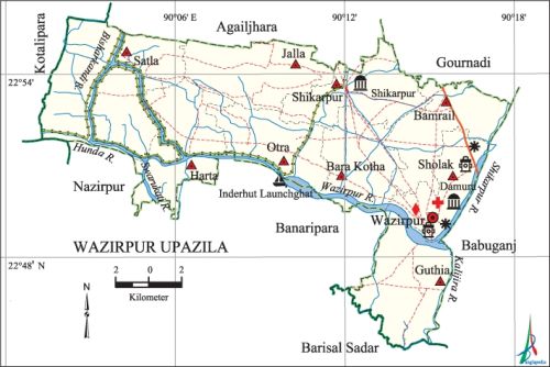
Wazirpur Upazila
Wazirpur Upazila (barisal district) area 248.36 sq km, located in between 22°43' and 22°56' north latitudes and in between 90°01' and 90°18' east longitudes. It is bounded by agailjhara and gaurnadi upazilas on the north, banaripara and barisal sadar upazilas on the south, babuganj upazila on the east, kotalipara and nazirpur upazilas on the west.
Population Total 234959; male 113529, female 121430; Muslim 171282, Hindu 61446, Buddhist 32, Christian 2192 and others 7.
Water bodies Main rivers: Wazirpur, Kalijira, Bisharkandi, Hunda, Swarupkati, Shikarpur.
Administration Wazirpur Thana was turned into an upazila in 1983.
| Upazila | ||||||||
| Municipality | Union | Mouza | Village | Population | Density (per sq km) | Literacy rate (%) | ||
| Urban | Rural | Urban | Rural | |||||
| - | 9 | 118 | 125 | 11716 | 223243 | 946 | 78.4 | 61.6 |
| Upazila Town | ||||||||
|
Area (sq km) |
Mouza |
Population |
Density |
Literacy rate (%) | ||||
| 6.48 | 4 | 11716 | 1808 | 78.4 | ||||
| Union | ||||
| Name of union and GO code | Area (acre) | Population | Literacy rate (%) | |
| Male | Female | |||
| Otra 63 | 5626 | 11853 | 13218 | 61.4 |
| Guthia 31 | 7256 | 11747 | 13124 | 70.6 |
| Jalla 52 | 6715 | 11871 | 12571 | 58.5 |
| Bamrail 10 | 6193 | 13078 | 14530 | 71.0 |
| Bara Kotha 21 | 5553 | 12237 | 13899 | 54.5 |
| Shikarpur 84 | 4876 | 14218 | 14754 | 73.6 |
| Sholak 94 | 6001 | 13462 | 14327 | 62.3 |
| Satla 73 | 12297 | 13491 | 13582 | 53.9 |
| Harta 42 | 6856 | 11572 | 11425 | 53.7 |
Source Bangladesh Population Census 2011, Bangladesh Bureau of Statistics.

War of Liberation In 1971 the Pak army burnt more than three hundred houses and killed many people by gunshot at village Dhamura. A direct encounter was held between the freedom fighters and the Pak army at village Bagrarpar in which many Pakistani soldiers were killed.
For details: see উজিরপুর উপজেলা, বাংলাদেশ মুক্তিযুদ্ধ জ্ঞানকোষ (Encyclopedia of Bangladesh War of Liberation), বাংলাদেশ এশিয়াটিক সোসাইটি, ঢাকা ২০২০, খণ্ড ১।
Noted religious institutions Shikarpur Jami Mosque, tomb of Dhamura Mia, Harta Gobindha Temple, Dhamshar Church, Tarabari Temple.
Literacy rate and educational institutions Average literacy 62.5%; male 64.0%, female 61.1%. Noted educational institutions: Habibpur Secondary School (1856), Revrouddradi Government Primary School (1887), Sher-e- Bangla College (1970), Dhamura College (1970), Wazirpur College (1985), ZA Khan High School, Babar Ghana High School, Baherghat Secondary School, Abdul Mazid Secondary School, Guthia Maheshchandra Secondary School, Ramerkati Secondary School, Gazirpara Secondary School, Atipara Government Primary School (1914).
Cultural organisations Library 13, rural club 15, cinema hall 2, playground 10, theatre group 5.
Main sources of income Agriculture 57.52%, non-agricultural labourer 2.05%, commerce 16%, transport and communication 2.04%, service 12.15%, construction 2.25% and others 7.99%.
Ownership of agricultural land Landowner 77.01%, landless 22.99%; agricultural landowner: urban 58.92% and rural 77.83%.'
Main crops Paddy, potato, betel leaf, sugarcane, vegetables.
Extinct or nearly extinct crops Sesame, linseed, mustard, kalai, sweet potato, jute.
Main fruits Mango, blackberry, jackfruit, papaya, litchi, guava, banana, betel nut.
Fisheries, dairies and poultries Fishery 730, dairy 56, poultry 87, hatchery 1.
Communication facilities Pucca road 127 km, semi-pucca road 74 km, mud road 637 km; waterway 240 km.
Extinct or nearly extinct traditional transport Palanquin, dulki.
Noted manufactories Rice mill 34, flour mill 20, ice factory 4, saw mill 10, oil mill 3, bidi factory 1, lathe machine 4, welding factory 8.
Cottage industries Blacksmith 85, potteries 117, weaving 5, bamboo work 125.
Hats, bazars and fairs Hats and bazars are 22, fairs 8, most noted of which are Dhamura Hat, Harta Hat and Shikarpur Mela.
Main exports Paddy, betel leaf, betel nut.
Access to electricity All the unions of the upazila are under rural electrification net-work. However 50.2% of the dwelling households have access to electricity.
Sources of drinking water Tube-well 96.7%, tap 0.1% and others 3.2%. The presence of arsenic has been detected in shallow tube-well water of the upazila.
Sanitation 90.6% of dwelling households of the upazila use sanitary latrines and 8.1% of dwelling households use non-sanitary latrines; 1.3% of households do not have latrine facilities.
Health centres Upazila health complex 1, family planning centre 9, satellite clinic 4.
Natural disasters The cyclone and earthquake of 1762 changed the formation of land of the region and turned the high land into beel. The flood of 1787 caused heavy damages to crops of the upazila. Many people were victims of the cyclones of 1770, 1822, 1825, 1832, 1855, 1909 and 1960. These cyclones also caused heavy damages to settlements and other properties of the upazila.
NGO activities Operationally important NGOs are brac, proshika, asa, caritas. [Md. Mizanur Rahman]
References Bangladesh Population Census 2001 and 2011, Bangladesh Bureau of Statistics; Cultural survey report of Wazirpur Upazila 2007.
