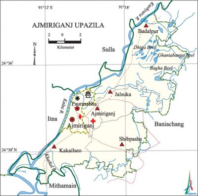
Ajmiriganj Upazila
Ajmiriganj Upazila (habiganj district) area 223.98 sq km, located in between 24°27' and 24°40' north latitudes and in between 91°09' and 91°25' east longitudes. It is bounded by sulla and baniachang upazilas on the north, Baniachang and mithamain upazilas on the south, Baniachang upazila on the east and ITNA upazila on the west.
Population Total 99294; male 51383, female 47911; Muslim 70753, Hindu 28442, Buddhist 9, Christian 40 and others 50.
Water bodies Main rivers: Kalni, kushiyara, Khaikal; Ghaniabanga, Bagha and Dhiga beels are notable.
Administration Ajmiriganj Thana was formed in 1922 and it was turned into an upazila in 1983.
| Upazila | ||||||||
| Municipality | Union | Mouza | Village | Population | Density (per sq km) | Literacy rate (%) | ||
| Urban | Rural | Urban | Rural | |||||
|
1 |
5 |
68 |
89 |
14381 |
84913 |
443 |
48.89 |
32.81 |
| Upazila Town | ||||
|
Area |
Mouza |
Population |
Density |
Literacy rate |
|
5.74 |
2 |
14381 |
2505 |
51.95 |
| Union | ||||
| Name of union and GO code | Area (acre) | Population | Literacy rate (%) | |
| Male | Female | |||
|
Ajmiriganj 13 |
4861 |
11495 |
10089 |
44.57 |
|
Kakailseo 67 |
7611 |
12661 |
11781 |
31.24 |
|
Jalsuka 54 |
6161 |
7416 |
6914 |
32.69 |
|
Badalpur 27 |
17461 |
10059 |
9334 |
41.62 |
|
Shibpasha 81 |
9414 |
9752 |
9793 |
24.50 |
Source Bangladesh Population Census 2001,Bangladesh Bureau of Statistics.
History of the War of Liberation During the war of liberation in 1971 a prolonged eighteen hours encounter between the freedom fighters and the Pak army was held on 16 November in which freedom fighter Jagatyoti was killed. Besides, the Pak army brutally killed 11 innocent villagers.
Religious institutions Mosque 60, temple 35, tomb 5.

Literacy rate and educational institutions Average literacy 35.28%; male 40.13%, female 30.12%. Educational institutions: college 2, secondary school 6, primary school 88, kindergarten 1, madrasa 6. Noted educational institutions: Jalsuka Krishna Govinda Public High School (1876), Paharpur Basanta Kumar High School.
Cultural organizations Library 2, literary society 1, auditorium 1, cinema hall 1, playground 2.
Main sources of income Agriculture 64.83%, non-agricultural labourer 5.02%, commerce 16.15%, transport and communication 0.36%, service 2.77%, construction 0.83%, religious service 0.43%, rent and remittance 0.88% and others 8.73%.
Ownership of agricultural land Landowner 51.62%, landless 48.38%; agricultural landowner: urban 28.72% and rural 55.39%.
Main crops Paddy, jute, potato, groundnut.
Extinct or nearly extinct crops Sesame, linseed.
Main fruits Mango, Jackfruit, coconut.
Fisheries, dairies and poultries Fishery 43, dairy 44, poultry 39.
Communications facilities' Roads: pucca road 8.5 km, semi-pucca road 15 km, mud road 110 km; waterways 50 nautical miles.
Extinct or nearly extinct traditional transport' palanquin.
Noted manufactories Cold storage for preservation of fish, fish processing industry.
Cottage industries glodsmith, blacksmith, potteries, woodworks.
Hats, bazars and fairs Hats and bazars are 5, fairs 4; most noted of which are Ajmiriganj, Kakaieo and Shibpasha bazars.
Main exports Shrimp, dried fish, paddy.
Access to electricity All the wards and unions of the upazila are under rural electrification network. However 10.13% of the dwelling households have access to electricity.
Sources of drinking water Tube-well 95.21%, pond 2.67%, tap 1.63% and others 0.49%.
Sanitation 11.75% (rural 10.08% and urban 21.88%) of dwelling households of the upazila use sanitary latrines and 80.47% (rural 83.11% and urban 64.44%) of dwelling houses use non-sanitary latrines; 7.78% of households do not have latrine facilities.
Health centres Upazilla health complex 1, union health and family planning centre 1, family planning centre 2, clinic 4, mother and child welfare centre 1, charitable hospital 1, satellite clinic 1, diagnostic centre 1, private clinic 1.
NGO activities Operationally important NGOs are brac, asa, CARE, Vision. [Jiban Kumar Chanda]
References Bangladesh Population Census 2001, Bangladesh Bureau of Statistics; Field report of Ajmiriganj Upazila 2010.
