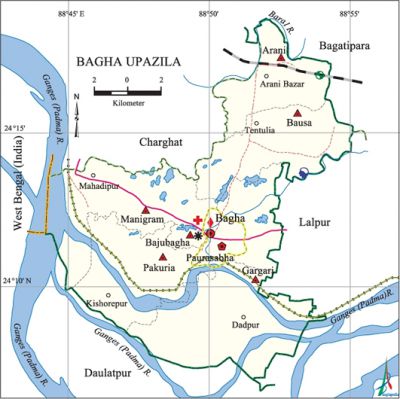
Bagha Upazila
Bagha Upazila (rajshahi district) area 185.16 sq km, located in between 24°07' and 24°19' north latitudes and in between 88°44' and 88°55' east longitudes. It is bounded by charghat and bagatipara upazilas on the north, daulatpur (kushtia) upazila on the south, lalpur and Bagatipara upazilas on the east, west bengal (India) and Padma river on the west.
Population Total 184183; male 92010, female 92173; Muslim 174423, Hindu 9590, Christian 49 and others 121.
Water bodies 'Main rivers: padma, baral.
Administration Bagha Thana was turned into an upazila on 26 March 1983.
| Upazila | ||||||||
| Municipality | Union | Mouza | Village | Population | Density (per sq km) | Literacy rate (%) | ||
| Urban | Rural | Urban | Rural | |||||
| 2 | 6 | 82 | 78 | 44173 | 140010 | 995 | 54.6 | 48.1 |
| Arani Municipality | ||||||||
| Area (sq km) |
Ward | Mahalla | Population | Density (per sq km) |
Literacy rate (%) | |||
| - | 9 | 22 | 16550 | - | 52.1 | |||
| Bagha Municipality | ||||||||
| Area (sq km) |
Ward | Mahalla | Population | Density (per sq km) |
Literacy rate (%) | |||
| 10.99 (2001) | 9 | 28 | 27623 | 2005 (2001) | 55.2 | |||
| Union | ||||
| Name of union and GO code | Area (acre) | Population | Literacy rate (%) | |
| Male | Female | |||
| Arani 13 | 2761 | 5178 | 5204 | 50.5 |
| Gargari 55 | 10849 | 13973 | 13830 | 43.9 |
| Pakuria 79 | 7358 | 13750 | 14097 | 51.2 |
| Bausa 23 | 7558 | 14186 | 14211 | 50.8 |
| Bajubagha 15 | 3521 | 6828 | 7055 | 44.9 |
| Manigram 63 | 7971 | 15919 | 15779 | 47.0 |
Source Bangladesh Population Census 2001 and 2011, Bangladesh Bureau of Statistics.

Archaeological heritage and relics Ten-domed Bagha Shahi Mosque and Dighi (1523), Neelkuthi at Mirganj (presently used as silk factory), Mazar of Dilal Bukheri (R) at Alaipur.
Historical events Alaipur village of Bhaga was the head quarter of Laskar Khan Jaigirdar during the sixteenth century. Hazrat Shah Dolah settled at Bagha and started preaching Islam. He also established a madrasa here.
War of Liberation During the war of liberation in 1971 the Pak army established temporary camps at different places of Bagha including at Arani, Bagha, Narayanpur, Pakuria, Chawkrajapur and Alaipur. Freedom fighters had a number of encounters with the Pak army at these places. In the face of heroic resistance of the freedom fighters of the upazila the Pak army was forced to flee to places like Pabna, Arani, Natore and Nandangachhi. Also, the people of those villagers killed many Pakistani soldiers. About 400 freedom fighters of Bagha Upazila participated in the War of Liberation and of them, 7 had lost their lives.
For details: see বাঘা উপজেলা, বাংলাদেশ মুক্তিযুদ্ধ জ্ঞানকোষ (Encyclopedia of Bangladesh War of Liberation), বাংলাদেশ এশিয়াটিক সোসাইটি, ঢাকা ২০২০, খণ্ড ৬।
Religious institutions Mosque 343, temple 36, tomb 5, sacred place 2. Noted religious institutions: tomb of Hazrat Shah Dolah, Mandir of Khapa Baba.
Literacy rate and educational institutions Average literacy 49.6%; male 51.9%, female 47.4%. Educational institutions: college 19, secondary school 49, primary school 42, madrasa 25. Noted educational institutions: Shah Dolah Degree College, Abdul Ghani College, Mirganj College, Alhaz Ershad Ali Mahila College, Arani College, Arani Manmohini High School (1865), Bagha High School.
Newspapers and periodicals Monthly: Mukta Kantha; Periodicals: Mitrika, Sharani, Baghabarta.
Cultural organisations Library 6, club 25, press club 1, women association 12, cinema hall 1, playground 22.
Main sources of income Agriculture 63.57%, non-agricultural labourer 5.47%, industry 1.14%, commerce 17%, transport and communication 2.05%, service 3.36%, construction 0.53%, religious service 0.13%, rent and remittance 0.11% and others 6.64%.
Ownership of agricultural land Landowner 57.52%, landless 42.48%; agricultural landowner: urban 46.97% and rural 59.13%.
Main crops Paddy, wheat, jute, sugarcane, black gram, mulberry, ground nut, turmeric, vegetables.'
Extinct or nearly extinct crops Sweet potato, sesame, linseed, aush paddy, arahar.
Main fruits Mango, jackfruit, litchi, guava, date.
Fisheries, dairies and poultries Fishery 110, dairy 18, poultry 106.
Communication facilities Pucca road 168 km, semi-pucca road 35 km, mud road 262 km; railway 5 km.
Extinct or nearly extinct traditional transport Palanquin, bullock cart and horse carriage.
Noted Manufactories Rice mill 15, ice factory 2, saw mill 5, welding 20.
Cottage industries Goldsmith 35, potteries 105, cobbler 67, cocoon industry 1, wood work 325, bamboo work 250.
Hats, bazars and fairs Hats and bazars are 26, fairs 2, most noted of which are Bagha, Mirganj, Chandipur, Narayanpur, Arani, Manigram, Rustampur hats and Bagha Eid Mela.
Main exports Paddy, wheat, jute, mango, jackfruit, turmeric, cocoon, sugarcane, date molasses.
Access to electricity All the wards and unions of the upazila are under rural electrification net-work. However 52.5% of the dwelling households have access to electricity.
Sources of drinking water Tube-well 97.7%, tap 0.7% and others 1.6%. The presence of arsenic in shallow tube-well water of the upazila has been detected.
Sanitation 35.1% of dwelling households of the upazila use sanitary latrines and 55.5% of dwelling houses use non-sanitary latrines; 9.4% of households do not have latrine facilities.
Health centres Upazila health centre 1, family planning centre 6, clinic 3.
Natural Disaster' In 2009 4 km area of land and 677.26 hectors of agricultural land were submerged in the Padma river bed due to erosion.
NGO activities Operationally important NGOs are brac, asa, caritas, thengamara mahila sabuj sangha. [AKM Kaisaruzzaman]
References Bangladesh Population Census 2001 and 2011, Bangladesh Bureau of Statistics; Cultural survey report of Bagha Upazila 2007.
